Kulgam
Kulgam (Urdu:کُلگام) is a town, administrative division, and capital of the Kulgam district in the Indian union territory of Jammu and Kashmir. It is located at a distance of 67 km (42 mi) from the summer state capital of Jammu and Kashmir, Srinagar. The city is divided into 16 electoral wards that has population of 23,584, of which 12,605 are males while 10,979 are females.[5]
Kulgam | |
|---|---|
Town | |
 Kulgam Location in Jammu and Kashmir, India  Kulgam Kulgam (India) | |
| Coordinates: 33°38′24″N 75°01′12″E | |
| Country | |
| Union territory | Jammu and Kashmir |
| District | Kulgam |
| Government | |
| • Type | Democracy |
| • Body | Govt. of Jammu & Kashmir |
| Area | |
| • Total | 1,067 km2 (412 sq mi) |
| Elevation | 1,739 m (5,705 ft) |
| Population (2011 [1]) | |
| • Total | 23,584 |
| • Density | 22/km2 (57/sq mi) |
| Languages | |
| • Official | Urdu, Kashmiri |
| Time zone | UTC+5:30 (IST) |
| PIN CODE | 192231,[2] |
| Telephone code | 01931 [3] |
| Vehicle registration | JK18 JK18A, JK18B, JK18C [4] |
| Literacy rate | 60% |
| Sex Ratio | 951 ♀/ 1000 ♂ |
| Website | https://kulgam.nic.in/ |
Geography
Kulgam is located at 33°38'24" N 75°01'12" E. It has an average elevation of 1739 metres (5705 feet). Now it has become a separate district of Jammu and Kashmir. Kulgam is known for a religious saint (Sayed Simnan Sahib), who gave it the name "Kulgam" ("Kul" means "stream" in kashmiri; "gam" in kashmiri means "village") as the area has a lot of streams. Syed Simnan came from a place called Simnan in Iran. Travelling in the Kashmir valley, he came to Kulgam and liked the spot on a cliff overlooking the river Veshaw. He made Kulgam his permanent abode and was buried at the very spot which he had found fascinating. His 'aastan' is a draw from the population in and around Kulgam.[6] The family of Syed Simnan is buried in a nearby village called Amun. Both the shrines have a masonry plinth and a wooden superstructure of deodars. He was known for his mystical powers and had devotees amongst Muslims as well as Hindus.[7]
Sheikh Noor-ud-Din Noorani also known as Nund Rishi, was a Kashmiri saint who belonged to the Rishi order and is also called Alamdar-e-Kashmir. Sheikh-ul-Alam as the patron saint of Kashmiris, revered by both Muslims and Hindus, was also born in a village called Kaimuh of the Kulgam distinct in 779 A.H. (AD 1377). The family of Shaikh Nur-ud-din is buried in Quimoh. The Kulgam area is the birthplace of the ancestors of Allama Iqbal (Supur village). Pandit Jawaharlal Nehru's ancestors also are from Nadi Marag, a village in Kulgam. Aharbal is a tourist spot in the district of Kulgam. It is a high waterfall, which is a source of the river Veshaw. Kulgam is known as the rice bowl of the valley and is known for its variety of fruit, especially apples.[8][9]
This town is on the bank of river Veshaw across the spread of which are the foothills of the Pir Panchal mountains. Ahrabal has meadows and a waterfall. It has its origin from a spring called Kausar Nag located in the mountain range of Pir Panjal Range.
The partial excavation of an archaeological site in a nearby village called Kutbal has yielded material culture from the period of Kushan rule in the region.[10][11] Stamped tiles, which were excavated from the site, indicated the taste and living standard of the population.[12][13] These excavations speak of high culture, civic sense, social norms and art of the people living in first century AD.
The Kutbal site and its findings, which belong to the Kushana period, are more significant in view of several religious and artistic practices that had flourished then and had travelled to far off places in the subcontinent. Further excavation has been stopped due to prevailing political unrest in valley.
Topography
The old Kulgam is situated on the banks of "Kaval". The topography of Kulgam is. The lower portion is situated on the banks of Kaval, offshoot of river Veshaw. Almost all offices are functioning in this area. A scenic nullaha Veshaw irrigates the fertile lands of Kulgam area. Kulgam is called the granary of Kashmir Valley, but unfortunately this area is almost converted into agriculture to horticulture. Kulgam is famous being the first seat of missionaries of Islam as before Sayeed Ali Hamdani, he sent Sayeed Mohmmad Hussain SImnani to Kashmir to preach for Islam. Sayeed Simnani chose Kulgam as a permanent seat. It is the place where Salar Sanz father of Sheikh Noor-ud-Din wali embraced Islam and was renamed Salar ud-din, Salar resides at Khee Jogipora Mohmad pora 7 kilometres (4 mi) from Kulgam and was married to Sadder, a daughter of Kota rajas of Daderkot. It was due to the efforts of sayeed simnani this marriage took place. Kulgam is an important place in South Kashmir. Kulgam connects, and its boundaries touch, all the three districts Shopian, Pulwama, and Anantnag of South Kashmir. The topography of Kulgam is scenic, and it is surrounded on all sides by small streams 'orchards; paddy farms and a scenic Kerwaha with a big portion of plan area and fields.
Habitation & Environment
- The main source of livelihood in the district is Agriculture & Horticulture. The low-lying areas of Kulgam are very fertile for rice cultivation (known for best yield) so it is considered as 'Rice Bowl of Kashmir'. On the other hand, the upper areas are known for production of quality apple, Pears. Livestock and sheep rearing is a subsidiary occupation in rural population particularly in the upper areas.[14]
- The District Kulgam is covered by mighty & majestic Pir Panjal mountain range on the north west side acting as a massive topographical protection. The area is significantly covered in forestation.
Sight Seeing
Town Kulgam is situated at a distance of about 68 km from Srinagar and about 17 km from Anantnag. It has road connectivity with its neighboring districts like Shopian, Pulwama, Anantnag and Ramban etc. and Town besides being linked with far flung areas of the District by a dependable road network. Besides places of spiritual interest the district has tourist spots like "Ahrabal water fall" on Veshaw River, Amnoo Eid Gah which is a place of sight-seeing in the extreme south-west of district Kulgam., Kongwattan and Gurwattan ahead of Ahrabal, Charenbal and Nandimarg high land pastures are also places of tourist attraction apart from virgin meadows in the area from Kund to Ladigasan (ahead of Aherbal clefts). The District also has super abundance of natural water resources in the shape of various famous springs such as, Kausar Nag (ahead of Aherbal), Waseknag (Kund), Khee Nag( Khee Jogipora), etc.
Political Status
Kulgam district has 4 assembly constituencies: Noorabad, Kulgam, Homshailibugh, and Devsar. Veteran CPIM Leader Mohmmad Yousuf Tarigami was MLA from the Kulgam constituency,He played important role in the development of the district. Nazir Ahmad Laway who is presently Member of Parliament in Rajya Sabha representing the state of Jammu & Kashmir also belongs to Kulgam.
Road facility
Kulgam has following roads connecting it to various assembly segments and with NH1A (Major District Roads)
- Anantnag-Ashmuji-brazloo-Kulgam Main Road
- Kulgam-Chawalgam-Muhammad Pra - Shopian Road
- Wanpoh-Qaimoh-Kulgam Road
- NH1A Mirbazar to Kulgam via Akhran, Hablishi, Kilam, Pirpora & brazloo
- Qaimoh-Kadder-Hanjan-Shopian Road
- Bijbehara-Arwani-Frisal-Yaripora Bugam-kulgam Road
- Qazigund-Devsar-Pahloo-brazloo-Kulgam Road
- Kulgam-Shopian Road
- Kulgam-Nehama-Aharabal Road
- Kulgam-Damhal—Aharabal Road
- Kulgam-Damhal- Aharabal Road
- Kulgam-Ardigatnoo-Laisoo Road
- Kulgam-Laisoo-Damhal Hanjipora Road
Khudwani-Frisal-Zainpora Road Frisal-Damidallah-Buchroo Road Frisal-Kralchek-Nagharad road Frisal- Nawbal-Shamsipora-Batingoo Road
Health facilities
- District Hospital Kulgam
- Sub district hospitals at Yaripora and Damhall.
- 24x7 Emergency Hospital Qazigund [Medically some areas of Qazigund are under Kulgam]
- PHCs at Frisal, Qaimoh, Bugam, Pahloo, Devsar, Behibagh Mohammad Pora, Katrsoo, Kilam, Akhran, GB Khalil, KB-pora, nehama etc.[15]
Economy
Majority of population of the district directly or indirectly depend upon on agriculture,also services sector is main source of income. land of upper areas of the district is fertile for horticulture lower areas for paddy crop etc. Government had setup Fruit Mandi Kulgam where People sell Apples, cherry etc to local and national buyers.
Education establishments
Schools
- Aisha Ali academy, Kanipora (private school)
- Al Sarwat Convent School, Khuribata-Pora
- Alamdar Memorial institute
- Al-Hilal yateem trust, Chawalgam, kulgam.
- Al-Rashid Convent School, Kilam
- British convent school, yaripora
- Govt. Boys Higher Secondary school Ashmuji
- Govt. Boys Model Higher Secondary School Kulgam, 192231
- Govt. Degree college, Kulgam
- Govt. Girls Model Higher Secondary School Kulgam, 192231
- Govt. High School- Aahdipora, Amnoo
- Govt. High School Chambagund
- Govt. Higher Secondary School, Bugam, Kulgam
- Govt. Higher Secondary School, Manzgam and K. B. Pora
- Govt. Higher Secondary School, Nehama kulgam
- Govt. Higher Secondary School, Qaimoh
- Govt. Middle School Khee
- Govt. Middle School, Brazloo
- Govt. Middle School, Checkpora
- Govt. Middle School, Laisoo Kulgam
- GQ Public School, Upper Qaimoh Kulgam
- Green valley school yaripora
- Hanfia Institute Bugam
- Holy faith public school Laroo
- International Islamic Research School (IIRS), Muhammad Pora Pvt.
- Islamia Public School Kilam
- Islamiya Simnaniya Higher Secondary School
- Islamiya Simnaniya Middle School, Amnoo
- Jehlum valley Yaripora
- Kashmir Public school Balsoo
- Leeds Convent School, Kulgam (Private School)
- Maroofia Public English Medium School, Srandoo (MPEMS Srandoo)
- Modern English Medium Secondary school Ashmuji
- Modern institute of Education,(MiE) Chambagund
- Mohammad Salfia Institute Manzgam
- Msm Iqbal Educational Institute, Yarikhah
- Noor Study Circle, Hablishi ( Private High School)
- Opinawaz kulgam
- New Holy Faith Educational Institute Hanjan
- Shaheed Lt. Umar Fayaz GoodWill School Behibagh
- Public English Medium School, Bhan
- Red Jewels Educational Garden, Brazloo (Private School)
- Rose Garden School Kilam
- Sunshine National School, Kulgam (Private School)
- Syed Hadaitullah Hanfia school, Chambagund
- TIAI Kanipora
Colleges
- Bed college, Pumbai
- Govt Degree College D.H Pora Kulgam
- Govt. Degree college, Frisal
- Government Degree College, Kelam
- Government Degree College, Kulgam[16]
- Govt. Polytechnic College, Kulgam
- Industrial ITI, Chawalgam
- Industrial ITI, KB Pora Noorabad Kulgam
References
- "Kulgam Population Census 2011". census2011.co.in. 2011 Census of India.
- "Archived copy". Archived from the original on 20 August 2016. Retrieved 10 July 2016.CS1 maint: archived copy as title (link)
- "Kulgam, Srinagar, JK - STD Code: 01931".
- "Archived copy". Archived from the original on 22 November 2016. Retrieved 24 November 2016.CS1 maint: archived copy as title (link)
- "2018 Municipal Polls In Brief". kashmirlife.net. Kashmir Life. 24 October 2018.
- "Kulgam - Dc Msme" (PDF). dcmsme.gov.in. Department of Electronics and Information Technology.
- "District Kulgam, Government of Jammu and Kashmir, Picturesque place nestling on the bank of river Veshaw". kulgam.nic.in. District Kulgam, Government of Jammu and Kashmir.
- "Kulgam District Profile". diragrikmr.nic.in. Department of Agriculture Kashmir.
- Hamid, Muzafar (29 July 2018). "Rice Bowl of Kashmir is on its last stage". Daily Hawker. Retrieved 4 January 2021.
- Hussain, Tawqeer (30 October 2012). "Ancient Urban civilization Unearthed In South Kashmir, Left Unexplored". Retrieved 27 September 2019.
- Ahmad, Iqbal (24 March 2019). "Terracotta's of Kashmir". Retrieved 27 September 2019.
- Lone, Abdul Rashid. "Terracotta Art of Kashmir: An Overview". Sahapedia. Retrieved 27 September 2019.
- Lone, Abdul Rashid. "Early Historic Terracotta Art of Kashmir: A Photo Gallery". Sahapedia. Retrieved 27 September 2019.
- "Kulgam District Profile". diragrikmr.nic.in. Department of Agriculture Kashmir.
- "Complete Detail Of Health Institutions In Kulgam District". jkhealth.org. Department of Health and Medical Education.
| Passes | 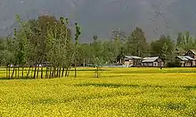 | |
|---|---|---|
| Valleys | ||
| Cities | ||
| Towns |
| |
| Rivers | ||
| Glaciers | ||
| Lakes | ||
| Mountains | ||
| Hill stations and Mughal gardens | ||
| Protected Areas | ||
| See also | ||