Shopian
Shopian or Shupiyan is an apple town and administrative division of the Shopian district, located in southern part of Kashmir Valley, of Jammu and Kashmir, India.[2][3]
Shopian (Shupiyan)
شوپیان | |
|---|---|
town | |
 Shopian (Shupiyan) Location in Jammu and Kashmir, India  Shopian (Shupiyan) Shopian (Shupiyan) (India) | |
| Coordinates: 33.72°N 74.83°E | |
| Country | |
| Union territory | Jammu and Kashmir[1] |
| District | Shopian |
| Government | |
| • Type | District Magistrate - Presidential Rule |
| Area | |
| • Total | 412.87 km2 (159.41 sq mi) |
| Elevation | 2,057 m (6,749 ft) |
| Population (2011) | |
| • Total | 40,360 |
| • Density | 98/km2 (250/sq mi) |
| Languages | |
| • Official | Kashmiri |
| Time zone | UTC+5:30 (IST) |
| PIN | 192303 |
| Area code(s) | 01933 |
| Vehicle registration | JK22 |
| Sex ratio | 756 ♂/ ♀ |
| Website | shopian |
General
The geologist Frederic Drew stated that Shopian derived its name from a distortion of word shah-payan, i.e. "royal stay". However, the local people hold the view that Shopian was earlier named as "Shin-Van" meaning "snow forest". Shopian is an ancient town of Kashmir and had an importance due to it being situated on the ancient imperial route, commonly known as Mughal Road, which connects Lahore and Srinagar.[4] Shopian was one out of six Wazarat Headquarters in Kashmir from 1872-1892 A.D.[5]
Geography
Shupiyan is located at 33.72°N 74.83°E.[6] It has an average elevation of 2057 metres (6748 feet). It is 45 km from Srinagar.
Demographics
According to 2011 Census of India, Shopian Municipal Committee has population of 16,360 which further extends to 9,319 (males) and 7,041 (females), The average population of the town is 6 persons each house.[7]
Population
According to 2011 Census report, Shopian Town had a population of 12,396. Males constitute 51% of the population and females 49%. Shupiyan has an average literacy rate of 59%, lower than the national average of 59.5%: male literacy is 67%, and female literacy is 51%. In Shupiyan, 11% of the population is under 6 years of age.[8]
Education
In 1988, The Government of J&K established a college namely Government Degree College, Shopian which provides higher education infrastructure to the people of Shopian district. The Govt. Polytechnic college was established recently in the Shopian town, which provides technical engineering diploma level education.
Tourism
People from all around the globe visit the tourist places like Peer Ki Gali which is on a mountain top of Mughal road. Mughal Sarai - this palace is situated on the bank of river which flows on the side of Mughal road. This palace was used by Mughal rulers as their resting place during their travels. Dabjan forests - this place is another tourist place of Shopian, where a spring is present in the middle of Dabjan forest. Famous national park Hirpora Wildlife Sanctuary is situated in the district. The Hirpora Wildlife Sanctuary is an abode to many species of animals including the Himalayan brown bear, Himalayan black bear, musk deer, leopard, Tibetan wolf, Himalayan palm civet and also critically endangered Pir Panjal markhor. Besides, 130 species of birds including the spotted forktail, western tragopan, rock bunting, rufous-breasted accentor, Himalayan woodpecker, blue rock thrush, white-capped redstart, Himalayan griffon, common stonechat and grey wagtail are found in the sanctuary.
Economy
About 89 percent of population are apple fruit growers.
References
- https://www.dailyexcelsior.com/advisor-khan-visits-shopian-takes-stock-of-peoples-grievances/
- "Snowfall in south Kashmir's Shopian". greaterkashmir.com. Greater Kashmir.
- "Shopian - Dc Msme" (PDF). dcmsme.gov.in. Development Commissioner Ministry of Micro, Small & Medium Enterprises.
- Bloeria, Sudhir S. (2000). Pakistan's Insurgency vs India's Security: Tackling Militancy in Kashmir. New Delhi: Manas Publications. p. 172. ISBN 978-81-7049-116-3.
- "Districts of India".
- Falling Rain Genomics, Inc - Shupiyan
- "Shupiyan Population Census 2011 - 2018". census2011.co.in. 2011 Census of India.
- "Shupiyan District Population Census 2011". Census Commission of India.
External links
Places adjacent to Shopian | ||||||||||
|---|---|---|---|---|---|---|---|---|---|---|
| ||||||||||
| Passes | 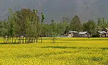 | |
|---|---|---|
| Valleys | ||
| Cities | ||
| Towns |
| |
| Rivers | ||
| Glaciers | ||
| Lakes | ||
| Mountains | ||
| Hill stations and Mughal gardens | ||
| Protected Areas | ||
| See also | ||