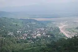
Billawar
Billawar is a town and a notified area committee in Kathua district of the Indian Union Territory of Jammu and Kashmir. Billawar is also a tehsil. It is also called Balaur by locals. Billawar was founded by Raja Bhog Pal in the 7th century A.D.[1] and it remained the capital of Basohli kingdom until the 11th century.[2] The town has ancient monuments, one of which is the Mahabilvakeshwar Temple which is situated in the main market of town Billawar, one of the most revered Shiva temples of the area. The temple was also was known as Hari Hara Temple.
Billawar | |
|---|---|
City | |
 | |
| Nicknames: Balore/Balaur, Billawar | |
 Billawar Location in Jammu and Kashmir, India  Billawar Billawar (India) | |
| Coordinates: 32.62°N 75.62°E | |
| Country | |
| State | Jammu and Kashmir |
| District | Kathua |
| Government | |
| • MLA | Dr. Nirmal singh |
| Elevation | 844 m (2,769 ft) |
| Population (2011) | |
| • Total | 11,916 |
| Languages | |
| • Official | Urdu, Dogri |
| Time zone | UTC+5:30 (IST) |
| PIN | 184204 |
| Vehicle registration | JK08 |
Geography
Billawar is located at 32.62°N 75.62°E.[3] It has an average elevation of 844 m (2,769 ft). Billawar town is situated in the lap of the Shivalik mountains between the banks of the Naz and Bheeni rivulets, approximately 70 km from Dayala Chak on Delhi-Jammu NH-1A. Local places of importance include the Sukrala Devi Temple and an ancient Shiva temple.
History
Pandavas visited Billawar in the last year of their exile and were attracted by Bael or Bilwa trees abundant in the region. The Temple Mahabilwakeshwar was built where Pandavas had worshiped. In Billawar there is an ancient Hanuman's statue built on a rock in the river Naz . According to Dr. Sukhdev Singh Charak, Billawar-Basohli was one of the three parent/original states of the Duggar Group along with Jammu and Poonch.
Raja Bhog Pal, a son of the king of Kullu Valley, founded Basohli and established Billawar as the capital in 765 A.D. after subduing Rana Billo, a feudal chief who once ruled the area. The ruling house was subsequently known as Balouria, deriving from Balor.[4]
Demographics
As of the 2011 India census,[5] Billawar had a population of 11,916. Billawar has two boroughs - old Billawar town and Phinter area. Males constitute 56% of the population and females 44%. Billawar has an average literacy rate of 72%, higher than the national average of 59.5%; with male literacy rate of 78% and female literacy rate of 58%. 12% of the population is under six years of age. The old name of Billawar is "Bilawara". The major religions of this area are Hinduism 88.21% and Islam 9.68%, while some Sikh and Christian communities are also present in small numbers.
Billawar Block (Tehsil) details
The Billawar tehsil (1 of 8 tehsils) of Kathua district has 46 panchayat villages, and numerous others including:[6]
- Aglidhar
- Barota
- Batheri
- Bhaddu
- Chunera
- Dadwara
- Dambra East
- Dambra West
- Derli
- Dewal
- Dehota
- Dhamlar
- Dhanjasdhar
- Dharalta
- Dhar Dugnoo
- Dhar Dugnoo Upper
- Dharamkot
- Dher
- Dungara Lower (Kishanpur)
- Dungara Upper
- Durang
- Hottar
- Kishanpur (Billawar)
- Pallan
- Parnalla
- Phinter
- Thanthu
- Tilla (Ward No. 7)
Connectivity
Billawar is connected to Jammu, Udhampur, Kathua, Basoli, Delhi, Haridwar, Pathankot, Lakhanpur, and Lornoo by regular bus service.
Panjtirthi
It is famous for Shiv Temple.It is Panch Mukhi Lingha situated in the sangam of five tributaries of ujh river.
Billawar
- The Mahabilvakehwar temple of Billawar is a landmark edifice. The Shiva temple is the landmark in the development of art and architecture of the region. It contains the rare Linga image.
- Bala Sundri Mata shrine is a holy place for the locals.
- Famous Sukrala Mata shrine is situated in sukrala village. The temple is visited by thousands of pilgrims every year, mainly from Northern India.
- The Peer Baba, also known as Varun Devata, at the bank of Ujh river is also a place of local religious .
Machhedi
is famous for nature lover. It is Situated at a height of 5000 ft, Machhedi is a ridge blanked with thick cover of Chir pine, Deodar and shrubs. The climate is temperate. It receives winter rainfall from Western disturbances and summer rainfall from monsoons. It is 45km from Billawar . Regular bus service is available from Billawar.
Bhaddu
A prominent town of Billawar Tehsil, was also once the seat of Imperial Power. It was very small state comprising 36 villages. Bhaddu town is situated on Bhinni Naalah, a tributary of Ujh river. The descendants of the Royal family are called Bhadwal Rajputs.
Mankote (Ramkote)
Mankote (Ramkote) is a tehsil separated from Billawar tehsil. It is situated on a hillock on the bank of Basantar Stream on Dhar-Udhampur Road. It was a small state spread over an area of 24 km in length and 15 km in breadth. Mankote was founded by Raja Manak Dev, a contemporary of Raja Narsingh Dev of Jammu (1272-1314 A.D.). The dependents of this clan are known as "Mankotia". It was renamed by Raja Suchet Singh (1822-43 A.D.) as Ramkote.
Sukrala Mata
The most famous shrine in Billawar is Sukrala Devi Shrine, located at a height of 3500 ft on a hillock amidst sylvan surroundings at a distance of 10 km from Billawar and about 75 km from Kathua. The temple a has white-line-coated edifice. Pilgrims to the shrine must scale flights of many steps to reach the temple. According to local belief, the holy shrine is the abode of the goddess Mal Devi, the re-incarnation of Sharda Devi who, according to locals, has manifested herself here in the shape of a Shila (Stone Slab) seated on a Brass Lion with a silver mounted head. Behind the slab is an image of Mahishasur Murdini (re-incarnation of Mahalakshmi) standing on the body of Mahishasur, the Demon King. The Goddess is four-armed, carrying a sword in one of her hands. The shrine is believed to have been built by Madho Singh and exiled Prince of Chamba (Himachal Pradesh). During Navratri the number of pilgrims reaches over 50 thousand.
Tilla
Situated on bank of the rivers Naz and Gurunal, this religious place lies just a few meters adjacent to a Hanuman Stone. There are 320 springs in Gurunal also known as Mini Haridwar. Mandir of Mata Mal Rani is also in Gurunal.
Other tourist Places
Other tourist destinations in the town of Billawar include:
- Sheetla Mata Mandir at Phinter
- Shahidi Chowk Dewal
- Hottar Temple
- Durga Temple of Kohag
- Bhasak Temple Kohag (an ancient temple)
- Narsingh Temple of Kohag Mandli
- Radha Krishna Temple of Upper Mandli
- Goshala at Mandli
- Amar Pinak Shiv Temple
- Sacred Heart Church in Phinter
- Parnala Mandir
- Sheetala Mata Temple
- Bhaddu Shiva Temple
- Sharada Cave at Gura Brota road
- Ringri Mata Temple
- Varundev (Peer Baba) at the bank of river Ujh (Ujhpul)
- Durga Temple of Nagrota Gujroo
- Shani Mandir at Lakhri
- Durga temple at Nagrota
- Panjtirthi Shiv Mandir (lower Dungara)
- Baba Yogdhhyan Mandir at Ramkot
- Murli Manohar Mandir at Ramkot
- Radha Krishna Mandir at Ramkot
- 6 Acres Farm at Mandli
- Narsingh Temple at Galak
- Dharam Raj Temple Galak
Transportation
Bus services are available for Jammu, Kathua, Basoli, Delhi, Pathankot, Katra, Udhampur for long distances, and Matador van services are available for short distances.

References
- Kumar, Raj (2006) [2006]. Paintings and Lifestyles of Jammu Region: From 17th to 19th Century A.D (Reprint ed.). New Delhi: Kalpaz Publications. p. 57. ISBN 9788178355771.
- Kumar, Raj, 1960- (2006). Paintings and lifestyles of Jammu Region : from 17th to 19th century A.D. Delhi: Kalpaz Publications. ISBN 8178354411. OCLC 74991379.CS1 maint: multiple names: authors list (link)
- Falling Rain Genomics, Inc - Billawar
- Kumar, Raj, 1960- (2006). Paintings and lifestyles of Jammu Region : from 17th to 19th century A.D. Delhi: Kalpaz Publications. ISBN 8178354411. OCLC 74991379.CS1 maint: multiple names: authors list (link)
- "Census of India 2001: Data from the 2001 Census, including cities, villages and towns (Provisional)". Census Commission of India. Archived from the original on 16 June 2004. Retrieved 1 November 2008.
- "Reports of National Panchayat Directory: Village Panchayat Names of Billawar, Kathua, Jammu and Kashmir". Ministry of Panchayati Raj, Government of India. Archived from the original on 16 June 2013.