Tangmarg
Tangmarg is a town and tehsil in Baramulla district in Indian union territory of Jammu and Kashmir. In 2014 Tangmarg was granted a sub division and trifurcated into 3 Tehsils (Tangmarg, Kunzer & Karhama), with Sub Divisional Magistrate SDM Office located at Tangmarg. The Tangmarg town is central to more than 100 villages in the vicinity.
Tangmarg | |
|---|---|
Town | |
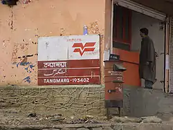 Tangmarg Post Office | |
 Tangmarg Location in Jammu and Kashmir, India  Tangmarg Tangmarg (India) | |
| Coordinates: 34°03′33″N 74°25′28″E | |
| Country | |
| Union territory | Jammu and Kashmir |
| District | Baramulla |
| Time zone | UTC+5:30 (IST) |
| PIN | 193402 |
| Telephone code | +911954 |
Tangmarg has a post office that has been recently modernized, computerized and renovated and there are plans to develop it into a model post office at par with project arrow post offices. There are many hotels and restaurants, everything required by travelling tourists. Tangmarg is 39 km (24 mi) from Srinagar by a two-lane road. Tangmarg has many tourist spots like Drung, Gulmarg, Baderkoot, Zandpal, Gogaldara, Nigli Nullah and Baba Reshi. The name ' Baba Reshi ' is locally given for the great Sufi saint of Kashmir Baba Payam ud Din Reshi' who has a Shrine located around 6 km from Tangmarg. Tangmarg is also known as gate of Gulmarg.Tangmarg is also known as shen kaul which means brook of snow. Tangmarg is also famous for trout fish. This town is known as the gateway of Gulmarg
Geography
The Longitude is 75.36679 and the Latitude is 33.80405.[1] Amongst the prominent villages of this tehsil are Hardushoora, Ferozpora, Pariswani, Chaindil Waingam, Kulhama, Hajibal, Bungam, Reram, Druroo, Hardu Ichloo, Khaipora, Solinda Kunzer, Devbugh, Kralweth Lalpora, Gonipora, Devpora Dardpora, Ganibaba, Pandithpora Bala, Baderkoot, Ratnipora, Ogmuna, Hardu-Aboora, Hariwatnoo, Treran, Katibugh, Chandilora, Qazipora, Gund Dalwash, Tarahama. Tangmarg is famous for fresh cold water, heavy snowfall, and tourism. Tangmarg is a hilly area with most parts covered by lush green forests.
Transport
It is a major stop for buses and other heavy vehicles between Srinagar and Gulmarg or Babareshi. All the vehicles are allowed beyond this point to Gulmarg which is 13 km. Heavy vehicles are not allowed beyond this point during the winter whenever there is a heavy snowfall. This stop is to be taken seriously since there are no more stores on the way to Gulmarg from Tangmarg. A road from Tangmarg to Gogaldara is under construction. This road would connect Tehsil Tangmarg with Tehsil Khag of Badgam district. Another road from Drung to Poonch district of Jammu Division is under consideration by the government.
Access
Tangmarg is located about 39 km (24 mi) from Srinagar. The general approach to the town is through road transport (taxi and bus). Transport is available from Srinagar, Baramulla, Magam, Sopore, Gulmarg and Pattan.The town is also not far from the Mazhama Railway station.
History
The history of Tangmarg dates back to Mughal Era. It was used as a gateway to Gulmarg. Literally from local dialect Tang means Pear and Marg means meadow. There are many pear trees in the vicinity of Tangmarg town scattered in different villages. In september of 2010, several People were killed by Indian Paramilitary forces in Tangmarg market when they were protesting for Freedom and against desecretion of Holy Quran.
Education and Health
A Sub-district Hospital is located at Tangmarg with affiliated Primary Health Centres in all major villages. A Government Degree College was established in 2011-12 at Chandilora. 5 Higher Secondary Schools are situated in Tangmarg including Fazil Kashmiri memorial higher secondary School.
Language
Kashmiri is the predominant language spoken in the villages of Tangmarg, Urdu is second widely spoken language after Kashmiri, Pahari is another important language spoken in area whereas English language is also spoken by educated class and those who deal with the tourism industry. Gojri also has many speakers.
References
- https://indiamapia.com › Baramulla Tangmarg Pin Code, Tangmarg, Baramulla Map, Latitude and ...