Robertson County, Kentucky
Robertson County is a county located in the U.S. Commonwealth of Kentucky. As of the 2010 census, the population was 2,282.[1] Its county seat is Mount Olivet.[2] The county is named for George Robertson, a Kentucky Congressman from 1817 to 1821. It is Kentucky's smallest county by total area and the least populous.
Robertson County | |
|---|---|
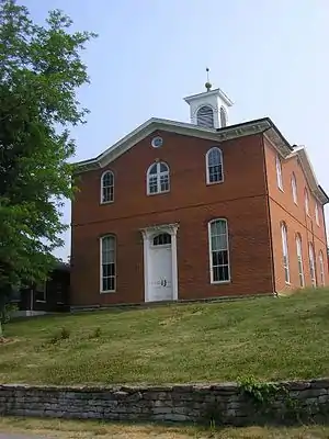 Robertson County Courthouse in Mount Olivet | |
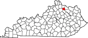 Location within the U.S. state of Kentucky | |
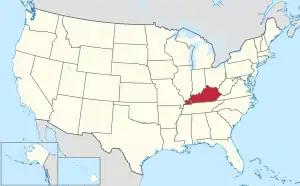 Kentucky's location within the U.S. | |
| Coordinates: 38°31′N 84°03′W | |
| Country | |
| State | |
| Founded | 1867 |
| Named for | George Robertson |
| Seat | Mount Olivet |
| Largest city | Mount Olivet |
| Area | |
| • Total | 100 sq mi (300 km2) |
| • Land | 100 sq mi (300 km2) |
| • Water | 0.2 sq mi (0.5 km2) 0.2% |
| Population (2010) | |
| • Total | 2,282 |
| • Estimate (2018) | 2,135 |
| • Density | 23/sq mi (8.8/km2) |
| Time zone | UTC−5 (Eastern) |
| • Summer (DST) | UTC−4 (EDT) |
| Congressional district | 6th |
| Website | www |
History
Robertson County was formed on February 11, 1867 from portions of Bracken County, Harrison County, Mason County and Nicholas County. It was named after George Robertson, a judge and member of Congress.[3]
Politics
| Year | Republican | Democratic | Third parties |
|---|---|---|---|
| 2020 | 77.1% 884 | 22.1% 253 | 0.8% 9 |
| 2016 | 74.9% 759 | 21.9% 222 | 3.2% 32 |
| 2012 | 61.9% 579 | 36.4% 340 | 1.7% 16 |
| 2008 | 52.5% 533 | 44.4% 451 | 3.1% 31 |
| 2004 | 61.5% 670 | 37.9% 413 | 0.6% 7 |
| 2000 | 63.1% 630 | 34.2% 341 | 2.7% 27 |
| 1996 | 43.3% 368 | 42.4% 360 | 14.4% 122 |
| 1992 | 34.8% 329 | 46.5% 439 | 18.7% 177 |
| 1988 | 49.4% 511 | 49.8% 515 | 0.9% 9 |
| 1984 | 54.4% 567 | 44.8% 467 | 0.9% 9 |
| 1980 | 41.6% 416 | 56.3% 562 | 2.1% 21 |
| 1976 | 33.2% 275 | 65.9% 546 | 0.9% 7 |
| 1972 | 51.0% 456 | 47.1% 421 | 1.9% 17 |
| 1968 | 41.2% 416 | 40.2% 406 | 18.7% 189 |
| 1964 | 34.2% 383 | 65.6% 734 | 0.2% 2 |
| 1960 | 47.7% 594 | 52.3% 652 | 0.0% 0 |
| 1956 | 43.7% 617 | 56.2% 793 | 0.1% 2 |
| 1952 | 42.9% 623 | 57.0% 827 | 0.1% 1 |
| 1948 | 33.4% 442 | 65.4% 864 | 1.2% 16 |
| 1944 | 39.4% 556 | 60.5% 855 | 0.1% 2 |
| 1940 | 40.9% 578 | 58.6% 829 | 0.5% 7 |
| 1936 | 35.5% 498 | 63.9% 897 | 0.6% 8 |
| 1932 | 33.5% 538 | 65.8% 1,056 | 0.6% 10 |
| 1928 | 53.7% 742 | 46.3% 640 | 0.0% 0 |
| 1924 | 41.9% 498 | 57.1% 680 | 1.0% 12 |
| 1920 | 39.7% 623 | 59.9% 940 | 0.5% 7 |
| 1916 | 38.3% 415 | 61.2% 663 | 0.5% 5 |
| 1912 | 15.9% 158 | 57.5% 570 | 26.5% 263 |
Geography
According to the U.S. Census Bureau, the county has a total area of 100 square miles (260 km2), of which 100 square miles (260 km2) is land and 0.2 square miles (0.52 km2) (0.2%) is water.[5] It is the smallest county by area in Kentucky.[6]
Adjacent counties
- Bracken County (north)
- Mason County (northeast)
- Fleming County (southeast)
- Nicholas County (south)
- Harrison County (west)
Demographics
| Historical population | |||
|---|---|---|---|
| Census | Pop. | %± | |
| 1870 | 5,399 | — | |
| 1880 | 5,814 | 7.7% | |
| 1890 | 4,684 | −19.4% | |
| 1900 | 4,900 | 4.6% | |
| 1910 | 4,121 | −15.9% | |
| 1920 | 3,871 | −6.1% | |
| 1930 | 3,344 | −13.6% | |
| 1940 | 3,419 | 2.2% | |
| 1950 | 2,881 | −15.7% | |
| 1960 | 2,443 | −15.2% | |
| 1970 | 2,163 | −11.5% | |
| 1980 | 2,265 | 4.7% | |
| 1990 | 2,124 | −6.2% | |
| 2000 | 2,266 | 6.7% | |
| 2010 | 2,282 | 0.7% | |
| 2018 (est.) | 2,135 | [7] | −6.4% |
| U.S. Decennial Census[8] 1790-1960[9] 1900-1990[10] 1990-2000[11] 2010-2013[1] | |||
At the 2000 census there were 2,266 people, 866 households, and 621 families in the county, making it the least populated county in the state. The population density was 23 per square mile (8.9/km2). There were 1,034 housing units at an average density of 10 per square mile (3.9/km2). The racial makeup of the county was 98.63% White, 0.04% Black or African American, 0.04% Native American, 0.22% from other races, and 1.06% from two or more races. 0.93% of the population were Hispanic or Latino of any race.[12] Of the 866 households 31.10% had children under the age of 18 living with them, 57.60% were married couples living together, 9.10% had a female householder with no husband present, and 28.20% were non-families. 24.70% of households were one person and 11.10% were one person aged 65 or older. The average household size was 2.54 and the average family size was 3.00.
The age distribution was 23.80% under the age of 18, 6.70% from 18 to 24, 27.10% from 25 to 44, 25.50% from 45 to 64, and 16.90% 65 or older. The median age was 40 years. For every 100 females there were 94.80 males. For every 100 females age 18 and over, there were 92.50 males.
The median household income was $30,581 and the median family income was $35,521. Males had a median income of $27,656 versus $20,476 for females. The per capita income for the county was $13,404. About 17.50% of families and 22.20% of the population were below the poverty line, including 30.30% of those under age 18 and 24.10% of those age 65 or over.
Communities
- Kentontown
- Mount Olivet (county seat)
- Piqua
References
- "State & County QuickFacts". United States Census Bureau. Retrieved March 6, 2014.
- "Find a County". National Association of Counties. Retrieved 2011-06-07.
- The Register of the Kentucky State Historical Society, Volume 1. Kentucky State Historical Society. 1903. pp. 36.
- Leip, David. "Dave Leip's Atlas of U.S. Presidential Elections". uselectionatlas.org. Retrieved 2018-07-05.
- "2010 Census Gazetteer Files". United States Census Bureau. August 22, 2012. Archived from the original on August 12, 2014. Retrieved August 19, 2014.
- http://www.uky.edu/KentuckyAtlas/kentucky-counties.html
- "Population and Housing Unit Estimates". Retrieved July 29, 2019.
- "U.S. Decennial Census". United States Census Bureau. Retrieved August 19, 2014.
- "Historical Census Browser". University of Virginia Library. Retrieved August 19, 2014.
- "Population of Counties by Decennial Census: 1900 to 1990". United States Census Bureau. Retrieved August 19, 2014.
- "Census 2000 PHC-T-4. Ranking Tables for Counties: 1990 and 2000" (PDF). United States Census Bureau. Retrieved August 19, 2014.
- "U.S. Census website". United States Census Bureau. Retrieved 2008-01-31.
Municipalities and communities of Robertson County, Kentucky, United States | ||
|---|---|---|
| Cities | Location of Robertson County, Kentucky | |
| Unincorporated communities |
| |
| Footnotes | ‡This populated place also has portions in an adjacent county or counties | |
| ||
| Authority control |
|---|