Warren County, Kentucky
Warren County is a county located in the south central portion of the U.S. state of Kentucky. As of 2019, the population was 132,896,[1] making it the fifth-most populous county in Kentucky. The county seat is Bowling Green.[2] Warren County is now classified as a wet county after voters approved the measure in 2018. The measure became law in January 2019 that allows alcohol to be sold county wide.[3]
Warren County | |
|---|---|
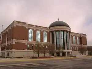 Warren County Justice Center in Bowling Green | |
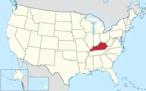
 Location within the U.S. state of Kentucky | |
 Kentucky's location within the U.S. | |
| Coordinates: 36°59′N 86°25′W | |
| Country | |
| State | |
| Founded | December 19, 1796 |
| Named for | Joseph Warren |
| Seat | Bowling Green |
| Largest city | Bowling Green |
| Area | |
| • Total | 548 sq mi (1,420 km2) |
| • Land | 542 sq mi (1,400 km2) |
| • Water | 6.0 sq mi (16 km2) 1.1% |
| Population (2010) | |
| • Total | 113,792 |
| • Estimate (2019) | 132,896 |
| • Density | 210/sq mi (80/km2) |
| Time zone | UTC−6 (Central) |
| • Summer (DST) | UTC−5 (CDT) |
| Congressional district | 2nd |
| Website | www |
Warren County is included in the Bowling Green, KY Metropolitan Statistical Area. It is located in the Pennyroyal Plateau and Western Coal Fields regions.[4]
History
Warren County was the location of several Native American villages and ancient burial mounds constructed by earlier cultures. The first white men to enter the area were the long hunters in the 1770s.[5] General Elijah Covington was among the first landowners.[6] McFadden's Station, one of the earliest settlements, was established in 1785 by Andrew McFadden/McFadin on the northern bank of the Barren River at the Cumberland Trace.[7]
Warren County became the 23rd county of Kentucky in 1796, from a section of Logan County.[8][9] It was named after General Joseph Warren of the Revolutionary War. He dispatched William Dawes and Paul Revere on their famous midnight ride to warn residents of the approaching British troops. He was also a hero of the Battle of Bunker Hill.[10]
Through the riverboat trade, Warren County thrived in the agricultural market. In 1859, the Louisville and Nashville Railroad (currently CSX Transportation) was laid through the county.[5]
During the Civil War, most residents are said to have favored the Union.[5][11] Because of its strategic value Warren County was occupied by Confederate forces in September 1861. It was occupied in turn by the Union Army on February 14, 1862, following the Confederate retreat to Tennessee.[5] During the Confederate withdrawal, they destroyed railroad bridges in Barren County, the Bowling Green train depot and other railroad buildings to hinder Union pursuit.[12]
The completion of Interstate 65 and Green River Parkway, later renamed the William H. Natcher Parkway, (and in 2019 was renamed as the I-165,) in the 1960s and 1970s, brought an industrial boom that transformed the farm-oriented county into a more urban one.[5]
In 1997, Bowling Green became a Tree City USA, sponsored by the National Arbor Day Foundation.[13]
Geography
According to the U.S. Census Bureau, the county has a total area of 548 square miles (1,420 km2), of which 542 square miles (1,400 km2) is land and 6.0 square miles (16 km2) (1.1%) is water.[14]
Geographic features
The Green River forms the northern boundary of the county, and was a means of transportation for settlers. Tributaries of the Green River that flow through Warren County are the Barren and Gasper rivers, Drake's and Jennings creeks and Bay's Fork. In the north the land is possibly the most rugged, since it lies between the Green and Barren rivers, with very tall ridges near Riverside and Richardsville. The major drainage in Warren county is Barren River, which flows through Bowling Green and is surrounded by steep ridges in some areas. Several sizable hills rise in Bowling Green proper. They were favored for forts and other development: a reservoir, hospital, and Civil War fort were built on one; much of Western Kentucky University's campus on another; Hobson Grove, a historic Italian Renaissance style civil war era plantation estate on another; and a second civil war fort on another. In the east the land is rolling (much like central Kentucky's landscape) near Drakes Creek. The land in the south and southwest of the county is predominantly flat. In the western side of the county, the land is hilly with steep ridges and rocky and cliff-ridden near Gasper River. Shanty Hollow Lake is in the northwest corner of the county.
The flat elevated areas in the west and the flatland in the south and southwest have soil that is fertile and supports tobacco, hay, corn and soybean crop production. The rest of the land is predominantly clay soil; it is rocky and not very suitable for agriculture. Many residents rear livestock and horses, or hunt in these areas.
Major highways
Adjacent counties
- Butler County - northwest
- Edmonson County - northeast
- Barren County - east
- Allen County - southeast
- Simpson County - south
- Logan County - southwest
Demographics
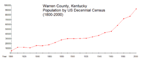
| Historical population | |||
|---|---|---|---|
| Census | Pop. | %± | |
| 1800 | 4,686 | — | |
| 1810 | 11,937 | 154.7% | |
| 1820 | 11,776 | −1.3% | |
| 1830 | 10,949 | −7.0% | |
| 1840 | 15,446 | 41.1% | |
| 1850 | 15,123 | −2.1% | |
| 1860 | 17,320 | 14.5% | |
| 1870 | 21,742 | 25.5% | |
| 1880 | 27,531 | 26.6% | |
| 1890 | 30,158 | 9.5% | |
| 1900 | 29,970 | −0.6% | |
| 1910 | 30,579 | 2.0% | |
| 1920 | 30,858 | 0.9% | |
| 1930 | 33,676 | 9.1% | |
| 1940 | 36,631 | 8.8% | |
| 1950 | 42,758 | 16.7% | |
| 1960 | 45,491 | 6.4% | |
| 1970 | 57,884 | 27.2% | |
| 1980 | 71,828 | 24.1% | |
| 1990 | 76,673 | 6.7% | |
| 2000 | 92,522 | 20.7% | |
| 2010 | 113,792 | 23.0% | |
| 2019 (est.) | 132,896 | [15] | 16.8% |
| U.S. Decennial Census[16] 1790-1960[17] 1900-1990[18] 1990-2000[19] 2010-2019[20] | |||
At the 2000 census,[21] there were 92,522 people, 35,365 households and 23,411 families residing in the county. The population density was 170 per square mile (66/km2). There were 38,350 housing units at an average density of 70 per square mile (27/km2). The racial makeup of the county was 86.98% White, 8.58% Black or African American, 0.24% Native American, 1.35% Asian, 0.08% Pacific Islander, 1.33% from other races, and 1.45% from two or more races. 2.67% of the population were Hispanic or Latino of any race.
There were 35,365 households, of which 31.40% had children under the age of 18 living with them, 51.40% were married couples living together, 11.20% had a female householder with no husband present, and 33.80% were non-families. 26.10% of all households were made up of individuals, and 8.30% had someone living alone who was 65 years of age or older. The average household size was 2.46 and the average family size was 2.97.
The age distribution was 23.10% under the age of 18, 16.20% from 18 to 24, 29.10% from 25 to 44, 21.10% from 45 to 64, and 10.50% who were 65 years of age or older. The median age was 32 years. For every 100 females, there were 96.20 males. For every 100 females age 18 and over, there were 93.00 males.
The median household income was $36,151, and the median family income was $45,142. Males had a median income of $32,063 versus $22,777 for females. The per capita income for the county was $18,847. About 10.80% of families and 15.40% of the population were below the poverty line, including 17.80% of those under age 18 and 13.80% of those age 65 or over.
Politics
| Year | Republican | Democratic | Third parties |
|---|---|---|---|
| 2020 | 57.4% 31,791 | 40.6% 22,479 | 2.0% 1,131 |
| 2016 | 59.2% 28,673 | 35.0% 16,966 | 5.8% 2,815 |
| 2012 | 60.1% 26,384 | 38.3% 16,805 | 1.6% 714 |
| 2008 | 58.9% 25,993 | 40.0% 17,669 | 1.1% 483 |
| 2004 | 63.2% 25,100 | 36.1% 14,326 | 0.7% 285 |
| 2000 | 61.4% 20,235 | 36.9% 12,180 | 1.7% 560 |
| 1996 | 53.7% 15,784 | 39.6% 11,642 | 6.7% 1,980 |
| 1992 | 49.3% 14,748 | 38.6% 11,529 | 12.1% 3,619 |
| 1988 | 63.1% 16,703 | 36.6% 9,684 | 0.4% 97 |
| 1984 | 66.9% 16,167 | 32.8% 7,937 | 0.3% 74 |
| 1980 | 53.9% 12,184 | 42.7% 9,643 | 3.4% 777 |
| 1976 | 48.9% 9,439 | 50.1% 9,657 | 1.0% 195 |
| 1972 | 66.8% 12,481 | 31.8% 5,934 | 1.5% 276 |
| 1968 | 45.8% 8,084 | 29.4% 5,200 | 24.8% 4,381 |
| 1964 | 37.4% 5,915 | 62.5% 9,887 | 0.2% 29 |
| 1960 | 54.9% 9,074 | 45.1% 7,457 | 0.0% 0 |
| 1956 | 53.1% 8,123 | 46.7% 7,143 | 0.3% 44 |
| 1952 | 50.4% 7,267 | 49.3% 7,106 | 0.2% 34 |
| 1948 | 33.5% 3,919 | 57.9% 6,768 | 8.6% 1,004 |
| 1944 | 39.5% 4,944 | 60.2% 7,528 | 0.3% 37 |
| 1940 | 35.6% 4,195 | 64.1% 7,569 | 0.3% 36 |
| 1936 | 34.7% 4,347 | 64.8% 8,113 | 0.4% 54 |
| 1932 | 33.7% 4,569 | 65.8% 8,932 | 0.6% 77 |
| 1928 | 60.9% 7,931 | 39.1% 5,092 | 0.0% 1 |
| 1924 | 44.1% 5,634 | 54.9% 7,005 | 1.0% 132 |
| 1920 | 43.5% 5,474 | 55.6% 7,010 | 0.9% 115 |
| 1916 | 41.2% 3,002 | 58.0% 4,228 | 0.9% 65 |
| 1912 | 20.3% 1,342 | 52.1% 3,447 | 27.6% 1,825 |
| 1908 | 43.1% 2,929 | 55.1% 3,742 | 1.8% 124 |
| 1904 | 42.8% 2,737 | 54.4% 3,484 | 2.8% 181 |
| 1900 | 45.3% 2,928 | 53.5% 3,455 | 1.2% 77 |
| 1896 | 42.0% 2,866 | 54.4% 3,716 | 3.6% 248 |
| 1892 | 38.7% 2,053 | 54.0% 2,867 | 7.3% 387 |
| 1888 | 41.3% 2,590 | 57.2% 3,587 | 1.6% 99 |
| 1884 | 38.3% 1,866 | 60.3% 2,937 | 1.4% 66 |
| 1880 | 40.5% 1,703 | 53.6% 2,253 | 5.8% 245 |
Education
Two public school districts operate in the county:
- Warren County Public Schools, which serves most of the county.[24][25][26]
- Bowling Green Independent Schools, which serves most of the city of Bowling Green.[27]
There are also private schools including
- Anchored Christian School
- Bowling Green Christian Academy
- Foundation Christian Academy
- St. Joseph School, a private Catholic school.
- Carol Martin Gatton Academy of Mathematics and Science in Kentucky
Elementary schools
- Alvaton
- Briarwood
- Bristow
- Cumberland Trace
- Lost River
- Jody Richards
- North Warren
- Oakland
- Plano
- Rich Pond
- Richardsville
- Rockfield
- Warren
- William H. Natcher
Middle schools
- Drakes Creek
- Henry F. Moss
- Warren East
- South Warren Middle School
High schools
- Greenwood
- Light House Academy
- Warren Central
- Warren East
- South Warren High School
- GEO International High School
Elementary schools
- Dishman McGinnis
- Parker Bennett Curry
- Potter Gray
- T. C. Cherry
- W. R. McNeill
Junior high schools
High schools
- Eleventh Street
- Bowling Green High School
Colleges and universities
Public Library System
Attractions
- Beech Bend Park - roller coasters, waterpark, raceway
- Chevrolet Corvette and XLR Assembly Plant - daily tours
- Eloise B. Houchens Center - Greek Revival-style mansion built in 1904 by a former Bowling Green mayor
- Fort Webb Historic Park - preserved Civil War site
- Historic Railpark at the L&N Depot - two floor train museum with 6 restored railcars inside a 1925 depot.
- Kentucky Museum and Library - exhibits of Kentucky artifacts, located on Western Kentucky University campus
- Lost River Cave and Valley - location of the shortest and deepest river in the world, once a hideout for Jesse James and company
- National Corvette Museum - exhibits of the models of the Chevrolet Corvette since 1953
- Riverview at Hobson Grove - preserved mansion overlooking Barren River built from the late 1850s until 1872
Communities
Cities
- Bowling Green (county seat)
- Oakland
- Plum Springs
- Smiths Grove
- Woodburn
Census-designated place
Northeast Warren
- Anna
- Bristow
- Girkin
- Glenmore
- Gotts
- Hydro
- Kepler
- Martinsville
- Polkville
- Pondsville
- Richardsville
- Riverside
- Sunnyside
- Three Forks
- Tuckertown
Southwest Warren
- Alvaton
- Blue Level
- Boyce
- Browning
- Claypool
- Drake
- Greenhill
- Guy
- Hadley
- Hardcastle
- Lost River
- Matlock
- Memphis Junction
- Petros
- Rich Pond
- Rockfield
- Rockland
- Shawnee Estates
- Springhill
- Three Springs
References
- "Archived copy". Archived from the original on 2016-01-10. Retrieved 2017-12-07.CS1 maint: archived copy as title (link)
- "Find a County". National Association of Counties. Retrieved 2011-06-07.
- "Wet & Dry Counties in Kentucky" (PDF). Kentucky Office of Alcoholic Beverage Control. Archived from the original (PDF) on March 15, 2007. Retrieved March 21, 2007.
- "Warren County, Kentucky - Kentucky Atlas and Gazetteer". www.uky.edu.
- Hoffman, Dr. Wayne (1989). "The History of Bowling Green and Warren County" (PDF).
- Hay, Melba Porter; Wells, Dianne; Jr, Thomas H. Appleton; Appleton, Thomas H. (2002-04-06). Roadside History: A Guide to Kentucky Highway Markers. University Press of Kentucky. ISBN 9780916968298.
- "McFadin's Station - Kentucky Historical Markers on Waymarking.com". www.waymarking.com. Retrieved 2019-03-15.
- "Warren County". The Kentucky Encyclopedia. 2000. Retrieved August 23, 2014.
- Collins, Lewis (1882). Collins' Historical Sketches of Kentucky: History of Kentucky, Volume 2. Collins & Company. p. 26.
- Martin, McKenzie. "Warren County". ExploreKYHistory. Retrieved 2019-03-15.
- "Civil War Dispatch - Western Kentucky University". www.wkms.org. Retrieved 2019-03-15.
- Martin, McKenzie. "Civil War Occupations". ExploreKYHistory. Retrieved 2019-03-15.
- "Tree Cities". www.arborday.org. Retrieved 2019-03-13.
- "2010 Census Gazetteer Files". United States Census Bureau. August 22, 2012. Archived from the original on August 12, 2014. Retrieved August 20, 2014.
- "Population and Housing Unit Estimates". Retrieved May 21, 2020.
- "U.S. Decennial Census". United States Census Bureau. Retrieved August 20, 2014.
- "Historical Census Browser". University of Virginia Library. Retrieved August 20, 2014.
- "Population of Counties by Decennial Census: 1900 to 1990". United States Census Bureau. Retrieved August 20, 2014.
- "Census 2000 PHC-T-4. Ranking Tables for Counties: 1990 and 2000" (PDF). United States Census Bureau. Retrieved August 20, 2014.
- "State & County QuickFacts". United States Census Bureau. Retrieved March 6, 2014.
- "U.S. Census website". United States Census Bureau. Retrieved 2008-01-31.
- Leip, David. "Dave Leip's Atlas of U.S. Presidential Elections". uselectionatlas.org. Retrieved 2018-07-06.
- http://geoelections.free.fr/. Retrieved January 13, 2021. Missing or empty
|title=(help) - Warren County Public Schools - Elementary School List Archived 2005-02-05 at the Wayback Machine
- Warren County Public Schools - Middle School List Archived 2005-02-05 at the Wayback Machine
- Warren County Public Schools - High School List Archived 2005-05-11 at the Wayback Machine
- Bowling Green Independent Schools Archived 2005-07-28 at the Wayback Machine
External links
- Warren County Government
- Warren County Public Library
- Beech Bend Park - Official Page
- Bowling Green Daily News
- Corvette Museum
- Corvette Bowling Green Plant
- KYGenWeb Project, Warren County
- Lost River Cave - Official Page
- The Kentucky Museum
Municipalities and communities of Warren County, Kentucky, United States | ||
|---|---|---|
| Cities | Location of Warren County, Kentucky | |
| CDP | ||
| Other unincorporated communities | ||
| ||
| Principal city | _Metro.png.webp) | |
|---|---|---|
| Other municipalities | ||
| Counties | ||
| Authority control |
|---|