Shire of Mundaring
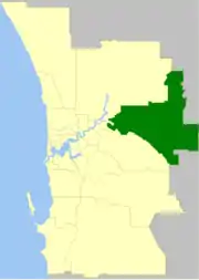
The Shire of Mundaring is a local government area in eastern metropolitan Perth, the capital of Western Australia. The Shire covers an area of 645 square kilometres (249 sq mi) and had a population of approximately 38,000 as at the 2016 Census.
| Shire of Mundaring Western Australia | |||||||||||||||
|---|---|---|---|---|---|---|---|---|---|---|---|---|---|---|---|
 | |||||||||||||||
| Population | 38,157 (2016 census)[1] | ||||||||||||||
| • Density | 59.167/km2 (153.243/sq mi) | ||||||||||||||
| Established | 1903 | ||||||||||||||
| Area | 644.9 km2 (249.0 sq mi) | ||||||||||||||
| Mayor | John Daw | ||||||||||||||
| Council seat | Mundaring | ||||||||||||||
| Region | Eastern Metropolitan Perth Darling Scarp | ||||||||||||||
| State electorate(s) | Darling Range, Kalamunda, Midland, Swan Hills | ||||||||||||||
| Federal Division(s) | Hasluck, Pearce | ||||||||||||||
| Website | Shire of Mundaring | ||||||||||||||
| |||||||||||||||
History
The Greenmount Road District was created on 17 April 1903. On 29 March 1934, it was renamed the Mundaring Road District. On 1 July 1961, it became the Shire of Mundaring following the passage of the Local Government Act 1960, which reformed all remaining road districts into shires.[2]
Statistics
Mundaring Shire has published the following statistics for the period 1994-2006:[3]
- Population: 35,097
- Area: 643.32 km²
- Rateable area: 205.91 km²
- Rateable properties: 13,600
- Revenue: A$17.4M
- Vested reserves: 104.60 km²
- Forests and National Parks: 238.30 km²
Wards
The shire is divided into four wards.
- West Ward (three councillors)
- South Ward (three councillors)
- Central Ward (three councillors)
- East Ward (three councillors)
National Parks
The Shire contains three national parks and numerous nature reserves:
Trails
The Shire is recognised for its natural environment and has numerous walk and ride trails:
- Bibbulmun Track
- C Y O'Connor Trail
- Eagle View Walk Trail
- Forsyths Mill Mountain Bike Track
- Kep Track
- Lake Leschenaultia Trails
- Munda Biddi Trail
- Railway Reserves Heritage Trail
- Weir View Walk
Suburbs and localities
Population
|
|
Presidents and chairmen
Heritage-listed places
As of 2020, 143 places are heritage-listed in the Shire of Mundaring,[4] of which 24 are on the State Register of Heritage Places, among them John Forrest National Park, Lake Leschenaultia and the Swan View Tunnel.[5]
See also
References
- Australian Bureau of Statistics (27 June 2017). "Mundaring (S)". 2016 Census QuickStats. Retrieved 26 November 2017.

- "Municipality Boundary Amendments Register" (PDF). Western Australian Electoral Distribution Commission. Retrieved 11 January 2020.
- Mundaring Shire Council. "Population & Area". Archived from the original on 19 February 2006. Retrieved 1 April 2006.
- "Shire of Mundaring Heritage Places". inherit.stateheritage.wa.gov.au. Heritage Council of Western Australia. Retrieved 2 April 2020.
- "Shire of Mundaring State Register of Heritage Places". inherit.stateheritage.wa.gov.au. Heritage Council of Western Australia. Retrieved 2 April 2020.
