City of Melville
The City of Melville is a local government area in the southern suburbs of the Western Australian capital city of Perth, east of the port city of Fremantle and about 12 kilometres (7.5 mi) south of Perth's central business district. The City covers an area of 52.73 square kilometres (20.36 sq mi) and had a population of about 98,000 as at the 2016 Census.
| City of Melville Western Australia | |||||||||||||||
|---|---|---|---|---|---|---|---|---|---|---|---|---|---|---|---|
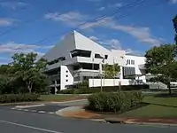 City of Melville Council Offices | |||||||||||||||
| Population |
| ||||||||||||||
| • Density | 1,860.10/km2 (4,817.6/sq mi) | ||||||||||||||
| Established | 1900 | ||||||||||||||
| Area | 52.73 km2 (20.4 sq mi) | ||||||||||||||
| Mayor | George Gear | ||||||||||||||
| Council seat | Booragoon | ||||||||||||||
| Region | South Metropolitan Perth | ||||||||||||||
| State electorate(s) | Willagee, Alfred Cove, Bateman, Fremantle, Riverton | ||||||||||||||
| Federal Division(s) | Tangney, Fremantle | ||||||||||||||
 | |||||||||||||||
| Website | City of Melville | ||||||||||||||
| |||||||||||||||
History
Melville was originally established on 14 December 1900 as the East Fremantle Road District under the Roads Boards Act 1871. It was renamed the Melville Road District six months later on 14 June 1901. On 20 July 1923, it received a large amount of land from Jandakot Road District when that entity was abolished.[3]
On 1 July 1961, it became the Shire of Melville following the enactment of the Local Government Act 1960, which reformed all remaining road districts into shires. It was granted town status as the Town of Melville on 28 September 1962,[4] and assumed its current name when it was granted city status on 3 May 1968.[5]
The City of Melville maintains 463 km of roads and 2.10 km² of parks and gardens.
Wards
The City is divided into six wards, each represented by two councillors. Each councillor serves a four-year term, and half-elections are held every two years. The mayor is directly elected.
- Applecross-Mount Pleasant Ward
- Bateman-Kardinya-Murdoch Ward
- Bicton-Attadale-Alfred Cove Ward
- Bull Creek-Leeming Ward
- Central Ward
- Palmyra-Melville-Willagee Ward
Suburbs
- Alfred Cove
- Applecross
- Ardross
- Attadale
- Bateman
- Bicton
- Booragoon
- Brentwood
- Bull Creek
- Kardinya
- Leeming *
- Melville
- Mount Pleasant
- Murdoch
- Myaree
- Palmyra
- Willagee
- Winthrop
(* indicates suburb partially located within City)
Indigenous sites of significance
There are several significant Noongar sites within the City of Melville precinct.[6][7]
- Niergarup
- Quaada Gabee
- Jenalup
- Dyoondalup
- Marradungup
- Wireless Hill
Population
|
|
Mayors
Heritage-listed places
As of 2020, 172 places are heritage-listed in the City of Melville,[8] of which 24 are on the State Register of Heritage Places, among them Canning Bridge and Wireless Hill Park.[9]
Sports and recreation
The City is home to 23 active reserves, 100+ passive reserves and two leisure centres featuring indoor courts and 50m and 25m indoor heated pools. The City caters for a diverse number of sporting and recreation codes, including, but not limited to:
- Archery
- Athletics
- Australian Football
- Baseball/Softball/Tee-ball
- BMX
- Bowls
- Cricket
- Gaelic Football
- Golf
- Hockey
- Homing Pigeon
- Netball
- Personal Training/Fitness Groups
- Rowing
- Rugby League and Union
- Soccer/Football
- Squash
- Swimming
- Synchronised Swimming
- Tennis
- Touch Football
- Triathlon Training
- Walking/Running
- Water Polo
The City maintains a Community Information Directory which can be used to find locations and contact details for 70+ inclusive sporting and recreation clubs operating within the City of Melville.
Some of the clubs include:
References
Notes
- Australian Bureau of Statistics (27 June 2017). "Melville (C)". 2016 Census QuickStats. Retrieved 26 November 2017.

- "3218.0 – Regional Population Growth, Australia, 2017-18". Australian Bureau of Statistics. 27 March 2019. Retrieved 31 December 2019. Estimated resident population (ERP) at 30 June 2018.
- "Municipality Boundary Amendments Register" (PDF). Western Australian Electoral Distribution Commission. Retrieved 11 January 2020.
- "Local Government Act, 1960. Declaration as a Town. Provisions Concerning Elections. (per L.G. 433/62)". Western Australia Government Gazette. 28 September 1962. p. 1962:2680–2681.
- "Local Government Act, 1960–1967. Order in Council". Western Australia Government Gazette. 3 May 1968. p. 1968:1245.
- "Aboriginal History in the City of Melville". City of Melville. Archived from the original on 4 March 2016. Retrieved 19 July 2015.
- "Sites of Cultural Significance in the City of Melville". City of Melville. Archived from the original on 4 March 2016. Retrieved 19 July 2015.
- "City of Melville Heritage Places". inherit.stateheritage.wa.gov.au. Heritage Council of Western Australia. Retrieved 19 February 2020.
- "City of Melville State Register of Heritage Places". inherit.stateheritage.wa.gov.au. Heritage Council of Western Australia. Retrieved 19 February 2020.