National Register of Historic Places listings in Sweetwater County, Wyoming
This is a list of the National Register of Historic Places listings in Sweetwater County, Wyoming.
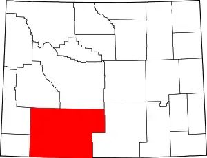
Location of Sweetwater County in Wyoming
This is intended to be a complete list of the properties and districts on the National Register of Historic Places in Sweetwater County, Wyoming, United States. The locations of National Register properties and districts for which the latitude and longitude coordinates are included below, may be seen in a map.[1]
There are 35 properties and districts listed on the National Register in the county, 1 of which is a National Historic Landmark.
- This National Park Service list is complete through NPS recent listings posted January 29, 2021.[2]
| Albany - Big Horn - Campbell - Carbon - Converse - Crook - Fremont - Goshen - Hot Springs - Johnson - Laramie - Lincoln - Natrona - Niobrara - Park - Platte - Sheridan - Sublette - Sweetwater - Teton - Uinta - Washakie - Weston |
Current listings
| [3] | Name on the Register | Image | Date listed[4] | Location | City or town | Description |
|---|---|---|---|---|---|---|
| 1 | Araphoe and Lost Creek Site (48SW4882) | March 12, 1986 (#86000352) |
Address restricted |
Hadsell Cabin | ||
| 2 | Bairoil Town Hall | 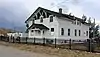 Bairoil Town Hall |
November 30, 2015 (#15000858) |
505 Antelope Dr. 42°14′34″N 107°33′35″W |
Bairoil | |
| 3 | City Hall | 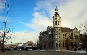 City Hall |
May 15, 1980 (#80004053) |
4th and B Sts. 41°35′06″N 109°13′14″W |
Rock Springs | |
| 4 | Dean Decker Site (48FR916; 48SW541) | March 12, 1986 (#86000354) |
Address restricted |
Honeycomb Buttes | Extends into Fremont County | |
| 5 | Downtown Rock Springs Historic District | 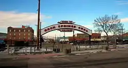 Downtown Rock Springs Historic District |
January 19, 1994 (#93001492) |
Roughly bounded by K, 4th, C, 2nd, A, and 5th Sts. 41°35′13″N 109°13′11″W |
Rock Springs | |
| 6 | Dug Springs Station Site | September 22, 1977 (#77001384) |
Address restricted |
Rock Springs | ||
| 7 | Eden-Farson Site | September 22, 2014 (#14000710) |
Address restricted |
Eden | ||
| 8 | Eldon-Wall Terrace Site (48SW4320) | December 13, 1985 (#85003223) |
Address restricted |
Westvaco | ||
| 9 | ETD Bridge over Green River | 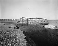 ETD Bridge over Green River |
February 22, 1985 (#85000439) |
County Road CN4-8SS 41°58′49″N 110°02′43″W |
Fontenelle | Bridge has been demolished. |
| 10 | ETR Big Island Bridge | 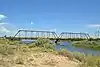 ETR Big Island Bridge |
February 22, 1985 (#85000440) |
County Road CN4-4 41°45′52″N 109°44′05″W |
Green River | |
| 11 | Expedition Island | 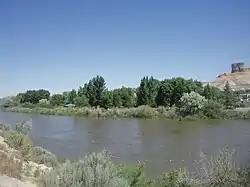 Expedition Island |
November 24, 1968 (#68000056) |
South of the Union Pacific railroad bridge, near the eastern bank of the Green River 41°31′28″N 109°28′19″W |
Green River | |
| 12 | The Finley Site | November 17, 2010 (#10000929) |
4 miles southeast of Eden Coordinates missing |
Eden | ||
| 13 | First National Bank Building | 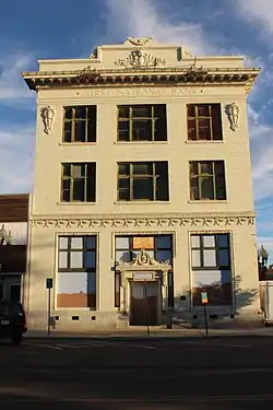 First National Bank Building |
March 13, 1980 (#80004054) |
502 S. Main St. 41°35′11″N 109°13′11″W |
Rock Springs | |
| 14 | Granger Station |  Granger Station |
February 26, 1970 (#70000678) |
In Granger 41°35′25″N 109°58′08″W |
Granger | |
| 15 | Gras House | 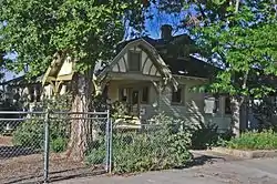 Gras House |
March 13, 1986 (#86000355) |
616 W. Elias 41°35′24″N 109°13′10″W |
Rock Springs | |
| 16 | Green River Downtown Historic District |  Green River Downtown Historic District |
January 8, 2009 (#08001306) |
72-142 Flaming Gorge Way, 58-94 N. 1st St., 125-200 E. Railroad Ave., 62-94 N. 1st E. St., and the pedestrian overpass 41°31′42″N 109°27′59″W |
Green River | |
| 17 | Laclede Station Ruin | 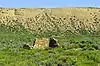 Laclede Station Ruin |
December 6, 1978 (#78002833) |
Off BLM Road 4409 along Bitter Creek, southeast of the community of Bitter Creek[5] 41°25′21″N 108°24′45″W |
Rock Springs | |
| 18 | Natural Corrals Archeological Site (48SW336) | August 17, 1987 (#87000873) |
Address restricted |
Superior | ||
| 19 | Our Lady of Sorrows Catholic Church | 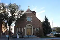 Our Lady of Sorrows Catholic Church |
November 6, 1997 (#97001326) |
A at Broadway 41°34′58″N 109°13′18″W |
Rock Springs | |
| 20 | Outlaw Inn | Outlaw Inn |
November 26, 2018 (#100003142) |
1630 Elk St. 41°36′45″N 109°13′50″W |
Rock Springs | A Best Western in 2018. |
| 21 | Parting of the Ways | 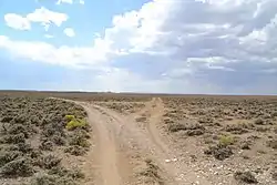 Parting of the Ways |
January 11, 1976 (#76001962) |
15 miles northeast of Farson 42°15′27″N 109°13′42″W |
Farson | |
| 22 | Point of Rocks Stage Station | 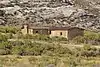 Point of Rocks Stage Station |
April 3, 1970 (#70000679) |
Off Interstate 80 41°40′30″N 108°47′30″W |
Rock Springs | |
| 23 | Red Rock | November 21, 1978 (#78002832) |
Southwest of Rawlins 41°25′46″N 108°00′05″W |
Rawlins | ||
| 24 | Reliance School and Gymnasium | .jpg.webp) Reliance School and Gymnasium |
May 13, 1988 (#87002303) |
1321 Main St. 41°39′38″N 109°11′31″W |
Reliance | |
| 25 | Reliance Tipple | _from_South_Street.jpg.webp) Reliance Tipple |
May 23, 1991 (#91000619) |
East of U.S. Route 187 41°40′05″N 109°11′46″W |
Reliance | |
| 26 | Rock Springs Elks' Lodge No. 624 | 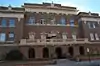 Rock Springs Elks' Lodge No. 624 |
December 10, 1993 (#93001383) |
307 C St. 41°35′03″N 109°13′07″W |
Rock Springs | |
| 27 | Saints Cyril and Methodius Catholic Church and Rectory | 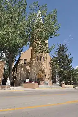 Saints Cyril and Methodius Catholic Church and Rectory |
December 22, 2015 (#15000929) |
633 Bridger Ave. 41°35′29″N 109°13′12″W |
Rock Springs | |
| 28 | Slovenski Dom | 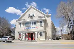 Slovenski Dom |
December 30, 1997 (#97001601) |
513 Bridger Ave. 41°35′29″N 109°13′15″W |
Rock Springs | |
| 29 | South Superior Union Hall | 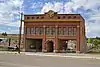 South Superior Union Hall |
November 25, 1983 (#83004305) |
Main and Bridge Sts. 41°45′45″N 108°58′03″W |
Superior | |
| 30 | Elinore Pruitt Stewart Homestead | April 25, 1985 (#85000871) |
Off Wyoming Highway 414 41°00′44″N 109°59′35″W |
McKinnon | ||
| 31 | Sweetwater Brewery | 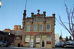 Sweetwater Brewery |
November 1, 1982 (#82001838) |
48 W. Railroad Ave. 41°31′44″N 109°28′05″W |
Green River | |
| 32 | Taliaferro House | 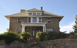 Taliaferro House |
July 23, 1998 (#98000909) |
106 Cedar St. 41°34′53″N 109°13′07″W |
Rock Springs | |
| 33 | Tolar Petroglyph Site | 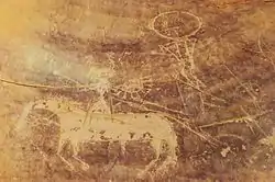 Tolar Petroglyph Site |
September 30, 2014 (#14000822) |
Address Restricted |
Point of Rocks | |
| 34 | US Post Office-Green River | 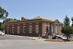 US Post Office-Green River |
December 11, 1997 (#97001535) |
3 W. Flaming Gorge Way 41°31′45″N 109°28′01″W |
Green River | No longer used as a post office. |
| 35 | Wardell Court Historic Residential District |  Wardell Court Historic Residential District |
January 30, 1997 (#96001630) |
Wardell Court at its junction with D St. 41°34′56″N 109°12′50″W |
Rock Springs |
See also
| Wikimedia Commons has media related to National Register of Historic Places in Sweetwater County, Wyoming. |
References
- The latitude and longitude information provided in this table was derived originally from the National Register Information System, which has been found to be fairly accurate for about 99% of listings. Some locations in this table may have been corrected to current GPS standards.
- "National Register of Historic Places: Weekly List Actions". National Park Service, United States Department of the Interior. Retrieved on January 29, 2021.
- Numbers represent an alphabetical ordering by significant words. Various colorings, defined here, differentiate National Historic Landmarks and historic districts from other NRHP buildings, structures, sites or objects.
- The eight-digit number below each date is the number assigned to each location in the National Register Information System database, which can be viewed by clicking the number.
- Location derived from its GNIS feature record; the NRIS lists the site as "Address Restricted"
| Topics | |
|---|---|
| Lists by state |
|
| Lists by insular areas | |
| Lists by associated state | |
| Other areas | |
| Related | |
| |
Municipalities and communities of Sweetwater County, Wyoming, United States | ||
|---|---|---|
| Cities | | |
| Towns | ||
| CDPs | ||
| Unincorporated communities | ||
| Ghost towns | ||
| Footnotes | ‡This populated place also has portions in an adjacent state | |
| ||
This article is issued from Wikipedia. The text is licensed under Creative Commons - Attribution - Sharealike. Additional terms may apply for the media files.