Gratiot County, Michigan
Gratiot County (/ˈɡræʃɪt/ GRASH-it) is a county in the U.S. state of Michigan. As of the 2010 census, the population was 42,476.[2] The county seat is Ithaca,[3] although its most populous city is Alma.
Gratiot County | |
|---|---|
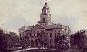 Gratiot County Courthouse | |
 Seal | |
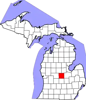 Location within the U.S. state of Michigan | |
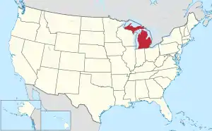 Michigan's location within the U.S. | |
| Coordinates: 43°17′N 84°36′W | |
| Country | |
| State | |
| Founded | 1855[1] |
| Named for | Charles Gratiot |
| Seat | Ithaca |
| Largest city | Alma |
| Area | |
| • Total | 572 sq mi (1,480 km2) |
| • Land | 568 sq mi (1,470 km2) |
| • Water | 3.1 sq mi (8 km2) 0.6%% |
| Population | |
| • Estimate (2019) | 40,711 |
| • Density | 75/sq mi (29/km2) |
| Time zone | UTC−5 (Eastern) |
| • Summer (DST) | UTC−4 (EDT) |
| Congressional district | 4th |
| Website | https://www.gratiotmi.com/ |
Gratiot County comprises the Alma, MI Micropolitan Statistical Area, which is also part of the Mount Pleasant-Alma, MI Combined Statistical Area.
The Gratiot County Courthouse was designed in the classical revival style by Claire Allen, a prominent southern Michigan architect. It is one of seven sites in the county listed on the National Register of Historic Places (No. 76002291 added 1976).[4]
In June 2012, the 212.8 MW Gratiot County Wind Project opened, the largest wind power installation in the state.[5]
History
The county is named for Captain Charles Gratiot, who supervised the building of Port Huron's Fort Gratiot. It was described by the Territorial Legislature in 1831. By 1855, the Territory had been admitted to the Union as a state; the State Legislature authorized the organization of Gratiot County that year – the death year of the county's namesake.
Gratiot County was a New England settlement. The original founders of Ithaca and of Alma were settlers from New England, "Yankees", descended from the English Puritans who settled the northeastern coast of the new continent in the 1600s. The Gratiot County settlers were farmers who headed west into what was then the wilds of the Northwest Territory during the early 1800s. Most of them arrived as a result of the completion of the Erie Canal as well as the close of the Black Hawk War. They arrived to virgin forest and wild prairie, but laid out farms, constructed roads, erected government buildings and established post routes. They maintained their customs, such as passion for education, and abhorrence of the existing slave trade. They were members of the Congregationalist Church or the Episcopal Church.[6][7][8]
In the 1890s, German immigrants began settling in Gratiot County.[1][9] See List of Michigan county name etymologies. Emil Lockwood, a noted Michigan legislator, represented Gratiot County in the Michigan Senate from 1963 to 1970, much of the time as Senate Majority Leader.
There are six Michigan historical markers in Gratiot County:
- Alma College
- Gratiot County
- Jackson Weller House
- Lumberjack Park
- Michigan Masonic Home
- Saginaw and Gratiot County State Road / Saginaw Valley & St. Louis Railroad[10]
Geography
According to the U.S. Census Bureau, the county has a total area of 572 square miles (1,480 km2), of which 568 square miles (1,470 km2) is land and 3.1 square miles (8.0 km2) (0.6%) is water.[11] It is considered to be part of Central Michigan.
Adjacent counties
- Midland County – northeast
- Isabella County – northwest
- Saginaw County – east
- Montcalm County – west
- Shiawassee County – southeast
- Clinton County – south
- Ionia County – southwest
Major highways
 US 127 – runs north to I-75 and south to Lansing.
 Bus. US 127 – business loop through downtown Alma.
- Bus. US 127 – business loop through downtown Ithaca.
- Bus. US 127 – business loop through downtown St. Louis.
 M-46 – cross-peninsular highway that runs east to Saginaw and Port Sanilac; runs west to Muskegon.
 M-57 – runs east to Flint; runs west to US 131 near Grand Rapids.
Demographics
| Historical population | |||
|---|---|---|---|
| Census | Pop. | %± | |
| 1860 | 4,042 | — | |
| 1870 | 11,810 | 192.2% | |
| 1880 | 21,936 | 85.7% | |
| 1890 | 28,668 | 30.7% | |
| 1900 | 29,889 | 4.3% | |
| 1910 | 28,820 | −3.6% | |
| 1920 | 33,914 | 17.7% | |
| 1930 | 30,252 | −10.8% | |
| 1940 | 32,205 | 6.5% | |
| 1950 | 33,429 | 3.8% | |
| 1960 | 37,012 | 10.7% | |
| 1970 | 39,246 | 6.0% | |
| 1980 | 40,448 | 3.1% | |
| 1990 | 38,982 | −3.6% | |
| 2000 | 42,285 | 8.5% | |
| 2010 | 42,476 | 0.5% | |
| 2019 (est.) | 40,711 | [12] | −4.2% |
| US Decennial Census[13] 1790-1960[14] 1900-1990[15] 1990-2000[16] 2010-2018[2] | |||
As of the 2000 United States Census,[17] there were 42,285 people, 14,501 households, and 10,397 families residing in the county. The population density was 74 people per square mile (29/km2). There were 15,516 housing units at an average density of 27 per square mile (11/km2). The racial makeup of the county was 92.01% White, 3.72% Black or African American, 0.55% Native American, 0.34% Asian, 0.02% Pacific Islander, 1.76% from other races, and 1.60% from two or more races. 4.43% of the population were Hispanic or Latino of any race. 29.8% were of English ancestry, 24.4% were of German ancestry and 6.9% Irish ancestry, 96.1% spoke English and 2.7% Spanish as their first language.
There were 14,501 households, out of which 34.00% had children under the age of 18 living with them, 57.60% were married couples living together, 10.20% had a female householder with no husband present, and 28.30% were non-families. 23.70% of all households were made up of individuals, and 10.70% had someone living alone who was 65 years of age or older. The average household size was 2.57 and the average family size was 3.02.
The county population included 23.80% under the age of 18, 11.60% from 18 to 24, 29.50% from 25 to 44, 21.60% from 45 to 64, and 13.50% who were 65 years of age or older. The median age was 36 years. For every 100 females there were 108.30 males. For every 100 females age 18 and over, there were 109.10 males.
The median income for a household in the county was $37,262, and the median income for a family was $43,954. Males had a median income of $32,442 versus $22,333 for females. The per capita income for the county was $17,118. About 7.30% of families and 10.30% of the population were below the poverty line, including 11.70% of those under age 18 and 9.20% of those age 65 or over.
Religion
The Roman Catholic Diocese of Saginaw is the controlling regional body for the Catholic Church.[18]
Government
Gratiot County has been reliably Republican from the beginning. Since 1884, the Republican Party nominee has carried the county vote in 76% of the elections (26 of 34 elections).
| Year | Republican | Democratic | Third Parties |
|---|---|---|---|
| 2020 | 63.2% 12,102 | 35.0% 6,693 | 1.8% 353 |
| 2016 | 60.0% 9,880 | 34.4% 5,666 | 5.6% 919 |
| 2012 | 51.4% 8,241 | 47.5% 7,610 | 1.2% 184 |
| 2008 | 46.9% 8,322 | 51.3% 9,105 | 1.8% 311 |
| 2004 | 56.6% 9,834 | 42.5% 7,377 | 1.0% 168 |
| 2000 | 54.8% 8,312 | 43.1% 6,538 | 2.2% 329 |
| 1996 | 41.8% 6,214 | 45.7% 6,793 | 12.6% 1,868 |
| 1992 | 39.6% 6,280 | 35.8% 5,678 | 24.7% 3,921 |
| 1988 | 59.4% 8,447 | 40.2% 5,719 | 0.5% 64 |
| 1984 | 72.1% 10,456 | 27.6% 4,000 | 0.3% 50 |
| 1980 | 59.3% 9,294 | 31.4% 4,916 | 9.3% 1,462 |
| 1976 | 63.0% 9,526 | 35.9% 5,429 | 1.1% 163 |
| 1972 | 68.4% 9,904 | 30.2% 4,370 | 1.4% 204 |
| 1968 | 62.7% 8,404 | 30.1% 4,040 | 7.2% 964 |
| 1964 | 42.0% 5,369 | 57.8% 7,383 | 0.2% 26 |
| 1960 | 71.8% 9,854 | 28.1% 3,859 | 0.2% 21 |
| 1956 | 75.7% 10,319 | 24.0% 3,267 | 0.3% 44 |
| 1952 | 77.1% 10,034 | 22.2% 2,887 | 0.8% 100 |
| 1948 | 70.2% 7,035 | 26.5% 2,659 | 3.3% 333 |
| 1944 | 71.0% 7,987 | 28.1% 3,160 | 0.9% 97 |
| 1940 | 69.0% 8,661 | 30.5% 3,825 | 0.5% 65 |
| 1936 | 47.1% 5,322 | 48.3% 5,457 | 4.6% 519 |
| 1932 | 44.4% 5,123 | 53.1% 6,124 | 2.5% 291 |
| 1928 | 82.1% 8,823 | 17.3% 1,854 | 0.6% 64 |
| 1924 | 76.1% 6,720 | 20.8% 1,839 | 3.1% 273 |
| 1920 | 77.4% 6,578 | 21.7% 1,846 | 0.9% 74 |
| 1916 | 52.2% 3,434 | 45.0% 2,960 | 2.9% 190 |
| 1912 | 30.6% 1,809 | 31.1% 1,835 | 38.3% 2,261 |
| 1908 | 61.7% 4,158 | 35.2% 2,372 | 3.2% 214 |
| 1904 | 67.6% 4,530 | 27.8% 1,863 | 4.6% 309 |
| 1900 | 55.5% 4,263 | 41.7% 3,202 | 2.8% 218 |
| 1896 | 45.0% 3,380 | 52.8% 3,971 | 2.2% 165 |
| 1892 | 48.8% 3,037 | 26.7% 1,661 | 24.5% 1,522 |
| 1888 | 52.4% 3,667 | 40.7% 2,854 | 6.9% 484 |
| 1884 | 47.0% 2,676 | 48.0% 2,736 | 5.0% 283 |
The county government operates the jail, maintains rural roads, operates the major local courts, records deeds, mortgages, and vital records, administers public health regulations, and participates with the state in the provision of other social services. The county board of commissioners controls the budget, and has limited authority to make laws or ordinances. In Michigan, most local government functions — police and fire, building and zoning, tax assessment, street maintenance, etc. — are the responsibility of individual cities and townships.
Elected officials
- Prosecuting Attorney: Keith J. Kushion
- Sheriff: Mike Morris
- County Clerk: Angie Thompson
- County Treasurer: Michelle Thomas
- Register of Deeds: Mary Merchant
- Drain Commissioner: Bernard J. Barnes
See also
References
- "Bibliography on Gratiot County". Clarke Historical Library, Central Michigan University. Retrieved January 19, 2013.
- "State & County QuickFacts". US Census Bureau. Archived from the original on July 5, 2011. Retrieved August 27, 2013.
- "Find a County". National Association of Counties. Archived from the original on May 31, 2011. Retrieved June 7, 2011.
- "National Register of Historical Places - Gratiot County MI".
- Michigan's Largest Wind Farm Enters Commercial Operation, North American Winpower, June 6, 2012
- Portrait and Biographical Album - Gratiot County MI (1884)
- Tucker, Willard Davis (1913). Gratiot County MI.
- An Index of Pioneers from Massachusetts to the West Especially the State of ... 1975. ISBN 9780806306605.
- Netherlanders in America: a study of emigration and settlement in the nineteenth and twentieth centuries in the United States of America, Volumes 1-2
- "Michigan Historical Markers". michmarkers.com. Archived from the original on April 12, 2018. Retrieved January 6, 2009.
- "2010 Census Gazetteer Files". US Census Bureau. August 22, 2012. Archived from the original on November 13, 2013. Retrieved September 21, 2014.
- "Population and Housing Unit Estimates". Retrieved January 15, 2021.
- "US Decennial Census". US Census Bureau. Retrieved September 21, 2014.
- "Historical Census Browser". University of Virginia Library. Retrieved September 21, 2014.
- "Population of Counties by Decennial Census: 1900 to 1990". US Census Bureau. Retrieved September 21, 2014.
- "Census 2000 PHC-T-4. Ranking Tables for Counties: 1990 and 2000" (PDF). US Census Bureau. Retrieved September 21, 2014.
- "U.S. Census website". US Census Bureau. Retrieved January 31, 2008.
- "Diocese of Saginaw".
- Leip, David. "Dave Leip's Atlas of US Presidential Elections". uselectionatlas.org. Retrieved April 8, 2018.
External links
- Gratiot County Government
- Gratiot County Area Chamber of Commerce
- Greater Gratiot Development
- Gratiot County Community Connection
- Gratiot County Community Foundation
- "Bibliography on Gratiot County". Clarke Historical Library, Central Michigan University.
Places adjacent to Gratiot County, Michigan | ||||||||||
|---|---|---|---|---|---|---|---|---|---|---|
| ||||||||||
Municipalities and communities of Gratiot County, Michigan, United States | ||
|---|---|---|
| Cities | Map of Michigan highlighting Gratiot County.svg | |
| Villages | ||
| Townships | ||
| Unincorporated communities | ||
| Ghost towns | ||
| Footnotes | ‡This populated place also has portions in an adjacent county or counties | |
| ||
Central/Mid-Michigan including the Tri-Cities and Thumb | |||||||
|---|---|---|---|---|---|---|---|
| Central cities | |||||||
| Counties |
| ||||||
| Geography | |||||||
| Transportation | |||||||
| Economy |
| ||||||
| Authority control |
|---|