La Garita Wilderness
The La Garita Wilderness is a U.S. Wilderness Area located in the La Garita Mountains of southern Colorado.[2][3] The 129,626-acre (524.58 km2) wilderness established in 1964 in Gunnison and Rio Grande National Forests includes segments of the Colorado Trail and the Continental Divide Trail. At 14,014 feet (4,271 m), San Luis Peak is the highest point in the wilderness area.
| La Garita Wilderness | |
|---|---|
IUCN category Ib (wilderness area) | |
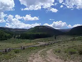 View of the La Garita Wilderness area from the parking lot at the terminus of Forest Road 787 | |
 | |
| Location | Hinsdale / Saguache / Mineral counties, Colorado, United States |
| Nearest city | Monte Vista, CO |
| Coordinates | 38°00′N 106°53′W[1] |
| Area | 129,626 acres (524.58 km2) |
| Established | 1964 |
| Governing body | U.S. Forest Service |
One entrance to the wilderness area is via Forest Road 787 from Saguache Park and Cochetopa Park off State Highway 114 west of Saguache, Colorado. There is a parking lot for visitors to the wilderness area at the south end of FS 787. Cochetopa Park may also be entered from the east over Cochetopa Pass via Saguache County Road NN14.
References
- "La Garita Wilderness". Geographic Names Information System. United States Geological Survey. Retrieved August 7, 2012.
- "La Garita Wilderness". U.S. Forest Service. Retrieved August 7, 2012.
- "La Garita Wilderness". Wilderness.net. Archived from the original on November 7, 2012. Retrieved August 7, 2012.

This article is issued from Wikipedia. The text is licensed under Creative Commons - Attribution - Sharealike. Additional terms may apply for the media files.