National Register of Historic Places listings in Converse County, Wyoming
This is a list of the National Register of Historic Places listings in Converse County, Wyoming.
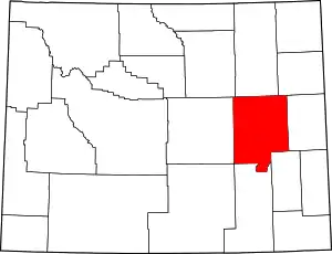
Location of Converse County in Wyoming
This is intended to be a complete list of the properties and districts on the National Register of Historic Places in Converse County, Wyoming, United States. The locations of National Register properties and districts for which the latitude and longitude coordinates are included below, may be seen in a map.[1]
There are 23 properties and districts listed on the National Register in the county.
- This National Park Service list is complete through NPS recent listings posted February 5, 2021.[2]
| Albany - Big Horn - Campbell - Carbon - Converse - Crook - Fremont - Goshen - Hot Springs - Johnson - Laramie - Lincoln - Natrona - Niobrara - Park - Platte - Sheridan - Sublette - Sweetwater - Teton - Uinta - Washakie - Weston |
Current listings
| [3] | Name on the Register | Image | Date listed[4] | Location | City or town | Description |
|---|---|---|---|---|---|---|
| 1 | Antelope Creek Crossing (48CO171 and 48CO165) | July 23, 1989 (#89000816) |
Confluence of Antelope Creek and Spring Draw, east of Ross[5] 43°25′45″N 105°48′28″W |
Ross | ||
| 2 | Braehead Ranch | September 7, 1995 (#95001074) |
69 Moss Agate Road 42°39′59″N 105°39′34″W |
Douglas | ||
| 3 | Christ Episcopal Church and Rectory |  Christ Episcopal Church and Rectory |
November 17, 1980 (#80004046) |
4th and Center Streets 42°45′35″N 105°22′54″W |
Douglas | |
| 4 | College Inn Bar | 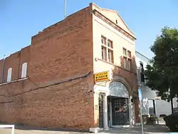 College Inn Bar |
July 10, 1979 (#79002608) |
103 North Second Street 42°45′36″N 105°23′00″W |
Douglas | |
| 5 | Commerce Block |  Commerce Block |
January 21, 2005 (#04001548) |
4th and Birch Streets 42°51′40″N 105°52′17″W |
Glenrock | |
| 6 | Dorr Ranch | December 22, 2014 (#14001080) |
Approximately 5 miles N.E. of Woody Creek & Steinle Roads 43°23′15″N 105°10′56″W |
Bill vicinity | ||
| 7 | Douglas City Hall | 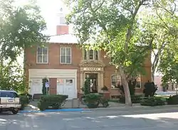 Douglas City Hall |
March 17, 1994 (#94000167) |
130 South Third Street 42°45′29″N 105°23′02″W |
Douglas | |
| 8 | Fort Fetterman | 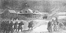 Fort Fetterman |
April 16, 1969 (#69000187) |
7 miles north of Interstate 25 on Orpha Road 42°50′36″N 105°29′07″W |
Orpha | |
| 9 | Fremont, Elkhorn & Missouri Valley Railroad Passenger Depot | .jpg.webp) Fremont, Elkhorn & Missouri Valley Railroad Passenger Depot |
August 3, 1994 (#94000741) |
121 Brownfield Rd. 42°45′32″N 105°23′15″W |
Douglas | |
| 10 | Glenrock Buffalo Jump | April 16, 1969 (#69000186) |
Near the center of Section 11, Township 33 North, Range 76 West[6] 42°50′38″N 105°56′00″W |
Glenrock | ||
| 11 | Holdup Hollow Segment, Bozeman Trail (48CO165) | July 23, 1989 (#89000818) |
In Holdup Hollow, north of Glenrock[7] 43°05′39″N 105°42′50″W |
Glenrock | ||
| 12 | Hotel Higgins | 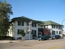 Hotel Higgins |
November 25, 1983 (#83004280) |
416 West Birch 42°51′40″N 105°52′23″W |
Glenrock | |
| 13 | Hotel LaBonte | 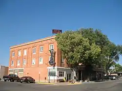 Hotel LaBonte |
October 10, 2008 (#08001003) |
206 Walnut Street 42°45′40″N 105°23′06″W |
Douglas | |
| 14 | Huxtable Ranch Headquarters District | April 7, 2011 (#10001172) |
1351 Boxelder Road 42°40′06″N 105°48′15″W |
Glenrock | Ranches, Farms, and Homesteads in Wyoming, 1860-1960 MPS | |
| 15 | Jenne Block | 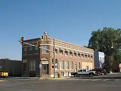 Jenne Block |
January 6, 1998 (#97001600) |
301 Center Street 42°45′33″N 105°22′59″W |
Douglas | |
| 16 | La Prele Work Center | April 11, 1994 (#94000272) |
Southwest of Douglas, Medicine Bow National Forest 42°27′29″N 105°50′02″W |
Douglas | ||
| 17 | Morton Mansion | 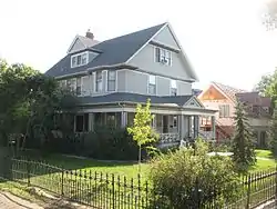 Morton Mansion |
January 11, 2001 (#00001644) |
425 Center Street 42°45′33″N 105°22′51″W |
Douglas | |
| 18 | North Douglas Historic District | November 25, 2002 (#00001470) |
Roughly bounded by 2nd St., Clay St., 6th St., and Center St. 42°45′45″N 105°22′54″W |
Douglas | ||
| 19 | Officer's Club, Douglas Prisoner of War Camp | 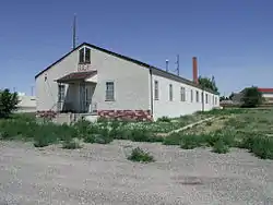 Officer's Club, Douglas Prisoner of War Camp |
September 8, 2001 (#01000965) |
115 South Riverbend Drive 42°45′31″N 105°24′22″W |
Douglas | |
| 20 | Ross Flat Segment, Bozeman Trail (48CO165) | July 23, 1989 (#89000811) |
Ends at Ross Flat, northwest of Ross[8] 43°29′26″N 105°49′49″W |
Ross | ||
| 21 | Sage Creek Station (48CO104) |  Sage Creek Station (48CO104) |
July 23, 1989 (#89000812) |
Address Restricted |
Glenrock | |
| 22 | Stinking Water Gulch Segment, Bozeman Trail (48CO165) | July 23, 1989 (#89000817) |
Along Stinking Water Gulch, southeast of Ross[9] 43°19′38″N 105°41′12″W |
Ross | ||
| 23 | US Post Office-Douglas Main | 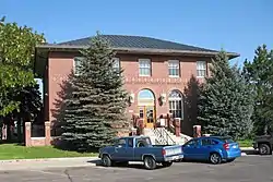 US Post Office-Douglas Main |
May 19, 1987 (#87000781) |
129 North Third Street 42°45′38″N 105°22′59″W |
Douglas |
See also
| Wikimedia Commons has media related to National Register of Historic Places in Converse County, Wyoming. |
References
- The latitude and longitude information provided in this table was derived originally from the National Register Information System, which has been found to be fairly accurate for about 99% of listings. Some locations in this table may have been corrected to current GPS standards.
- "National Register of Historic Places: Weekly List Actions". National Park Service, United States Department of the Interior. Retrieved on February 5, 2021.
- Numbers represent an alphabetical ordering by significant words. Various colorings, defined here, differentiate National Historic Landmarks and historic districts from other NRHP buildings, structures, sites or objects.
- The eight-digit number below each date is the number assigned to each location in the National Register Information System database, which can be viewed by clicking the number.
- Location derived from this Wyoming State Historic Preservation Office website; coordinates derived from the mouth of Spring Draw at Antelope Creek as given in its GNIS feature record. The NRIS lists the site as "Address Restricted".
- Albanese, John. "Appendix III: Geology of the Glenrock Site Area, Wyoming". Plains Anthropologist 15.50 (1970): 56-66: 56.
- Location derived from this Wyoming State Historic Preservation Office webpage; coordinates derived from the GNIS feature record for Holdup Hollow. The NRIS lists the site as "Address Restricted".
- Location derived from this Wyoming State Historic Preservation Office website and the GNIS feature record for Ross Flat; the NRIS lists the site as "Address Restricted"
- Location derived from the GNIS feature record for Stinking Water Gulch; the NRIS lists the site as "Address Restricted"
| Topics | |
|---|---|
| Lists by state |
|
| Lists by insular areas | |
| Lists by associated state | |
| Other areas | |
| Related | |
| |
Municipalities and communities of Converse County, Wyoming, United States | ||
|---|---|---|
| City | | |
| Towns | ||
| CDPs | ||
| Unincorporated communities | ||
| ||
This article is issued from Wikipedia. The text is licensed under Creative Commons - Attribution - Sharealike. Additional terms may apply for the media files.