National Register of Historic Places listings in Lincoln County, Wyoming
This is a list of the National Register of Historic Places listings in Lincoln County, Wyoming.
Location of Lincoln County in Wyoming
It is intended to be a complete list of the properties and districts on the National Register of Historic Places in Lincoln County, Wyoming, United States. The locations of National Register properties and districts for which the latitude and longitude coordinates are included below, may be seen in a map.[1]
There are 13 properties and districts listed on the National Register in the county, 1 of which is a National Historic Landmark. Another property was previously listed on the National Register but has been removed.
- This National Park Service list is complete through NPS recent listings posted January 29, 2021.[2]
| Albany - Big Horn - Campbell - Carbon - Converse - Crook - Fremont - Goshen - Hot Springs - Johnson - Laramie - Lincoln - Natrona - Niobrara - Park - Platte - Sheridan - Sublette - Sweetwater - Teton - Uinta - Washakie - Weston |
Current listings
| [3] | Name on the Register | Image | Date listed[4] | Location | City or town | Description |
|---|---|---|---|---|---|---|
| 1 | Emigrant Springs | January 11, 1976 (#76001956) |
Approximately 18 miles (29 km) west of Fontenelle[5] 41°58′39″N 110°24′23″W |
Kemmerer | ||
| 2 | Gateway | August 24, 2020 (#100005447) |
Address Restricted |
La Barge vicinity | ||
| 3 | Haddenham Cabin |  Haddenham Cabin |
December 23, 2003 (#03001339) |
Fossil Butte National Monument 41°49′49″N 110°43′52″W |
Kemmerer | |
| 4 | Fossil Oregon Short Line Depot | 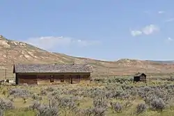 Fossil Oregon Short Line Depot |
December 11, 2013 (#13000919) |
Approx. .4 mi. WNW. of the Jct. of US 30 & Cty. Rd. 300 41°49′00″N 110°43′35″W |
Kemmerer | |
| 5 | Johnston Scout Rocks | November 7, 1976 (#76001957) |
Approximately 1 mile (1.6 km) south of Emigrant Springs[6] 41°57′55″N 110°24′32″W |
Kemmerer | ||
| 6 | La Barge Bluffs Petroglyphs | April 7, 2014 (#14000134) |
Address Restricted |
La Barge | ||
| 7 | Lincoln County Courthouse | 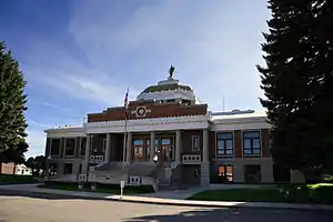 Lincoln County Courthouse |
November 8, 1984 (#84000385) |
Sage Ave. and Garnet St. 41°47′33″N 110°32′24″W |
Kemmerer | |
| 8 | Names Hill | 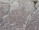 Names Hill |
April 16, 1969 (#69000193) |
On the Green River, 5 mi (8.0 km) south of LaBarge and west of U.S. Route 189 42°09′03″N 110°11′04″W |
La Barge | |
| 9 | J. C. Penney Historic District | 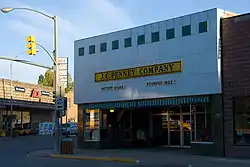 J. C. Penney Historic District |
June 2, 1978 (#78002830) |
J.C. Penney Ave. and S. Main St. 41°47′41″N 110°32′09″W |
Kemmerer | |
| 10 | J.C. Penney House |  J.C. Penney House |
June 18, 1976 (#76001958) |
Railroad Park 41°47′43″N 110°32′08″W |
Kemmerer | |
| 11 | Rock Church |  Rock Church |
December 13, 1985 (#85003222) |
2nd W. and 1st S. Sts. 42°47′30″N 111°00′04″W |
Auburn | |
| 12 | Salt River Hydroelectric Powerplant | December 2, 1993 (#93000889) |
End of County Road 12-104, 0.7 miles west of U.S. Route 89 43°06′14″N 111°02′20″W |
Etna | Extends into Bonneville County, Idaho | |
| 13 | US Post Office-Kemmerer Main | 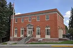 US Post Office-Kemmerer Main |
May 19, 1987 (#87000786) |
318 Sapphire St. 41°47′40″N 110°32′18″W |
Kemmerer |
Former listings
| [3] | Name on the Register | Image | Date listed | Date removed | Location | City or town | Summary |
|---|---|---|---|---|---|---|---|
| 1 | Kemmerer Hotel | December 2, 1985 (#85003064) | December 11, 2013 | Pine and Sapphire 41°47′39″N 110°32′18″W |
Kemmerer | Demolished in June 2004 |
See also
| Wikimedia Commons has media related to National Register of Historic Places in Lincoln County, Wyoming. |
References
- The latitude and longitude information provided in this table was derived originally from the National Register Information System, which has been found to be fairly accurate for about 99% of listings. Some locations in this table may have been corrected to current GPS standards.
- "National Register of Historic Places: Weekly List Actions". National Park Service, United States Department of the Interior. Retrieved on January 29, 2021.
- Numbers represent an alphabetical ordering by significant words. Various colorings, defined here, differentiate National Historic Landmarks and historic districts from other NRHP buildings, structures, sites or objects.
- The eight-digit number below each date is the number assigned to each location in the National Register Information System database, which can be viewed by clicking the number.
- Location derived from this Wyoming State Historic Preservation Office webpage, and coordinates derived from its GNIS feature record; the NRIS lists the site as "Address Restricted"
- Location derived from this Wyoming State Historic Preservation Office webpage; the NRIS lists the site as "Address Restricted"
| Topics | |
|---|---|
| Lists by state |
|
| Lists by insular areas | |
| Lists by associated state | |
| Other areas | |
| Related | |
| |
Municipalities and communities of Lincoln County, Wyoming, United States | ||
|---|---|---|
| City | | |
| Towns | ||
| CDPs | ||
| Unincorporated communities | ||
| Footnotes | ‡This populated place also extends into Idaho | |
| ||
This article is issued from Wikipedia. The text is licensed under Creative Commons - Attribution - Sharealike. Additional terms may apply for the media files.