National Register of Historic Places listings in Uinta County, Wyoming
This is a list of the National Register of Historic Places listings in Uinta County, Wyoming.
Location of Uinta County in Wyoming
This is intended to be a complete list of the properties and districts on the National Register of Historic Places in Uinta County, Wyoming, United States. The locations of National Register properties and districts for which the latitude and longitude coordinates are included below, may be seen in a map.[1]
There are 14 properties and districts listed on the National Register in the county.
- This National Park Service list is complete through NPS recent listings posted January 29, 2021.[2]
| Albany - Big Horn - Campbell - Carbon - Converse - Crook - Fremont - Goshen - Hot Springs - Johnson - Laramie - Lincoln - Natrona - Niobrara - Park - Platte - Sheridan - Sublette - Sweetwater - Teton - Uinta - Washakie - Weston |
Current listings
| [3] | Name on the Register | Image | Date listed[4] | Location | City or town | Description |
|---|---|---|---|---|---|---|
| 1 | Black and Orange Cabins | April 23, 2020 (#100005191) |
37000 Business Rte. I 80 (Fort Bridger State Historic Site) 41°19′07″N 110°23′20″W |
Fort Bridger | ||
| 2 | Bridger Antelope Trap |  Bridger Antelope Trap |
January 21, 1971 (#71000893) |
Address Restricted |
Evanston | |
| 3 | Downtown Evanston Historic District |  Downtown Evanston Historic District |
November 25, 1983 (#83004307) |
Roughly bounded by Center, 9th, 11th, and Front Sts. 41°16′04″N 110°57′53″W |
Evanston | |
| 4 | ERT Bridge over Black's Fork | 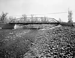 ERT Bridge over Black's Fork |
February 22, 1985 (#85000441) |
County Road CN19-217 41°18′06″N 110°23′29″W |
Fort Bridger | Replaced in 1988 |
| 5 | Fort Bridger | 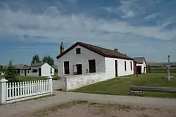 Fort Bridger |
April 16, 1969 (#69000197) |
On Black's Fork of the Green River, near Fort Bridger 41°19′00″N 110°23′30″W |
Fort Bridger | |
| 6 | Piedmont Charcoal Kilns | 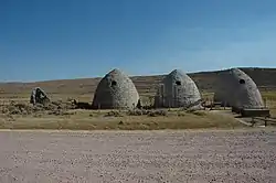 Piedmont Charcoal Kilns |
June 3, 1971 (#71000894) |
14 mi (23 km) northeast of Hilliard 41°13′11″N 110°37′07″W |
Hilliard | |
| 7 | A. V. Quinn House | 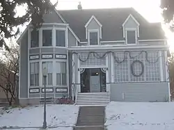 A. V. Quinn House |
September 13, 1984 (#84003712) |
1049 Center St. 41°16′03″N 110°58′01″W |
Evanston | |
| 8 | St. Paul's Episcopal Church | 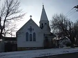 St. Paul's Episcopal Church |
November 17, 1980 (#80004057) |
10th and Sage Sts. 41°15′57″N 110°58′01″W |
Evanston | |
| 9 | Triangulation Point Draw Site District (48UT114; 48UT377; 48UT392; 48UT440) | Triangulation Point Draw Site District (48UT114; 48UT377; 48UT392; 48UT440) |
September 16, 1986 (#86002320) |
Address Restricted |
Verne | |
| 10 | Uinta County Courthouse | 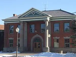 Uinta County Courthouse |
July 14, 1977 (#77001385) |
Courthouse Sq. 41°15′59″N 110°57′50″W |
Evanston | |
| 11 | Union Pacific Railroad Complex | 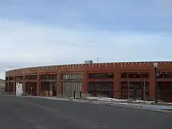 Union Pacific Railroad Complex |
February 26, 1985 (#85000685) |
Main and 15th Sts. 41°16′16″N 110°58′09″W |
Evanston | |
| 12 | US Post Office-Evanston Main | 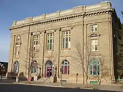 US Post Office-Evanston Main |
May 19, 1987 (#87000790) |
221 10th St. 41°16′02″N 110°57′56″W |
Evanston | |
| 13 | Wyoming State Insane Asylum | 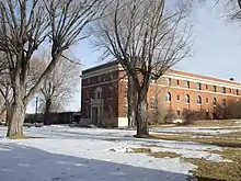 Wyoming State Insane Asylum |
February 27, 2003 (#03000084) |
831 Wyoming Highway 150 S. 41°15′48″N 110°56′58″W |
Evanston | |
| 14 | Brigham Young Oil Well | April 25, 1985 (#85000872) |
Northeastern quarter of the northeastern quarter of Section 4, Township 13, Range 119[5] 41°08′15″N 110°50′10″W |
Evanston |
See also
| Wikimedia Commons has media related to National Register of Historic Places in Uinta County, Wyoming. |
References
- The latitude and longitude information provided in this table was derived originally from the National Register Information System, which has been found to be fairly accurate for about 99% of listings. Some locations in this table may have been corrected to current GPS standards.
- "National Register of Historic Places: Weekly List Actions". National Park Service, United States Department of the Interior. Retrieved on January 29, 2021.
- Numbers represent an alphabetical ordering by significant words. Various colorings, defined here, differentiate National Historic Landmarks and historic districts from other NRHP buildings, structures, sites or objects.
- The eight-digit number below each date is the number assigned to each location in the National Register Information System database, which can be viewed by clicking the number.
- Emmons, Samuel Franklin, and Edwin Clarence Eckel. Contributions to Economic Geology, 1905. United States Geological Survey Bulletin 285. Washington: GPO, 1906, 345.
| Topics | |
|---|---|
| Lists by state |
|
| Lists by insular areas | |
| Lists by associated state | |
| Other areas | |
| Related | |
| |
Municipalities and communities of Uinta County, Wyoming, United States | ||
|---|---|---|
| City | | |
| Towns | ||
| CDPs | ||
| Ghost towns | ||
| ||
This article is issued from Wikipedia. The text is licensed under Creative Commons - Attribution - Sharealike. Additional terms may apply for the media files.