National Register of Historic Places listings in Platte County, Wyoming
This is a list of the National Register of Historic Places listings in Platte County, Wyoming.
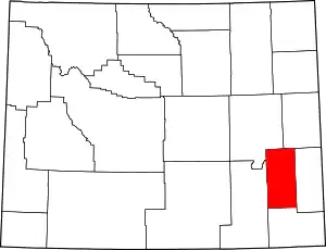
Location of Platte County in Wyoming
It is intended to be a complete list of the properties and districts on the National Register of Historic Places in Platte County, Wyoming, United States. The locations of National Register properties and districts for which the latitude and longitude coordinates are included below, may be seen in a map.[1]
There are 11 properties and districts listed on the National Register in the county, 3 of which are National Historic Landmarks. One previous listing has been removed from the Register.
- This National Park Service list is complete through NPS recent listings posted January 29, 2021.[2]
| Albany - Big Horn - Campbell - Carbon - Converse - Crook - Fremont - Goshen - Hot Springs - Johnson - Laramie - Lincoln - Natrona - Niobrara - Park - Platte - Sheridan - Sublette - Sweetwater - Teton - Uinta - Washakie - Weston |
Current listings
| [3] | Name on the Register | Image | Date listed[4] | Location | City or town | Description |
|---|---|---|---|---|---|---|
| 1 | Diamond Ranch | September 28, 1984 (#84003696) |
Northwest of Chugwater 41°44′45″N 105°03′15″W |
Chugwater | ||
| 2 | EWZ Bridge over East Channel of Laramie River | 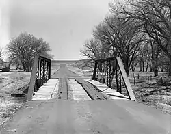 EWZ Bridge over East Channel of Laramie River |
February 22, 1985 (#85000431) |
County Road CN8-204 42°02′41″N 105°08′51″W |
Wheatland | Replaced |
| 3 | Duncan Grant Ranch Rural Historic Landscape |  Duncan Grant Ranch Rural Historic Landscape |
February 27, 2013 (#13000047) |
778 Sybille Creek Rd. 41°58′35″N 105°03′36″W |
Wheatland | |
| 4 | Robert Grant Ranch | September 7, 1995 (#95001073) |
433 Richeau Rd. 41°50′55″N 104°56′54″W |
Wheatland | Now in its fourth generation, the Grant Ranch provides pasture to grazing leaseholders. It was owned until his death in 2012 by the former Wyoming State Representative Robert Mills Grant. | |
| 5 | Guernsey Lake Park | .jpg.webp) Guernsey Lake Park |
August 26, 1980 (#80004051) |
1 mi (1.6 km) northwest of Guernsey 42°17′15″N 104°45′32″W |
Guernsey | Designated a National Historic Landmark District on September 25, 1997 |
| 6 | Oregon Trail Ruts | 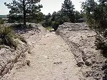 Oregon Trail Ruts |
October 15, 1966 (#66000761) |
Southern side of the North Platte River, .5 mi (0.80 km) south of Guernsey 42°15′15″N 104°44′47″W |
Guernsey | |
| 7 | Patten Creek Site |  Patten Creek Site |
September 11, 1989 (#89001204) |
Address Restricted |
Hartville | |
| 8 | Platte County Courthouse | 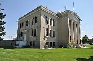 Platte County Courthouse |
October 15, 2008 (#08001004) |
900 9th St. 42°03′20″N 104°57′11″W |
Wheatland | |
| 9 | Register Cliff | 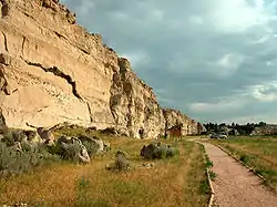 Register Cliff |
April 3, 1970 (#70000674) |
Southeast of Guernsey on the North Platte River 42°14′53″N 104°42′37″W |
Guernsey | |
| 10 | Sunrise Mine Historic District | 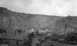 Sunrise Mine Historic District |
December 23, 2005 (#05000925) |
Wyoming Highway 318 42°19′55″N 104°42′11″W |
Hartville | |
| 11 | Swan Land and Cattle Company Headquarters | .jpg.webp) Swan Land and Cattle Company Headquarters |
October 15, 1966 (#66000760) |
Eastern side of Chugwater 41°44′54″N 104°49′05″W |
Chugwater |
Former listing
| [3] | Name on the Register | Image | Date listed | Date removed | Location | City or town | Summary |
|---|---|---|---|---|---|---|---|
| 1 | Wheatland Railroad Depot | February 16, 1996 (#96000077) | September 5, 2017 | 701 Gilchrist Ave. 42°03′15″N 104°57′03″W |
Wheatland | Destroyed [5][6] |
See also
| Wikimedia Commons has media related to National Register of Historic Places in Platte County, Wyoming. |
References
- The latitude and longitude information provided in this table was derived originally from the National Register Information System, which has been found to be fairly accurate for about 99% of listings. Some locations in this table may have been corrected to current GPS standards.
- "National Register of Historic Places: Weekly List Actions". National Park Service, United States Department of the Interior. Retrieved on January 29, 2021.
- Numbers represent an alphabetical ordering by significant words. Various colorings, defined here, differentiate National Historic Landmarks and historic districts from other NRHP buildings, structures, sites or objects.
- The eight-digit number below each date is the number assigned to each location in the National Register Information System database, which can be viewed by clicking the number.
| Topics | |
|---|---|
| Lists by state |
|
| Lists by insular areas | |
| Lists by associated state | |
| Other areas | |
| Related | |
| |
Municipalities and communities of Platte County, Wyoming, United States | ||
|---|---|---|
| Towns | | |
| CDPs | ||
| Unincorporated communities | ||
| Ghost town | ||
| ||
This article is issued from Wikipedia. The text is licensed under Creative Commons - Attribution - Sharealike. Additional terms may apply for the media files.