National Register of Historic Places listings in Sublette County, Wyoming
This is a list of the National Register of Historic Places listings in Sublette County, Wyoming. It is intended to be a complete list of the properties and districts on the National Register of Historic Places in Sublette County, Wyoming, United States. The locations of National Register properties and districts for which the latitude and longitude coordinates are included below, may be seen in a map.[1]
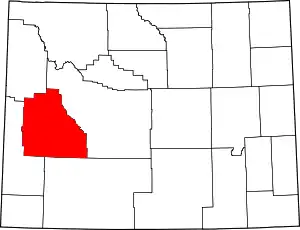
Location of Sublette County in Wyoming
There are 22 properties and districts listed on the National Register in the county, 1 of which is a National Historic Landmark.
- This National Park Service list is complete through NPS recent listings posted January 29, 2021.[2]
| Albany - Big Horn - Campbell - Carbon - Converse - Crook - Fremont - Goshen - Hot Springs - Johnson - Laramie - Lincoln - Natrona - Niobrara - Park - Platte - Sheridan - Sublette - Sweetwater - Teton - Uinta - Washakie - Weston |
Current listings
| [3] | Name on the Register | Image | Date listed[4] | Location | City or town | Description |
|---|---|---|---|---|---|---|
| 1 | Archeological Site No. 48SU354 | May 13, 1994 (#94000439) |
Address Restricted |
Big Piney | ||
| 2 | Church of St. Hubert the Hunter and Library | 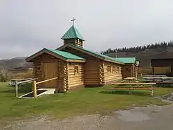 Church of St. Hubert the Hunter and Library |
January 24, 2002 (#01001525) |
U.S. Routes 189 and 191 43°12′05″N 110°24′22″W |
Bondurant | |
| 3 | Circle Ranch |  Circle Ranch |
May 14, 1987 (#87000778) |
4 miles southwest of Big Piney off Wyoming Highway 350 42°31′19″N 110°10′49″W |
Big Piney | |
| 4 | Cora Townsite |  Cora Townsite |
April 24, 2017 (#100000925) |
5 Noble Rd. 42°56′21″N 109°58′44″W |
Cora | |
| 5 | Craig Cabin | September 19, 2016 (#16000648) |
Approx. 4 miles (6.4 km) E. of Dell & Jack Creeks 43°14′26″N 110°16′13″W |
Bondurant | ||
| 6 | Daniel School | 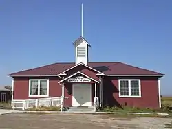 Daniel School |
September 5, 1990 (#90001387) |
U.S. Route 189 42°51′53″N 110°04′29″W |
Daniel | |
| 7 | DDZ Bridge over New Fork River |  DDZ Bridge over New Fork River |
February 22, 1985 (#85000437) |
County Road 136 42°45′02″N 109°43′33″W |
Boulder | Replaced in 1989 |
| 8 | ENP Bridge over Green River | 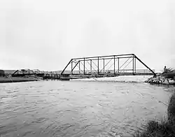 ENP Bridge over Green River |
February 22, 1985 (#85000438) |
County Road CN23-145 42°46′47″N 109°58′07″W |
Daniel | |
| 9 | Father DeSmet's Prairie Mass Site | 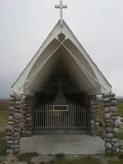 Father DeSmet's Prairie Mass Site |
April 28, 1970 (#70000676) |
Off U.S. Route 187 42°52′10″N 110°02′29″W |
Daniel | |
| 10 | Fort Bonneville | 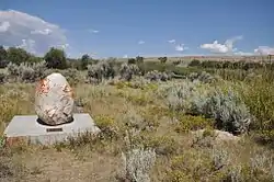 Fort Bonneville |
April 28, 1970 (#70000677) |
Off U.S. Route 189 42°53′40″N 110°08′03″W |
Pinedale | |
| 11 | Green River Drift Trail Traditional Cultural Property | November 22, 2013 (#12001224) |
Generally follows upper Green River 42°54′50″N 109°58′44″W |
Cora | ||
| 12 | Jensen Ranch | May 5, 1988 (#88000552) |
Martin Jensen County Rd. 42°38′22″N 109°31′28″W |
Boulder | ||
| 13 | Lander Road-New Fork River Crossing | January 17, 2017 (#100000525) |
1371 Paradise Rd., 23-136 (West Side of New Fork River) 42°36′42″N 109°51′23″W |
Boulder | ||
| 14 | Log Cabin Motel | 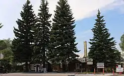 Log Cabin Motel |
March 25, 1993 (#93000230) |
49 E. Magnolia St. 42°52′04″N 109°51′34″W |
Pinedale | |
| 15 | New Fork | July 16, 1987 (#87000773) |
3 miles south of Boulder on U.S. Route 187 42°42′13″N 109°42′55″W |
Boulder | ||
| 16 | Redick Lodge | March 18, 1983 (#83003364) |
North of Pinedale 42°59′34″N 109°48′08″W |
Pinedale | ||
| 17 | Sommers Ranch Headquarters Historic District | June 18, 2009 (#09000454) |
734 County Road 23-110 42°46′45″N 109°57′46″W |
Pinedale | ||
| 18 | Steele Homestead | April 25, 1985 (#85000870) |
Wyoming Highway 191 42°45′17″N 109°37′14″W |
Boulder | ||
| 19 | Trappers Point Site | 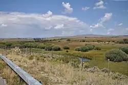 Trappers Point Site |
May 14, 2007 (#07000368) |
6 miles (9.7 km) west of Pinedale[5] 42°52′34″N 109°56′45″W |
Pinedale | |
| 20 | Union Pass |  Union Pass |
April 16, 1969 (#69000367) |
On the Continental Divide in Teton National Forest 43°28′54″N 109°52′24″W |
Unknown | |
| 21 | Upper Green River Rendezvous Site |  Upper Green River Rendezvous Site |
October 15, 1966 (#66000763) |
On the Green River above and below Daniel 42°52′25″N 110°02′14″W |
Daniel | |
| 22 | Wardell Buffalo Trap | August 12, 1971 (#71000892) |
Address Restricted |
Big Piney |
See also
| Wikimedia Commons has media related to National Register of Historic Places in Sublette County, Wyoming. |
References
- The latitude and longitude information provided in this table was derived originally from the National Register Information System, which has been found to be fairly accurate for about 99% of listings. Some locations in this table may have been corrected to current GPS standards.
- "National Register of Historic Places: Weekly List Actions". National Park Service, United States Department of the Interior. Retrieved on January 29, 2021.
- Numbers represent an alphabetical ordering by significant words. Various colorings, defined here, differentiate National Historic Landmarks and historic districts from other NRHP buildings, structures, sites or objects.
- The eight-digit number below each date is the number assigned to each location in the National Register Information System database, which can be viewed by clicking the number.
- Miller, Mark E., and Paul H. Sanders. "The Tappers Point Site (48SU1006): Early Archaic Adaptations and Pronghorn Procurement in the Upper Green River Basin, Wyoming". Plains Anthropologist 45.174 (2000): 39-52: 46.
| Topics | |
|---|---|
| Lists by state |
|
| Lists by insular areas | |
| Lists by associated state | |
| Other areas | |
| Related | |
| |
Municipalities and communities of Sublette County, Wyoming, United States | ||
|---|---|---|
| Towns | | |
| CDPs | ||
| Unincorporated communities | ||
| Ghost towns | ||
| ||
This article is issued from Wikipedia. The text is licensed under Creative Commons - Attribution - Sharealike. Additional terms may apply for the media files.