National Register of Historic Places listings in Sheridan County, Wyoming
This is a list of the National Register of Historic Places listings in Sheridan County, Wyoming. It is intended to be a complete list of the properties and districts on the National Register of Historic Places in Sheridan County, Wyoming, United States. The locations of National Register properties and districts for which the latitude and longitude coordinates are included below, may be seen in a map.[1]
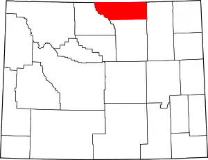
Location of Sheridan County in Wyoming
There are 27 properties and districts listed on the National Register in the county, 1 of which is a National Historic Landmark.
- This National Park Service list is complete through NPS recent listings posted January 29, 2021.[2]
| Albany - Big Horn - Campbell - Carbon - Converse - Crook - Fremont - Goshen - Hot Springs - Johnson - Laramie - Lincoln - Natrona - Niobrara - Park - Platte - Sheridan - Sublette - Sweetwater - Teton - Uinta - Washakie - Weston |
Current listings
| [3] | Name on the Register | Image | Date listed[4] | Location | City or town | Description |
|---|---|---|---|---|---|---|
| 1 | Big Goose Creek Buffalo Jump |  Big Goose Creek Buffalo Jump |
February 12, 1974 (#74002031) |
Address Restricted[5] |
Sheridan | |
| 2 | Big Red Ranch Complex | October 11, 1984 (#84000437) |
Off U.S. Routes 14/16 44°33′52″N 106°31′37″W |
Ucross | ||
| 3 | CKW Bridge over Powder River | 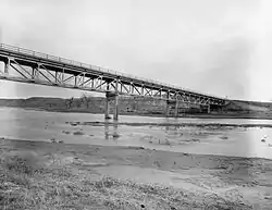 CKW Bridge over Powder River |
February 22, 1985 (#85000432) |
U.S. Routes 14/16 44°41′51″N 106°05′58″W |
Arvada | Replaced in 1990 |
| 4 | Clearmont Jail | Clearmont Jail |
May 14, 1984 (#84003698) |
Water St. 44°38′20″N 106°22′46″W |
Clearmont | |
| 5 | Connor Battlefield | 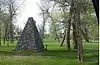 Connor Battlefield |
August 12, 1971 (#71000891) |
City park on the Tongue River 44°54′19″N 107°09′43″W |
Ranchester | |
| 6 | Dayton Community Hall | 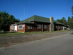 Dayton Community Hall |
November 25, 2005 (#05001338) |
410 Bridge St. 44°52′34″N 107°15′52″W |
Dayton | |
| 7 | Dayton Mercantile | 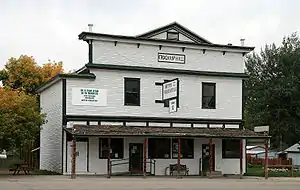 Dayton Mercantile |
May 12, 2016 (#16000264) |
408 Main St. 44°52′32″N 107°15′46″W |
Dayton | |
| 8 | EAU Arvada Bridge | 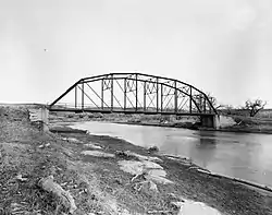 EAU Arvada Bridge |
February 22, 1985 (#85000433) |
County Road CN3-38 44°39′35″N 106°07′48″W |
Arvada | Replaced in 1990. |
| 9 | EBF Bridge over Powder River | 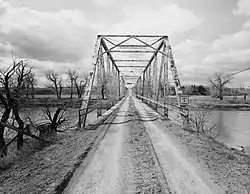 EBF Bridge over Powder River |
February 22, 1985 (#85000434) |
County Road CN3-269 44°52′49″N 106°03′41″W |
Leiter | Replaced in 1989 |
| 10 | ECR Kooi Bridge | 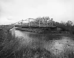 ECR Kooi Bridge |
February 22, 1985 (#85000436) |
County Road CN3-93 44°54′33″N 107°05′13″W |
Monarch | Replaced in 2003 |
| 11 | ECS Bridge over Big Goose Creek | 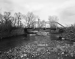 ECS Bridge over Big Goose Creek |
February 22, 1985 (#85000435) |
County Road CN3-93 44°44′35″N 107°07′45″W |
Sheridan | |
| 12 | Fort Mackenzie | June 18, 1981 (#81000612) |
North of Sheridan on Wyoming Highway 337 44°49′39″N 106°58′55″W |
Sheridan | ||
| 13 | Holy Name Catholic School | 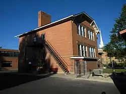 Holy Name Catholic School |
April 23, 2013 (#13000212) |
121 S. Connor St. 44°47′44″N 106°57′05″W |
Sheridan | |
| 14 | Johnson Street Historic District | April 9, 1984 (#84003701) |
Johnson, 1st, and 2nd Sts. 44°40′49″N 106°59′28″W |
Big Horn | ||
| 15 | Mount View | 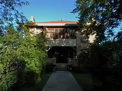 Mount View |
December 8, 1997 (#97001534) |
610 S. Jefferson St. 44°47′30″N 106°57′40″W |
Sheridan | |
| 16 | Odd Fellows Hall | December 9, 1980 (#80004052) |
Jackson St. 44°40′46″N 106°59′27″W |
Big Horn | ||
| 17 | Quarter Circle A Ranch | August 10, 1976 (#76001961) |
2 mi (3.2 km) southwest of Big Horn 44°38′26″N 107°00′53″W |
Big Horn | ||
| 18 | Robinson-Smith House | 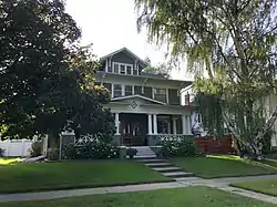 Robinson-Smith House |
April 26, 2016 (#16000207) |
520 South Brooks St. 44°47′32″N 106°57′27″W |
Sheridan | |
| 19 | St. Peter's Episcopal Church | 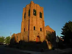 St. Peter's Episcopal Church |
May 8, 2013 (#13000266) |
1 S. Tschirgi 44°47′50″N 106°57′29″W |
Sheridan | |
| 20 | Sheridan County Courthouse | 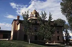 Sheridan County Courthouse |
November 15, 1982 (#82001836) |
Burkett and Main St. 44°47′42″N 106°57′21″W |
Sheridan | |
| 21 | Sheridan County Fairgrounds Historic District | 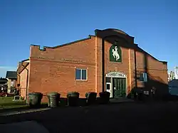 Sheridan County Fairgrounds Historic District |
August 10, 2011 (#11000533) |
1753 Victoria St. 44°48′16″N 106°58′53″W |
Sheridan | |
| 22 | Sheridan Flouring Mills, Inc. | 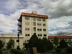 Sheridan Flouring Mills, Inc. |
December 8, 1997 (#97001533) |
2161 Coffeen Ave. 44°46′28″N 106°56′28″W |
Sheridan | |
| 23 | Sheridan Inn | .jpg.webp) Sheridan Inn |
October 15, 1966 (#66000762) |
Broadway and 5th St. 44°48′21″N 106°57′09″W |
Sheridan | |
| 24 | Sheridan Main Street Historic District | 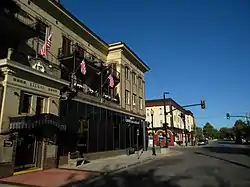 Sheridan Main Street Historic District |
November 9, 1982 (#82001837) |
Main St. from Burkitt to Mandel Sts. 44°47′55″N 106°57′19″W |
Sheridan | |
| 25 | Sheridan Railroad Historic District | 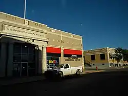 Sheridan Railroad Historic District |
November 12, 2004 (#04001234) |
201-841 Broadway, 508-955 N. Gould 44°48′19″N 106°57′11″W |
Sheridan | |
| 26 | Trail End | 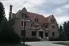 Trail End |
February 26, 1970 (#70000675) |
400 Claredon Ave. 44°48′05″N 106°57′58″W |
Sheridan | |
| 27 | Susan Wissler House | 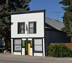 Susan Wissler House |
March 8, 1984 (#84003703) |
406 Main St. 44°52′27″N 107°15′43″W |
Dayton |
See also
| Wikimedia Commons has media related to National Register of Historic Places in Sheridan County, Wyoming. |
References
- The latitude and longitude information provided in this table was derived originally from the National Register Information System, which has been found to be fairly accurate for about 99% of listings. Some locations in this table may have been corrected to current GPS standards.
- "National Register of Historic Places: Weekly List Actions". National Park Service, United States Department of the Interior. Retrieved on January 29, 2021.
- Numbers represent an alphabetical ordering by significant words. Various colorings, defined here, differentiate National Historic Landmarks and historic districts from other NRHP buildings, structures, sites or objects.
- The eight-digit number below each date is the number assigned to each location in the National Register Information System database, which can be viewed by clicking the number.
- Some listings on the NRHP are highly sensitive sites and may be subject to looting or vandalism. The NRHP lists this site as "Address Restricted."
| Topics | |
|---|---|
| Lists by state |
|
| Lists by insular areas | |
| Lists by associated state | |
| Other areas | |
| Related | |
| |
Municipalities and communities of Sheridan County, Wyoming, United States | ||
|---|---|---|
| City | | |
| Towns | ||
| CDPs | ||
| Unincorporated communities | ||
| ||
This article is issued from Wikipedia. The text is licensed under Creative Commons - Attribution - Sharealike. Additional terms may apply for the media files.