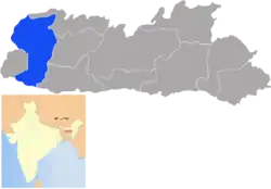
West Garo Hills district
West Garo Hills is an administrative district in Garo Hills of the state of Meghalaya in India. Tura town is the administrative headquarters of the district. The district occupies an area of 3714 km². In 2011 its population was 643,291. As of 2011 it is the second most populous district of Meghalaya (out of 7), after East Khasi Hills.[1]
West Garo Hills district
West Garo | |
|---|---|
District of Meghalaya | |
 Location of West Garo Hills district in Meghalaya | |
| Country | India |
| State | Meghalaya |
| Headquarters | Tura, India |
| Government | |
| • Vidhan Sabha constituencies | 7 |
| Area | |
| • Total | 3,714 km2 (1,434 sq mi) |
| Population (2011) | |
| • Total | 643,291 |
| • Density | 170/km2 (450/sq mi) |
| Demographics | |
| • Literacy | 53% |
| Time zone | UTC+05:30 (IST) |
| Website | westgarohills |
West Garo Hills district is located at the westernmost part of Meghalaya. The district is bounded by East Garo Hills district on the east, by South Garo Hills district on the south-east, Goalpara district of Assam state on the north and north-west and Bangladesh on the south.
History
In 22 October 1976 the Garo Hills district was bifurcated into two districts: West Garo Hills district and East Garo Hills district. The West Garo Hills district was further divided into two districts: the present day West Garo Hills district and South Garo Hills district in June 1992.
Economy
In 2006 the Ministry of Panchayati Raj named West Garo Hills one of the country's 250 most backward districts (out of a total of 640).[2] It is one of the three districts in Meghalaya currently receiving funds from the Backward Regions Grant Fund Programme (BRGF).[2]
Mahendraganj international border crossing
Mahendraganj-Baksiganj international border crossing is at Mahendraganj town in West Garo HIlls district in India on NH12 to Bakshiganj is an international crossing being further developed in the Bharatmala routes (slide 22).[3]
Phulbari-Dhubri Bridge on Brahmaputra river
- Phulbari-Dhubri Bridge,: After the completion of Phulbari-Dhubri Bridge on Brahmaputra river, the district will be connected to West Bengal via Dhubri, Assam. A rail line extending from Dhubri till Mahendraganj International border can change the economy of the entire region. The Phulbari-Dhubri Bridge will be the longest bridge in the country.
Divisions
Administrative divisions
West Garo Hills district is divided into six blocks, after the creation of South West Garo Hills district :[4]
| Name | Headquarters | Population | Location |
| Dadenggiri | Dadenggiri | 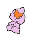 | |
| Dalu | Dalu | 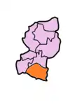 | |
| Gambegre | Gambegre | 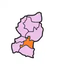 | |
| Rongram | Asananggiri | 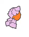 | |
| Selsella | Selsella |  | |
| Tikrikilla | Tikrikilla |  |
Demographics
According to the 2011 census West Garo Hills district has a population of 643,291,[1] roughly equal to the nation of Montenegro[5] or the US state of Vermont.[6] This gives it a ranking of 514th in India (out of a total of 640).[1] The district has a population density of 173 inhabitants per square kilometre (450/sq mi) .[1] Its population growth rate over the decade 2001-2011 was 24.02%.[1] West Garo Hills has a sex ratio of 979 females for every 1000 males,[1] and a literacy rate of 68.38%.[1]
Tura has a mixed population of Garos or Achiks (as they prefer to call themselves), Bengalis, Nepalis, Assamese, members of other ethnic groups such as the Hajong, Rabhas and Koches, Bodo and a fair sprinkling of South Indians in the Catholic Church, the teaching profession and the paramilitary forces.
Languages
Languages in West Garo include A'Tong, a Tibeto-Burman language spoken by 10,000 people in Bangladesh and India.[7] Apart from Garo language, which has the highest number of speakers in the district, a large number of people speak Deshi language (a dialect of Assamese) and Bengali language. The Muslim non-tribals along with the Rabhas, Koches and Hajongs of the plain belt mostly study Assamese as their MIL, whereas hindu non-tribals study Bengali as their MIL. Very few hindi speakers are also there in the district.
Culture
Places of Interest
Some places of interest in Garo Hills are Siju Cave, Nokrek Peak, Siju Bird Sanctuary, Imilsang Dare falls, Sosibibra and Rongdong falls.
Some places worth visiting in West Garo Hills are 1. Bhaitbari / Wadagokgre Excavation Site, 2. Pelga Waterfalls, 3. Tura Peak Range, 4. Nokrek Peak, 5. Nokpante Institution, 6. Typical Garo Villages 7. Rongai Valley 8. Phulbari River side.
Flora and fauna
In 1986 West Garo Hills district, along with its sister districts South and East Garo Hills, became home to Nokrek National Park. The park has an area of 47 km2 (18.1 sq mi).[8]
Prominent Personalities of West Garo Hills
- P A Sangma, Most famous leader from Meghalaya. He was the Speaker of Indian Parliament and Chief Minister of Meghalaya.
- Conrad Sangma, Present Chief Minister of Meghalaya.
- Agatha Sangma, Ex Union Minister and present MP from Garo Hills. She is also the first woman MP from Meghalaya.
- Justice Jangsan Sangma, He was a judge in the Gauhati High Court. The only person so far among the Garos.
- Benjamin Chandra Momin, The first Member of Assam legislative Assembly ( 1937) representing Garo Hills.
- Jobang D Marak, He was the another Member of the first Assam Legislative Assembly (1937) representing Garo Hills.
- Mody Marak, He was a member of the second Assam Assembly (1946) representing Garo Hills.
- Moniram Marak, He was the other member of the second Assam Assembly (1946) representing Garo Hills.
- Miriam D Shira, The first Garo woman legislator of Meghalaya. Shira exhibited an exemplary example to the Garo society by plunging into politicians, when Meghalaya was carved out of Assam in 1972. There were very few women in active politics then. Though she did not win the election but led other women to follow suit. She successfully contested the by-election to Songsak constituency in 1975 and became the first Garo women to be elected as legislator. In 1978, Shira won for the second term from Songsak constituency and served as Minister of State under Chief Minister Darwin Pugh. When Pugh’s government was toppled in 1980, Shira was elected as the Deputy Speaker of Meghalaya Legislative Assembly. She was first amongst the women politicians, who held the post. In 1988, Shira decided to contest from Rajabala and won the election with huge margin. She served as cabinet minister under BB Lyngdoh till the expiry of the term.
- Akramuz Zaman, A freedom fighter, Mr A. Zaman was the first leader of opposition of Meghalaya. He was a founding member of Garo Hills Autonomous District Council in 1952. He was a popular leader and was a founding member of Meghalaya Legislative Assembly representing Phulbari constituency. He was also the first Chairman of Meghalaya Co-Op Society. He established Phulbari JN High School, Phulbari Hospital, Mecofed, Ginning Mill of Shyamnagar and Azad Library. He was a visionary leader and a scholar fondly called as "Zaman Saheb".
- Jainab Zaman, She was the first lady from Garo hills to be a graduate. Born in Phulbari (elder sister of Akramuz Zaman), she did her graduation from Lady Brabourne College, Calcutta in the year 1944. Later on she also did her Masters and BT from Calcutta University.
- Dr. Ashrafuz Zaman, From Phulbari. A fellow of the Royal College of Surgery (FRCS), London. He was the first Doctor from Garo Hills who went abroad for higher education during the 1960s.
- Ashiquz Zaman, Son of Dr Safiquz Zaman of Phulbari. He was the first person from the district to clear IAS Examination.
- Larry Sangma, A budding cricketer. Played for Meghalaya team in the Syed Mushtaq Ali Trophy and Vijay Hazare Trophy.
- Chenhgkam Sangma, A first class cricketer. Played Ranji Trophy for Meghalaya.
- Dominic Megam Sangma, A Post -graduate from Satyajit Roy Film & Telivision Institute, Mr Dominic Sangma made many documentary and short movies. His films were exhibited in many international film Festivals including Cannes. He is a faculty of Film & Television Institute, Itanagar.
- Balam D Sangma, A senior popular singer of Garo Hills.
- Semeri Alva B Sangma, A reputed journalist and an adventurist, Ms Alva is the editor, publisher and the proprietor of A·chik Songbad, a Garo newspaper besides being a stringer for NDTV 24x7. was the only lady driver in India to have featured in Apollo Flight of the Hawks, an Extreme Adventure Reality Series of the National Geographic Channel in 2010.
References
- "District Census 2011". Census2011.co.in. 2011. Retrieved 30 September 2011.
- Ministry of Panchayati Raj (8 September 2009). "A Note on the Backward Regions Grant Fund Programme" (PDF). National Institute of Rural Development. Archived from the original (PDF) on 5 April 2012. Retrieved 27 September 2011.
- Bharatmala
- Meghalaya Administrative Divisions (PDF) (Map). The Registrar General & Census Commissioner, India, New Delhi, Ministry of Home Affairs, Government of India. 2011. Retrieved 29 September 2011.
- US Directorate of Intelligence. "Country Comparison:Population". Retrieved 1 October 2011.
Montenegro 661,807 July 2011 est.
- "2010 Resident Population Data". U. S. Census Bureau. Retrieved 30 September 2011.
Vermont 625,741
- M. Paul Lewis, ed. (2009). "A'Tong: A language of India". Ethnologue: Languages of the World (16th ed.). Dallas, Texas: SIL International. Retrieved 28 September 2011.
- Indian Ministry of Forests and Environment. "Protected areas: Meghalaya". Archived from the original on 23 August 2011. Retrieved 25 September 2011.
External links
Places adjacent to West Garo Hills district | ||||||||||
|---|---|---|---|---|---|---|---|---|---|---|
| ||||||||||
| State symbols | |
|---|---|
| Topics | |
| Administration |
|
| Divisions |
|
| Districts | |
| Municipalities | |
| |