Shoshone County, Idaho
Shoshone County is a county in the U.S. state of Idaho. As of the 2010 census, the population was 12,765.[1] The county seat is Wallace,[2] and the largest city is Kellogg. The county was established in 1864, named for the Native American Shoshone tribe.
Shoshone County | |
|---|---|
.jpg.webp) | |
 Seal | |
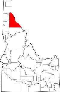 Location within the U.S. state of Idaho | |
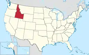 Idaho's location within the U.S. | |
| Coordinates: 47°21′N 115°53′W | |
| Country | |
| State | |
| Founded | February 4, 1864 |
| Named for | Shoshone tribe |
| Seat | Wallace |
| Largest city | Kellogg |
| Area | |
| • Total | 2,635 sq mi (6,820 km2) |
| • Land | 2,634 sq mi (6,820 km2) |
| • Water | 5.5 sq mi (14 km2) 0.2% |
| Population (2010) | |
| • Total | 12,765 |
| • Estimate (2018) | 12,796 |
| • Density | 4.8/sq mi (1.9/km2) |
| Time zone | UTC−8 (Pacific) |
| • Summer (DST) | UTC−7 (PDT) |
| Congressional district | 1st |
| Website | www |
Shoshone County is commonly referred to as the Silver Valley, due to its century-old mining history. The Silver Valley is famous nationwide for the vast amounts of silver, lead, and zinc mined from it.
History
Shoshone County was formed under the Territory of Washington on January 9, 1861.[3] Washington Territory legislators established the county in anticipation of the gold rush that occurred after the discovery of gold at Pierce in October, 1860. Their location of the northern boundary at a line drawn due east from the mouth of the Clearwater River, unknowingly placed the emerging mining settlement at Pierce outside of the county's boundaries while residents of the new Mormon settlement at Franklin were unknowingly within the established boundaries. Regardless of the geographic reality, the county seat was at Pierce. Growth at Pierce was so rapid that Shoshone County boasted the largest vote of any county within Washington Territory at the territorial election of July 8, 1861. In less than a year, Shoshone County contained additional settlements at Lewiston, Elk City, Newsome, and Florence. On December 20, 1861, Nez Perce and Idaho counties were created from most of the original territory of Shoshone County. On the following day, Shoshone's boundaries were shifted northward, containing most of present-day Clearwater County and a portion of present-day Shoshone County.[4][5]
This new boundary alignment left the existing settlement at Pierce and the new settlement of Orofino as the county's only settlements. The county's population dwindled as prospectors abandoned Pierce for gold prospects at Elk City and Florence. Idaho Territory was created in 1863 and the first census of the territory in that year enumerated only 574 residents in Shoshone County.[6] The county boundaries were expanded to include the Silver Valley by the legislative assembly of Idaho Territory when it officially created Shoshone County on February 4, 1864. The expanded territory contained no population at the second census of Idaho Territory in 1864. All of the county's 276 residents were located at Pierce and Orofino.[7]
Until 1904, Shoshone County included present-day Clearwater County to the south. That portion was annexed by Nez Perce County for several years and then was established as a new county in 1911.[8] When the Silver Valley population rose dramatically in the 1880s, the seat was moved to Murray in 1884 (and to Wallace in 1898) to better serve the majority of the county's population. The southern area's population increased with homesteading in the Weippe area in the late 1890s. The vast distance and time required for travel to Wallace from the Clearwater River area prompted the southern portion to move to Nez Perce County.
Hard rock miners in Shoshone County protested wage cuts with a strike in 1892. After several lost their lives in a shooting war provoked by discovery of a company spy, the U.S. army forced an end to the strike. Hostilities erupted once again in 1899 when, in response to the company firing seventeen men for joining the union, the miners dynamited the Bunker Hill & Sullivan mill. Again, lives were lost, and the U.S. Army intervened, requested by Governor Frank Steunenberg, as the Idaho National Guard troops were still stationed in the Philippines following the Spanish–American War. Steunenberg was assassinated outside his residence in Caldwell in 1905, nearly five years after leaving office, and the subsequent trials in Boise in 1907 made national headlines.
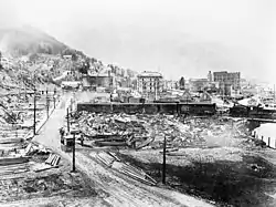
Much of the county was burned in the Great Fire of 1910, including part of the town of Wallace.[9]
Geography
According to the U.S. Census Bureau, the county has an area of 2,635 square miles (6,820 km2), of which 2,630 square miles (6,800 km2) is land and 5.5 square miles (14 km2) (0.2%) is water.[10]
Adjacent counties
- Bonner County - north
- Sanders County, Montana - northeast/Mountain Time Border
- Mineral County, Montana - southeast/Mountain Time Border
- Clearwater County - south
- Latah County - southwest
- Benewah County - west
- Kootenai County - northwest
National protected areas
- Clearwater National Forest (part)
- Coeur d'Alene National Forest (part)
- St. Joe National Forest (part)
Demographics
| Historical population | |||
|---|---|---|---|
| Census | Pop. | %± | |
| 1870 | 722 | — | |
| 1880 | 469 | −35.0% | |
| 1890 | 5,382 | 1,047.5% | |
| 1900 | 11,950 | 122.0% | |
| 1910 | 13,963 | 16.8% | |
| 1920 | 14,250 | 2.1% | |
| 1930 | 19,060 | 33.8% | |
| 1940 | 21,230 | 11.4% | |
| 1950 | 22,806 | 7.4% | |
| 1960 | 20,876 | −8.5% | |
| 1970 | 19,718 | −5.5% | |
| 1980 | 19,226 | −2.5% | |
| 1990 | 13,931 | −27.5% | |
| 2000 | 13,771 | −1.1% | |
| 2010 | 12,765 | −7.3% | |
| 2018 (est.) | 12,796 | [11] | 0.2% |
| U.S. Decennial Census[12] 1790-1960[13] 1900-1990[14] 1990-2000[15] 2010-2018[1] | |||
2000 census
As of the census[16] of 2000, there were 13,771 people, 5,906 households, and 3,856 families living in the county. The population density was 5 people per square mile (2/km2). There were 7,057 housing units at an average density of 3 per square mile (1/km2). The racial makeup of the county was 95.84% White, 0.11% Black or African American, 1.52% Native American, 0.23% Asian, 0.07% Pacific Islander, 0.49% from other races, and 1.74% from two or more races. 1.93% of the population were Hispanic or Latino of any race. 22.1% were of German, 14.0% American, 11.3% English, 9.7% Irish and 5.9% Norwegian ancestry.
There were 5,906 households, out of which 26.70% had children under the age of 18 living with them, 52.70% were married couples living together, 8.10% had a female householder with no husband present, and 34.70% were non-families. 29.40% of all households were made up of individuals, and 13.60% had someone living alone who was 65 years of age or older. The average household size was 2.30 and the average family size was 2.82.
In the county, the population was spread out, with 22.90% under the age of 18, 6.70% from 18 to 24, 25.50% from 25 to 44, 27.40% from 45 to 64, and 17.40% who were 65 years of age or older. The median age was 42 years. For every 100 females there were 99.40 males. For every 100 females age 18 and over, there were 97.00 males.
The median income for a household in the county was $28,535, and the median income for a family was $35,694. Males had a median income of $30,439 versus $18,831 for females. The per capita income for the county was $15,934. About 12.40% of families and 16.40% of the population were below the poverty line, including 21.80% of those under age 18 and 10.00% of those age 65 or over.
2010 census
As of the 2010 United States Census, there were 12,765 people, 5,605 households, and 3,511 families living in the county.[17] The population density was 4.9 inhabitants per square mile (1.9/km2). There were 7,061 housing units at an average density of 2.7 per square mile (1.0/km2).[18] The racial makeup of the county was 95.4% white, 1.4% American Indian, 0.4% Asian, 0.2% black or African American, 0.1% Pacific islander, 0.5% from other races, and 2.0% from two or more races. Those of Hispanic or Latino origin made up 3.0% of the population.[17] In terms of ancestry, 32.2% were German, 17.6% were Irish, 13.5% were English, 6.4% were Norwegian, and 4.4% were American.[19]
Of the 5,605 households, 25.4% had children under the age of 18 living with them, 48.5% were married couples living together, 8.7% had a female householder with no husband present, 37.4% were non-families, and 31.3% of all households were made up of individuals. The average household size was 2.25 and the average family size was 2.79. The median age was 46.2 years.[17]
The median income for a household in the county was $36,654 and the median income for a family was $44,685. Males had a median income of $38,315 versus $25,273 for females. The per capita income for the county was $19,020. About 13.8% of families and 17.9% of the population were below the poverty line, including 22.5% of those under age 18 and 8.3% of those age 65 or over.[20]
Politics
Shoshone County was historically a Democratic-leaning county, but in recent years has voted for Republican presidential candidates, while favoring Democratic candidates locally and statewide. The county polled a majority for Democratic Gubernatorial candidate Jerry Brady and Democratic Senatorial candidate Larry LaRocco, but Barack Obama lost in 2008 by an eight-point margin.
| Year | Republican | Democratic | Third parties |
|---|---|---|---|
| 2020 | 69.7% 4,216 | 28.0% 1,693 | 2.3% 140 |
| 2016 | 64.4% 3,297 | 27.0% 1,384 | 8.6% 439 |
| 2012 | 52.4% 2,699 | 44.2% 2,277 | 3.3% 172 |
| 2008 | 52.1% 2,953 | 44.5% 2,521 | 3.4% 193 |
| 2004 | 54.8% 2,922 | 43.7% 2,331 | 1.6% 84 |
| 2000 | 53.5% 2,879 | 41.3% 2,225 | 5.2% 281 |
| 1996 | 26.7% 1,588 | 50.1% 2,981 | 23.3% 1,385 |
| 1992 | 22.0% 1,441 | 48.6% 3,182 | 29.4% 1,925 |
| 1988 | 38.2% 2,134 | 60.5% 3,379 | 1.3% 73 |
| 1984 | 50.2% 3,156 | 48.3% 3,033 | 1.5% 95 |
| 1980 | 52.0% 3,994 | 40.4% 3,102 | 7.5% 579 |
| 1976 | 51.7% 3,570 | 46.6% 3,216 | 1.8% 123 |
| 1972 | 53.7% 3,868 | 41.9% 3,020 | 4.4% 319 |
| 1968 | 40.6% 3,080 | 50.7% 3,850 | 8.7% 657 |
| 1964 | 35.7% 2,884 | 64.3% 5,194 | |
| 1960 | 40.7% 3,432 | 59.3% 5,001 | |
| 1956 | 50.8% 4,598 | 49.2% 4,448 | |
| 1952 | 51.9% 5,119 | 47.5% 4,684 | 0.6% 59 |
| 1948 | 38.7% 3,200 | 54.1% 4,472 | 7.1% 589 |
| 1944 | 37.4% 3,162 | 62.5% 5,290 | 0.1% 11 |
| 1940 | 34.7% 3,525 | 64.5% 6,565 | 0.8% 82 |
| 1936 | 28.3% 2,146 | 70.9% 5,377 | 0.8% 59 |
| 1932 | 39.5% 2,902 | 59.2% 4,347 | 1.4% 100 |
| 1928 | 59.6% 3,648 | 39.7% 2,430 | 0.6% 39 |
| 1924 | 51.0% 3,034 | 14.0% 835 | 34.9% 2,078 |
| 1920 | 64.2% 3,112 | 35.8% 1,733 | |
| 1916 | 33.9% 2,431 | 59.1% 4,239 | 7.0% 501 |
| 1912 | 27.7% 1,399 | 32.3% 1,634 | 40.0% 2,021[lower-alpha 1] |
| 1908 | 55.1% 3,256 | 35.7% 2,109 | 9.3% 547 |
| 1904 | 62.0% 3,095 | 22.4% 1,116 | 15.6% 778 |
| 1900 | 44.3% 2,378 | 55.7% 2,994 |
Communities
Unincorporated communities
Ghost town
Ski areas
See also
Notes
- The leading "other" candidate, Progressive Theodore Roosevelt, received 1,159 votes while Socialist Eugene Debs received 834 votes and Prohibition candidate Eugene Chafin received 28 votes.
References
- "State & County QuickFacts". United States Census Bureau. Retrieved July 1, 2014.
- "Find a County". National Association of Counties. Archived from the original on May 31, 2011. Retrieved June 7, 2011.
- "Session Laws of the Territory of Washington" (PDF). James Lodge Public Printer. Retrieved 10 February 2016.
- "Early Shoshone County" (PDF). Idaho State Historical Society. Retrieved February 10, 2016.
- "Session Laws of the Territory of Washington" (PDF). A.M. Poe, Public Printer. Retrieved February 10, 2016.
- "1863 Census" (PDF). Idaho State Historical Society. Archived from the original (PDF) on 2013-01-24. Retrieved 2016-02-10.
- "1864 Census" (PDF). Idaho State Historical Society. Archived from the original (PDF) on February 3, 2013. Retrieved February 10, 2016.
- "Clearwater County, Idaho|History". www.clearwatercounty.org. Retrieved April 4, 2018.
- Pyne, Stephen J. (2008). Year of the Fires: The Story of the Great Fires of 1910. Missoula, Montana: Mountain Press Publishing Company. ISBN 978-0-87842-544-0.
- "US Gazetteer files: 2010, 2000, and 1990". United States Census Bureau. February 12, 2011. Retrieved April 23, 2011.
- "Population and Housing Unit Estimates". Retrieved September 6, 2019.
- "U.S. Decennial Census". United States Census Bureau. Retrieved July 1, 2014.
- "Historical Census Browser". University of Virginia Library. Retrieved July 1, 2014.
- "Population of Counties by Decennial Census: 1900 to 1990". United States Census Bureau. Retrieved July 1, 2014.
- "Census 2000 PHC-T-4. Ranking Tables for Counties: 1990 and 2000" (PDF). United States Census Bureau. Retrieved July 1, 2014.
- "U.S. Census website". United States Census Bureau. Retrieved January 31, 2008.
- "DP-1 Profile of General Population and Housing Characteristics: 2010 Demographic Profile Data". United States Census Bureau. Archived from the original on February 13, 2020. Retrieved January 9, 2016.
- "Population, Housing Units, Area, and Density: 2010 - County". United States Census Bureau. Archived from the original on February 13, 2020. Retrieved January 9, 2016.
- "DP02 SELECTED SOCIAL CHARACTERISTICS IN THE UNITED STATES – 2006-2010 American Community Survey 5-Year Estimates". United States Census Bureau. Archived from the original on February 13, 2020. Retrieved January 9, 2016.
- "DP03 SELECTED ECONOMIC CHARACTERISTICS – 2006-2010 American Community Survey 5-Year Estimates". United States Census Bureau. Archived from the original on February 13, 2020. Retrieved January 9, 2016.
- Leip, David. "Dave Leip's Atlas of U.S. Presidential Elections". uselectionatlas.org. Retrieved April 4, 2018.
Further reading
- John M. Henderson and William S. Shiach, with Harry B. Averill, An Illustrated History of North Idaho: Embracing Nez Perces, Idaho, Latah, Kootenai and Shoshone Counties, State of Idaho. n.c. [Chicago]: Western Historical Publishing Co., 1903.
External links
Places adjacent to Shoshone County, Idaho | ||||||||||
|---|---|---|---|---|---|---|---|---|---|---|
| ||||||||||
Municipalities and communities of Shoshone County, Idaho, United States | ||
|---|---|---|
| Cities | Map of Idaho highlighting Shoshone County | |
| Unincorporated communities | ||
| Footnotes | ‡This populated place also has portions in an adjacent county or counties | |
| ||
Boise (capital) | ||
| Topics |
| |
| Society | ||
| Regions | ||
| Larger cities | ||
| Smaller cities | ||
| Counties |
| |
| Authority control |
|---|