Elmore County, Idaho
Elmore County is a county in the U.S. state of Idaho. As of the 2010 census, the population was 27,038.[1] The largest city and county seat is Mountain Home.[2]
Elmore County | |
|---|---|
 | |
 Seal | |
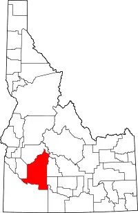 Location within the U.S. state of Idaho | |
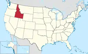 Idaho's location within the U.S. | |
| Coordinates: 43°20′N 115°28′W | |
| Country | |
| State | |
| Founded | February 7, 1889 |
| Named for | The Ida Elmore mines, producer of silver and gold in the 1860s |
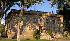
| Seat | Mountain Home |
| Largest city | Mountain Home |
| Area | |
| • Total | 3,101 sq mi (8,030 km2) |
| • Land | 3,075 sq mi (7,960 km2) |
| • Water | 26 sq mi (70 km2) 0.8% |
| Population (2010) | |
| • Total | 27,038 |
| • Estimate (2019) | 27,511 |
| • Density | 8.7/sq mi (3.4/km2) |
| Time zone | UTC−7 (Mountain) |
| • Summer (DST) | UTC−6 (MDT) |
| Congressional district | 2nd |
| Website | elmorecounty |
Elmore County comprises the Mountain Home, ID Micropolitan Statistical Area, which is also included in the Boise-Mountain Home-Ontario, ID-OR Combined Statistical Area.
History
Elmore County was established February 7, 1889, with its county seat at Rocky Bar. It is named after the Ida Elmore mines, the area's greatest silver and gold producer of the 1860s, located near Silver City in Owyhee County.[3][4]
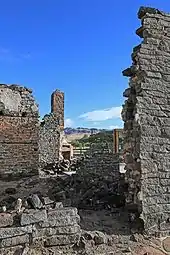
While the Oregon Trail crossed the Snake River in Elmore County, at Three Island Crossing near Glenns Ferry, the significant early settlements of Elmore County were mining settlements located primarily in northern Elmore County surrounding the ghost town of Rocky Bar. Settlement at Rocky Bar commenced in 1863 with the settlement having 560 residents at the Territorial Census of that year.[5] Nearby, Atlanta was settled in 1864.[6] Elmore County north of the Snake River was originally part of Alturas County when it was created in 1864 and Rocky Bar became its county seat. The portion of Elmore County south of the Snake River was within Owyhee County until 1930. A small portion of Ada County was also annexed in 1948, bringing Elmore to its present boundary.[7] The settlement at Rocky Bar was impacted by poor management by mining companies, mining lawsuits, and its geographic remoteness between 1869 and 1880. The Wood River experienced a surge in settlement at Hailey starting in 1880 that led to Rocky Bar's loss of the county seat to Hailey in 1882.[8][9] Rocky Bar would briefly become a county seat upon the creation of Elmore County in 1889.
A station on the overland stage route, originally named Rattlesnake, was moved west to the railroad line and became Mountain Home. On February 4, 1891, the county seat was moved to Mountain Home.[10]
Construction of what would become Mountain Home Air Force Base was begun in October 1942, 12 miles (19 km) southwest of Mountain Home. The base officially opened in August 1943 as a training base for bombers, and was an operational base under SAC through 1965. It became a fighter base in 1966 under Tactical Air Command, now the Air Combat Command.
Anderson Ranch Dam is east of Mountain Home on the South Fork of the Boise River. At the time of its completion in 1950, it was the world's highest earthfill dam.[11]
Geography
According to the United States Census Bureau, the county has a total area of 3,101 square miles (8,030 km2), of which 3,075 square miles (7,960 km2) is land and 26 square miles (67 km2) (0.8%) is water.[12] Elmore County's highest point is Snowyside Peak at 10,651 feet (3,246 m) above sea level, located in the northeast corner of the county in the Sawtooth Wilderness. The lowest elevation in the county is the Snake River in the southwest corner, at less than 2,500 feet (760 m).
Adjacent counties
- Boise County - north
- Ada County - west
- Owyhee County - south
- Twin Falls County - southeast
- Gooding County - east
- Camas County - east
- Blaine County - northeast
- Custer County - northeast
National protected areas
- Boise National Forest (part)
- Sawtooth National Forest (part)
- Sawtooth National Recreation Area (part)
- Sawtooth Wilderness (part)
- Snake River Birds of Prey National Conservation Area (part)
Demographics
| Historical population | |||
|---|---|---|---|
| Census | Pop. | %± | |
| 1890 | 1,870 | — | |
| 1900 | 2,286 | 22.2% | |
| 1910 | 4,785 | 109.3% | |
| 1920 | 5,087 | 6.3% | |
| 1930 | 4,491 | −11.7% | |
| 1940 | 5,518 | 22.9% | |
| 1950 | 6,687 | 21.2% | |
| 1960 | 16,719 | 150.0% | |
| 1970 | 17,479 | 4.5% | |
| 1980 | 21,565 | 23.4% | |
| 1990 | 21,205 | −1.7% | |
| 2000 | 29,130 | 37.4% | |
| 2010 | 27,038 | −7.2% | |
| 2019 (est.) | 27,511 | [13] | 1.7% |
| U.S. Decennial Census[14] 1790-1960[15] 1900-1990[16] 1990-2000[17] 2010-2018[1] | |||
2000 census
As of the census[18] of 2000, there were 29,130 people, 9,092 households, and 6,846 families living in the county. The population density was 10 people per square mile (4/km2). There were 10,527 housing units at an average density of 3 per square mile (1/km2). The racial makeup of the county was 85.37% White, 3.25% Black or African American, 0.89% Native American, 1.66% Asian, 0.19% Pacific Islander, 5.39% from other races, and 3.25% from two or more races. 11.99% of the population were Hispanic or Latino of any race. 16.8% were of German, 12.0% English, 9.2% American and 8.3% Irish ancestry.
There were 9,092 households, out of which 43.00% had children under the age of 18 living with them, 64.10% were married couples living together, 7.50% had a female householder with no husband present, and 24.70% were non-families. 20.70% of all households were made up of individuals, and 6.40% had someone living alone who was 65 years of age or older. The average household size was 2.76 and the average family size was 3.21.
In the county, the population was spread out, with 28.00% under the age of 18, 13.90% from 18 to 24, 36.00% from 25 to 44, 15.00% from 45 to 64, and 7.10% who were 65 years of age or older. The median age was 29 years. For every 100 females there were 123.20 males. For every 100 females age 18 and over, there were 130.60 males.
The median income for a household in the county was $35,256, and the median income for a family was $37,823. Males had a median income of $26,248 versus $21,309 for females. The per capita income for the county was $16,773. About 8.80% of families and 11.20% of the population were below the poverty line, including 15.00% of those under age 18 and 10.80% of those age 65 or over.
2010 census
As of the 2010 United States Census, there were 27,038 people, 10,140 households, and 7,135 families living in the county.[19] The population density was 8.8 inhabitants per square mile (3.4/km2). There were 12,162 housing units at an average density of 4.0 per square mile (1.5/km2).[20] The racial makeup of the county was 82.2% white, 2.8% Asian, 2.7% black or African American, 1.0% American Indian, 0.4% Pacific islander, 6.8% from other races, and 4.1% from two or more races. Those of Hispanic or Latino origin made up 15.2% of the population.[19] In terms of ancestry, 20.4% were German, 13.5% were English, 12.4% were Irish, and 9.0% were American.[21]
Of the 10,140 households, 38.6% had children under the age of 18 living with them, 56.6% were married couples living together, 9.4% had a female householder with no husband present, 29.6% were non-families, and 23.8% of all households were made up of individuals. The average household size was 2.60 and the average family size was 3.11. The median age was 30.0 years.[19]
The median income for a household in the county was $43,089 and the median income for a family was $50,840. Males had a median income of $34,126 versus $25,999 for females. The per capita income for the county was $20,388. About 9.2% of families and 12.0% of the population were below the poverty line, including 19.3% of those under age 18 and 7.8% of those age 65 or over.[22]
Communities
Cities
Census-designated place
Ghost town
Politics
| Year | Republican | Democratic | Third parties |
|---|---|---|---|
| 2016 | 68.3% 5,816 | 21.3% 1,814 | 10.5% 892 |
| 2012 | 65.3% 5,227 | 31.4% 2,513 | 3.3% 263 |
| 2008 | 66.8% 5,665 | 30.5% 2,591 | 2.7% 230 |
| 2004 | 74.6% 6,011 | 24.3% 1,959 | 1.1% 91 |
| 2000 | 70.2% 4,891 | 26.4% 1,840 | 3.4% 235 |
| 1996 | 53.1% 3,668 | 33.7% 2,324 | 13.2% 912 |
| 1992 | 44.8% 3,087 | 27.0% 1,858 | 28.2% 1,945 |
| 1988 | 63.5% 3,756 | 35.1% 2,078 | 1.4% 85 |
| 1984 | 75.3% 4,595 | 23.9% 1,458 | 0.9% 52 |
| 1980 | 64.9% 3,994 | 28.6% 1,760 | 6.5% 403 |
| 1976 | 55.5% 2,808 | 42.7% 2,164 | 1.8% 91 |
| 1972 | 66.6% 3,078 | 24.9% 1,153 | 8.5% 394 |
| 1968 | 50.6% 1,908 | 32.6% 1,230 | 16.7% 631 |
| 1964 | 44.6% 1,857 | 55.4% 2,310 | |
| 1960 | 47.7% 2,226 | 52.3% 2,440 | |
| 1956 | 51.3% 1,849 | 48.8% 1,759 | |
| 1952 | 52.7% 1,653 | 47.3% 1,484 | 0.1% 2 |
| 1948 | 34.1% 854 | 63.5% 1,589 | 2.4% 60 |
| 1944 | 38.6% 1,030 | 61.0% 1,627 | 0.4% 10 |
| 1940 | 39.7% 1,077 | 60.2% 1,632 | 0.2% 4 |
| 1936 | 28.9% 688 | 65.8% 1,567 | 5.3% 125 |
| 1932 | 31.9% 794 | 65.0% 1,615 | 3.1% 77 |
| 1928 | 59.9% 1,125 | 39.4% 739 | 0.7% 13 |
| 1924 | 38.0% 789 | 18.4% 381 | 43.6% 906 |
| 1920 | 55.1% 1,065 | 44.9% 867 | |
| 1916 | 35.5% 658 | 59.6% 1,104 | 4.9% 90 |
| 1912 | 27.1% 415 | 35.0% 536 | 37.9% 581[24] |
| 1908 | 42.5% 662 | 42.4% 660 | 15.0% 234 |
| 1904 | 53.1% 593 | 38.8% 433 | 8.1% 90 |
| 1900 | 41.0% 393 | 59.0% 565 |
References
- "State & County QuickFacts". United States Census Bureau. Archived from the original on July 17, 2011. Retrieved June 30, 2014.
- "Find a County". National Association of Counties. Archived from the original on May 31, 2011. Retrieved June 7, 2011.
- Idaho State Historical Society - J. Marion More - accessed June 15, 2009.
- "Idaho for the Curious", by Cort Conley, ©1982, ISBN 0-9603566-3-0, p.374-379
- "Idaho State Historical Society Reference Series: Census of 1863" (PDF). Idaho State Historical Society. Archived from the original (PDF) on December 28, 2016. Retrieved February 14, 2017.
- "Idaho State Historical Society Reference Series: Atlanta" (PDF). Idaho State Historical Society. Archived from the original (PDF) on 9 February 2017. Retrieved 14 February 2017.
- Idaho Atlas of Historical County Boundaries (PDF). Chicago: The Newberry Library. 2010. pp. 12, 80–83. Archived from the original (PDF) on February 14, 2017. Retrieved February 14, 2017.
- "Idaho State Historical Society Reference Series: Alturas County" (PDF). Idaho State Historical Society. Archived from the original (PDF) on 24 December 2016. Retrieved 14 February 2017.
- "Idaho State Historical Society Reference Series: Rocky Bar Mines" (PDF). Idaho State Historical Society. Archived from the original (PDF) on 14 February 2017. Retrieved 14 February 2017.
- idaho.gov - about Elmore County Archived December 20, 2004, at the Wayback Machine - accessed May 15, 2009
- USBR.gov Archived 2011-11-12 at the Wayback Machine - Anderson Ranch Dam - accessed September 27, 2011
- "US Gazetteer files: 2010, 2000, and 1990". United States Census Bureau. February 12, 2011. Retrieved April 23, 2011.
- "Population and Housing Unit Estimates". Retrieved July 28, 2019.
- "U.S. Decennial Census". United States Census Bureau. Retrieved June 30, 2014.
- "Historical Census Browser". University of Virginia Library. Retrieved June 30, 2014.
- "Population of Counties by Decennial Census: 1900 to 1990". United States Census Bureau. Retrieved June 30, 2014.
- "Census 2000 PHC-T-4. Ranking Tables for Counties: 1990 and 2000" (PDF). United States Census Bureau. Retrieved June 30, 2014.
- "U.S. Census website". United States Census Bureau. Retrieved January 31, 2008.
- "DP-1 Profile of General Population and Housing Characteristics: 2010 Demographic Profile Data". United States Census Bureau. Archived from the original on February 13, 2020. Retrieved January 9, 2016.
- "Population, Housing Units, Area, and Density: 2010 - County". United States Census Bureau. Archived from the original on February 13, 2020. Retrieved January 9, 2016.
- "DP02 SELECTED SOCIAL CHARACTERISTICS IN THE UNITED STATES – 2006-2010 American Community Survey 5-Year Estimates". United States Census Bureau. Archived from the original on February 13, 2020. Retrieved January 9, 2016.
- "DP03 SELECTED ECONOMIC CHARACTERISTICS – 2006-2010 American Community Survey 5-Year Estimates". United States Census Bureau. Archived from the original on February 13, 2020. Retrieved January 9, 2016.
- Leip, David. "Dave Leip's Atlas of U.S. Presidential Elections". uselectionatlas.org. Retrieved April 4, 2018.
- The leading "other" candidate, Progressive Theodore Roosevelt, received 382 votes while Socialist candidate Eugene Debs received 190 votes and Prohibition candidate Eugene Chafin 9 votes.
External links
| Wikimedia Commons has media related to Elmore County, Idaho. |
Places adjacent to Elmore County, Idaho | ||||||||||
|---|---|---|---|---|---|---|---|---|---|---|
| ||||||||||
Municipalities and communities of Elmore County, Idaho, United States | ||
|---|---|---|
| Cities | Map of Idaho highlighting Elmore County | |
| CDP | ||
| Unincorporated communities | ||
| ||
Boise (capital) | ||
| Topics |
| |
| Society | ||
| Regions | ||
| Larger cities | ||
| Smaller cities | ||
| Counties |
| |
| Authority control |
|---|