Owyhee County, Idaho
Owyhee County is a county in the southwestern corner of the U.S. state of Idaho. As of the 2010 census, the population was 11,526.[1] The county seat is Murphy,[2] and its largest city is Homedale.[3] In area it is the second-largest county in Idaho,[4] behind Idaho County.
Owyhee County | |
|---|---|
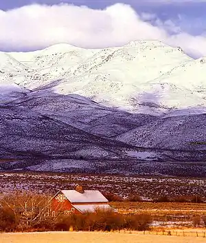 Reynolds Creek Experimental Watershed in the Owyhee Mountains about 50 miles southwest of Boise. | |
 Seal | |
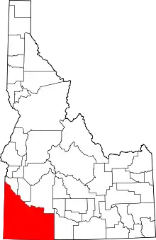 Location within the U.S. state of Idaho | |
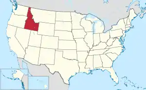 Idaho's location within the U.S. | |
| Coordinates: 42°34′N 116°10′W | |
| Country | |
| State | |
| Founded | December 31, 1863 |
| Named for | lost Hawaiian trappers |
| Seat | Murphy |
| Largest city | Homedale |
| Area | |
| • Total | 7,697 sq mi (19,940 km2) |
| • Land | 7,666 sq mi (19,850 km2) |
| • Water | 31 sq mi (80 km2) 0.4% |
| Population (2010) | |
| • Total | 11,526 |
| • Estimate (2018) | 11,693 |
| • Density | 1.5/sq mi (0.58/km2) |
| Time zone | UTC−7 (Mountain) |
| • Summer (DST) | UTC−6 (MDT) |
| Congressional district | 1st |
| Website | owyheecounty |
Owyhee County is part of the Boise metropolitan area and contains slightly more than half of the Duck Valley Indian Reservation, which extends over the Nevada border, into Elko County. The majority of the federally recognized Shoshone-Paiute Tribe that is associated with this reservation lives on the Nevada side; its tribal center is in Owyhee, Nevada.
History
This area was the territory of Western Shoshone, Northern Paiute, and Bannock peoples and their ancestors for thousands of years prior to the arrival of Americans. Conflicts over land use and resources led to the indigenous peoples being pushed aside.
On December 31, 1863, Owyhee County became the first county organized by the Idaho Territory Legislature. While Boise, Idaho, Nez Perce, and Shoshone counties were organized under the laws of Washington Territory, they were not recognized by the Idaho Territory until February 1864.[5][6][7] The original county seat at Ruby City was moved to nearby Silver City in 1867.[8]
Owyhee County's original boundary was the portion of Idaho Territory south of the Snake River and west of the Rocky Mountains.[9] Less than a month after the creation of Owyhee County, Oneida County was formed in January 1864 from the eastern portion of the county. The formation of Cassia County in 1879 took further territory in the east.
Owyhee County's history is closely linked to the mining boom that dominated Idaho Territory in the second half of the 19th century.[4] Silver City and Ruby City developed as boom towns. At its height in the 1880s, Owyhee County was among the most populous places in Idaho. Today it is among the least populous, at 1.4 persons per square mile (0.5 per km2).
Because of pressure from miners and settlers, the federal government made a treaty in 1877 with the Western Shoshone to cede land, and established what is now known as the Duck Valley Indian Reservation in this county and across the border in Elko County, Nevada. The reservation was expanded in 1886 to accommodate people of the Northern Paiute. In the 20th century, the tribes combined and are federally recognized as a single government; the majority of the people live on the Nevada side of the reservation.
Owyhee County gained its present boundaries in 1930 after an election approved moving a portion of it near Glenns Ferry and King Hill to neighboring Elmore County.[10] In 1934 the county seat was moved from the nearly abandoned Silver City to its present location in Murphy. In the 21st century, both Silver City and Ruby City are ghost towns, remnant of the mining boom.
Etymology
The name "Owyhee" derives from an early anglicization of the Hawaiian term "Hawaiʻi." When James Cook encountered what he named the Sandwich Islands (now the Hawaiian Islands) in 1778, he found them inhabited by Native Hawaiians, whom the Anglo-Americans referred to as "Owyhees." Noted for their hardy physique and maritime skills, numerous Native Hawaiians were hired as crew members aboard European and American vessels. Many Owyhee sailed to the American Northwest coast and found employment along the Columbia River, where they joined trapping expeditions or worked at some of the fur trade posts.
In 1819, three Owyhee joined Donald Mackenzie's Snake expedition, which went out annually into the Snake country for the North West Company, a Montreal-based organization of Canadian fur traders. The three Hawaiians left the main party during the winter of 1819–20 to explore the then unknown terrain of what since has been called the Owyhee River and mountains. They disappeared and were presumed dead; no further information regarding their whereabouts has been found. In memory of these Native Hawaiians, British fur trappers started to call the region "Owyhee" and the name stuck.[11][12]
Geography
According to the U.S. Census Bureau, the county has a total area of 7,697 square miles (19,940 km2), of which 7,666 square miles (19,850 km2) is land and 31 square miles (80 km2) (0.4%) is water.[13] It is the second-largest county in Idaho by area.
Nearly all of the county is high intermountain desert, with plentiful sagebrush and basalt canyons. The Owyhee Mountains in the west dominate the landscape, with Hayden Peak reaching 8,403 feet (2,561 m) above sea level. The lowest elevation is at the county's northwest corner, where the Snake River is just above 2,000 feet (610 m) at the Oregon border. The Snake forms most of the county's northern border from Oregon to just west of Glenns Ferry in Elmore County. A tributary of the Snake is the Bruneau River, which flows north from Nevada through the eastern section of the county. The Owyhee River starts in the southwestern part of the county and flows westward into Oregon; it eventually enters the Snake at the state border, south of Nyssa.
Adjacent counties
- Canyon County – north
- Ada County – north
- Elmore County – north
- Twin Falls County – east
- Elko County, Nevada – south/Pacific Time Border
- Humboldt County, Nevada – southwest/Pacific Time Border
- Malheur County, Oregon – west
Demographics
| Historical population | |||
|---|---|---|---|
| Census | Pop. | %± | |
| 1870 | 1,713 | — | |
| 1880 | 1,426 | −16.8% | |
| 1890 | 2,021 | 41.7% | |
| 1900 | 3,804 | 88.2% | |
| 1910 | 4,044 | 6.3% | |
| 1920 | 4,694 | 16.1% | |
| 1930 | 4,103 | −12.6% | |
| 1940 | 5,652 | 37.8% | |
| 1950 | 6,307 | 11.6% | |
| 1960 | 6,375 | 1.1% | |
| 1970 | 6,422 | 0.7% | |
| 1980 | 8,272 | 28.8% | |
| 1990 | 8,392 | 1.5% | |
| 2000 | 10,644 | 26.8% | |
| 2010 | 11,526 | 8.3% | |
| 2018 (est.) | 11,693 | [14] | 1.4% |
| U.S. Decennial Census[15] 1790–1960[16] 1900–1990[17] 1990–2000[18] 2010–2018[1] | |||
2000 census
As of the census[19] of 2000, there were 10,644 people, 3,710 households, and 2,756 families living in the county. The population density was 1.4 person per square mile (0.5/km2). There were 4,452 housing units at an average density of 1 per square mile (0/km2). The racial makeup of the county was 76.87% White, 0.15% Black or African American, 3.21% Native American, 0.47% Asian, 0.08% Pacific Islander, 16.50% from other races, and 2.72% from two or more races. 23.10% of the population were Hispanic or Latino of any race. 14.3% were of American, 12.5% German, 10.4% English and 8.1% Irish ancestry.
There were 3,710 households, out of which 37.80% had children under the age of 18 living with them, 61.20% were married couples living together, 8.70% had a female householder with no husband present, and 25.70% were non-families. 21.80% of all households were made up of individuals, and 9.50% had someone living alone who was 65 years of age or older. The average household size was 2.85 and the average family size was 3.35.
In the county, the population was spread out, with 31.90% under the age of 18, 8.50% from 18 to 24, 26.50% from 25 to 44, 20.90% from 45 to 64, and 12.10% who were 65 years of age or older. The median age was 33 years. For every 100 females, there were 109.00 males. For every 100 females age 18 and over, there were 107.60 males.
The median income for a household in the county was $28,339, and the median income for a family was $32,856. Males had a median income of $25,146 versus $20,718 for females. The per capita income for the county was $13,405. About 14.20% of families and 16.90% of the population were below the poverty line, including 20.80% of those under age 18 and 12.10% of those age 65 or over.
2010 census
As of the 2010 United States Census, there were 11,526 people, 4,076 households, and 2,954 families living in the county.[20] The population density was 1.5 inhabitants per square mile (0.58/km2). There were 4,781 housing units at an average density of 0.6 per square mile (0.23/km2).[21] The racial makeup of the county was 76.0% white, 4.3% American Indian, 0.5% Asian, 0.2% black or African American, 16.6% from other races, and 2.4% from two or more races. Those of Hispanic or Latino origin made up 25.8% of the population.[20] In terms of ancestry, 19.6% were American, 13.8% were German, 9.5% were English, and 9.4% were Irish.[22]
Of the 4,076 households, 36.9% had children under the age of 18 living with them, 57.3% were married couples living together, 9.6% had a female householder with no husband present, 27.5% were non-families, and 23.0% of all households were made up of individuals. The average household size was 2.79 and the average family size was 3.29. The median age was 36.0 years.[20]
The median income for a household in the county was $33,441 and the median income for a family was $36,405. Males had a median income of $31,404 versus $29,167 for females. The per capita income for the county was $17,373. About 18.0% of families and 22.2% of the population were below the poverty line, including 33.9% of those under age 18 and 10.8% of those age 65 or over.[23]
Communities
Cities
Census-designated place
Unincorporated communities
Ghost towns
Politics
Although Owyhee County was amongst the most Democratic in the state in its early history, it has like most of Idaho gradually turned overwhelmingly Republican. In no presidential election since 1940 has the county selected the Democratic candidate, and no Democrat since Jimmy Carter in 1976 has won more than one-third of the county's vote.
| Year | Republican | Democratic | Third parties |
|---|---|---|---|
| 2016 | 77.8% 3,052 | 15.1% 591 | 7.2% 282 |
| 2012 | 75.0% 2,794 | 22.4% 833 | 2.6% 97 |
| 2008 | 74.5% 3,024 | 23.3% 944 | 2.2% 90 |
| 2004 | 79.6% 2,859 | 19.1% 685 | 1.3% 46 |
| 2000 | 76.9% 2,450 | 19.5% 623 | 3.6% 115 |
| 1996 | 61.2% 2,033 | 26.9% 895 | 11.9% 395 |
| 1992 | 47.8% 1,469 | 22.3% 686 | 29.9% 917 |
| 1988 | 64.8% 1,707 | 32.2% 848 | 3.0% 79 |
| 1984 | 77.7% 2,141 | 20.8% 574 | 1.5% 40 |
| 1980 | 71.9% 2,257 | 23.3% 732 | 4.8% 151 |
| 1976 | 57.5% 1,519 | 39.9% 1,054 | 2.6% 68 |
| 1972 | 70.1% 1,630 | 19.9% 463 | 9.9% 231 |
| 1968 | 59.6% 1,385 | 24.2% 562 | 16.2% 376 |
| 1964 | 51.0% 1,216 | 49.0% 1,168 | |
| 1960 | 57.1% 1,500 | 42.9% 1,129 | |
| 1956 | 63.0% 1,468 | 37.1% 864 | |
| 1952 | 70.4% 1,813 | 29.5% 759 | 0.1% 3 |
| 1948 | 50.0% 969 | 47.8% 925 | 2.2% 43 |
| 1944 | 54.0% 983 | 45.3% 824 | 0.7% 12 |
| 1940 | 46.8% 1,031 | 52.6% 1,160 | 0.6% 14 |
| 1936 | 28.9% 500 | 64.0% 1,106 | 7.1% 122 |
| 1932 | 36.2% 583 | 59.6% 959 | 4.2% 68 |
| 1928 | 62.2% 918 | 36.1% 533 | 1.7% 25 |
| 1924 | 36.5% 564 | 20.0% 309 | 43.5% 671 |
| 1920 | 65.3% 971 | 34.7% 515 | |
| 1916 | 40.4% 594 | 52.8% 775 | 6.8% 100 |
| 1912 | 33.8% 515 | 37.3% 567 | 28.9% 440 |
| 1908 | 45.1% 604 | 48.5% 650 | 6.4% 86 |
| 1904 | 55.0% 663 | 32.6% 393 | 12.4% 149 |
| 1900 | 39.8% 584 | 60.2% 884 |
Gallery
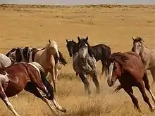 Wild Horses of Saylor Creek
 Round-up south of Bruneau
 Snake River Birds of Prey National Conservation Area
See also
References
- "State & County QuickFacts". United States Census Bureau. Archived from the original on July 17, 2011. Retrieved July 1, 2014.
- "Find a County". National Association of Counties. Retrieved June 7, 2011.
- "Historic Homedale". Archived from the original on 2012-03-01. Retrieved 2009-12-13.
- Colley, Evelyn Shaw (March 1, 1962). "Rich ore made Owyhee County boom". Lewiston Morning Tribune. (Idaho). p. 13.
- General Laws of Washington Territory, 1861 p.3-4
- General Laws of Washington Territory: 1863 p.4
- "An Act Defining the Boundary Lines of Counties west of the Rocky Mountains", Session Laws of Idaho Territory: 1863–1864, p. 628-630
- Ruby City – Idaho Ghost Town (accessed January 3, 2012)
- "An Act to Organize the County of Owyhee", Session Laws of Idaho Territory: 1863–1864, p. 624
- Sixteenth census of the United ... – United States. Bureau of the Census – Google Books (accessed January 3, 2010)
- "The Name Owyhee" (PDF). Idaho State Historical Society. August 1964. Archived from the original (PDF) on August 16, 2014. Retrieved January 1, 2015.
- "The Name "Owyhee"". www.3rd1000.com. Retrieved April 4, 2018.
- "US Gazetteer files: 2010, 2000, and 1990". United States Census Bureau. February 12, 2011. Retrieved April 23, 2011.
- "Population and Housing Unit Estimates". Retrieved September 6, 2019.
- "U.S. Decennial Census". United States Census Bureau. Retrieved July 1, 2014.
- "Historical Census Browser". University of Virginia Library. Retrieved July 1, 2014.
- "Population of Counties by Decennial Census: 1900 to 1990". United States Census Bureau. Retrieved July 1, 2014.
- "Census 2000 PHC-T-4. Ranking Tables for Counties: 1990 and 2000" (PDF). United States Census Bureau. Retrieved July 1, 2014.
- "U.S. Census website". United States Census Bureau. Retrieved January 31, 2008.
- "DP-1 Profile of General Population and Housing Characteristics: 2010 Demographic Profile Data". United States Census Bureau. Archived from the original on February 13, 2020. Retrieved January 9, 2016.
- "Population, Housing Units, Area, and Density: 2010 – County". United States Census Bureau. Archived from the original on February 13, 2020. Retrieved January 9, 2016.
- "DP02 SELECTED SOCIAL CHARACTERISTICS IN THE UNITED STATES – 2006–2010 American Community Survey 5-Year Estimates". United States Census Bureau. Archived from the original on February 13, 2020. Retrieved January 9, 2016.
- "DP03 SELECTED ECONOMIC CHARACTERISTICS – 2006–2010 American Community Survey 5-Year Estimates". United States Census Bureau. Archived from the original on February 13, 2020. Retrieved January 9, 2016.
- Leip, David. "Dave Leip's Atlas of U.S. Presidential Elections". uselectionatlas.org. Retrieved April 4, 2018.
Further reading
External links
- Owyhee County website
- Owyhee County Parcel Maps
- National Register of Historic Places for Owyhee County
- Owyhee County Historical Society
- County newspaper: The Owyhee Avalanche
Places adjacent to Owyhee County, Idaho | ||||||||||
|---|---|---|---|---|---|---|---|---|---|---|
| ||||||||||
Municipalities and communities of Owyhee County, Idaho, United States | ||
|---|---|---|
| Cities | Map of Idaho highlighting Owyhee County | |
| CDP | ||
| Unincorporated communities | ||
| Indian reservation | ||
| Ghost towns | ||
| Footnotes | ‡This populated place also has portions in an adjacent county or counties | |
| ||
Boise (capital) | ||
| Topics |
| |
| Society | ||
| Regions | ||
| Larger cities | ||
| Smaller cities | ||
| Counties |
| |
| Authority control |
|---|