Bélesta, Pyrénées-Orientales
Bélesta (Occitan: Bèl Estar) is a commune in the Pyrénées-Orientales department in southern France.
Bélesta
Belhestar | |
|---|---|
.jpg.webp) A general view of Bélesta | |
.svg.png.webp) Coat of arms | |
Location of Bélesta 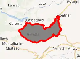
| |
 Bélesta  Bélesta | |
| Coordinates: 42°43′06″N 2°36′28″E | |
| Country | France |
| Region | Occitanie |
| Department | Pyrénées-Orientales |
| Arrondissement | Prades |
| Canton | La Vallée de l'Agly |
| Intercommunality | Communauté de communes de Roussillon Conflent |
| Government | |
| • Mayor (2014-2020) | Frédéric Bourniole |
| Area 1 | 20.52 km2 (7.92 sq mi) |
| Population (2017-01-01)[1] | 221 |
| • Density | 11/km2 (28/sq mi) |
| Time zone | UTC+01:00 (CET) |
| • Summer (DST) | UTC+02:00 (CEST) |
| INSEE/Postal code | 66019 /66720 |
| Elevation | 122–561 m (400–1,841 ft) (avg. 380 m or 1,250 ft) |
| 1 French Land Register data, which excludes lakes, ponds, glaciers > 1 km2 (0.386 sq mi or 247 acres) and river estuaries. | |
Geography
Localisation
Bélesta is located in the canton of La Vallée de l'Agly and in the arrondissement of Perpignan.
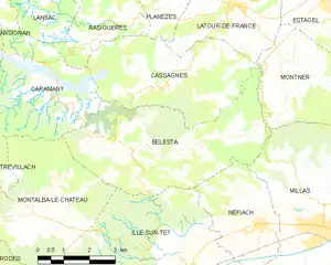
Map of Bélesta and its surrounding communes
Neighbouring communes
Places adjacent to Bélesta, Pyrénées-Orientales | |
|---|---|

Government and politics
- Mayors
| Mayor | Term start | Term end |
|---|---|---|
| Jacques Biles[2] | ? | June 1815 |
| Baptiste Pugnaud[2] | June 1815 | ? |
| Gilbert Bourniole | 2001 | 2007 |
| Roger Morin | 2007 | 2014 |
| Frédéric Bourniole | 2014 |
Population
| Year | Pop. | ±% |
|---|---|---|
| 1962 | 306 | — |
| 1968 | 312 | +2.0% |
| 1975 | 262 | −16.0% |
| 1982 | 247 | −5.7% |
| 1990 | 223 | −9.7% |
| 1999 | 215 | −3.6% |
| 2006 | 214 | −0.5% |
| 2009 | 219 | +2.3% |
Sites of interest
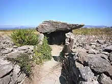
The Bélesta dolmen
- Prehistory museum
- Bélesta dolmen
- Bélesta cave
- Church of Saint Barthelemy in Bélesta
- Church of Saint Barthelemy in Jonqueroles
- Llébrès, an abandoned medieval hamlet
References
- "Populations légales 2017". INSEE. Retrieved 6 January 2020.
- Fabricio Cardenas, Vieux papiers des Pyrénées-Orientales, Bélesta, le 21 juin 1815, 31 january 2014
| Wikimedia Commons has media related to Bélesta (Pyrénées-Orientales). |
| Authority control |
|
|---|
This article is issued from Wikipedia. The text is licensed under Creative Commons - Attribution - Sharealike. Additional terms may apply for the media files.