Coustouges
Coustouges (Catalan: Costoja) is a commune in the Pyrénées-Orientales department in southern France. Inhabitants are called Coustougiens (male) or Coustougiennes (female).
Coustouges
Costoja | |
|---|---|
 A general view of Coustouges | |
Location of Coustouges 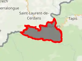
| |
 Coustouges  Coustouges | |
| Coordinates: 42°22′07″N 2°39′02″E | |
| Country | France |
| Region | Occitanie |
| Department | Pyrénées-Orientales |
| Arrondissement | Céret |
| Canton | Le Canigou |
| Intercommunality | Haut Vallespir |
| Government | |
| • Mayor (2014-2020) | Michel Anrigo |
| Area 1 | 16.86 km2 (6.51 sq mi) |
| Population (2017-01-01)[1] | 98 |
| • Density | 5.8/km2 (15/sq mi) |
| Time zone | UTC+01:00 (CET) |
| • Summer (DST) | UTC+02:00 (CEST) |
| INSEE/Postal code | 66061 /66260 |
| Elevation | 411–1,120 m (1,348–3,675 ft) (avg. 827 m or 2,713 ft) |
| 1 French Land Register data, which excludes lakes, ponds, glaciers > 1 km2 (0.386 sq mi or 247 acres) and river estuaries. | |
Geography
Localisation
Coustouges is located in the canton of Le Canigou and in the arrondissement of Céret.
Coustouges is the second most southerly commune of mainland France, after Lamanère. The village is situated at an altitude of 832 m.

Map of Coustouges and its surrounding communes
Neighbouring communes
Places adjacent to Coustouges | |
|---|---|

Toponymy
Coustouges was previously recorded with the name Costogia in 936, Custajas or Costogia, and finally Coustouges (end of the 19th century).
History
Coustouges was a dependency of the Abbey of Arles-sur-Tech from 988 until the French Revolution.
Population
| Year | Pop. | ±% p.a. |
|---|---|---|
| 1968 | 207 | — |
| 1975 | 171 | −2.69% |
| 1982 | 163 | −0.68% |
| 1990 | 119 | −3.86% |
| 1999 | 134 | +1.33% |
| 2007 | 116 | −1.79% |
| 2012 | 108 | −1.42% |
| 2017 | 98 | −1.92% |
| Source: INSEE[2] | ||
Notable people
- Francesc Sabaté Llopart (1915-1960), anarchist, anti-Francoist maquisard, spent several years in Coustouges
- François Pinault, French entrepreneur, bought a house there in September 2004.
Images
 Church of Notre-Dame de l’Aubépine
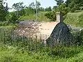 Tomb of an old family
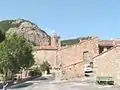 View of the church from the square
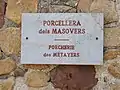 Typical street name plaque in Coustouges
References
- "Populations légales 2017". INSEE. Retrieved 6 January 2020.
- Population en historique depuis 1968, INSEE
External links
| Wikimedia Commons has media related to Coustouges. |
| Authority control |
|---|
This article is issued from Wikipedia. The text is licensed under Creative Commons - Attribution - Sharealike. Additional terms may apply for the media files.