Casteil
Casteil (Catalan: Castell de Vernet) is a commune in the Pyrénées-Orientales department in southern France, part of the historical Conflent comarca. The abbey Martin-du-Canigou is located above Casteil.
Casteil
Castell de Vernet | |
|---|---|
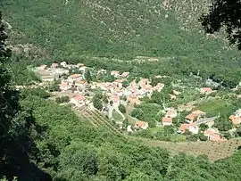 Casteil seen from the access road to the Abbey of Saint-Martin du Canigou | |
 Coat of arms | |
Location of Casteil 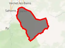
| |
 Casteil  Casteil | |
| Coordinates: 42°31′55″N 2°23′39″E | |
| Country | France |
| Region | Occitanie |
| Department | Pyrénées-Orientales |
| Arrondissement | Prades |
| Canton | Le Canigou |
| Intercommunality | Conflent |
| Government | |
| • Mayor (2014-2020) | Juliette Cases |
| Area 1 | 29.83 km2 (11.52 sq mi) |
| Population (2017-01-01)[1] | 136 |
| • Density | 4.6/km2 (12/sq mi) |
| Time zone | UTC+01:00 (CET) |
| • Summer (DST) | UTC+02:00 (CEST) |
| INSEE/Postal code | 66043 /66820 |
| Elevation | 697–2,721 m (2,287–8,927 ft) (avg. 750 m or 2,460 ft) |
| 1 French Land Register data, which excludes lakes, ponds, glaciers > 1 km2 (0.386 sq mi or 247 acres) and river estuaries. | |
Geography
Localisation
Casteil is located in the canton of Le Canigou and in the arrondissement of Prades.
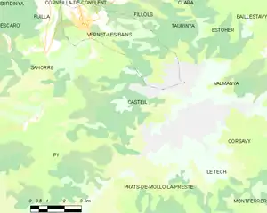
Map of Casteil and its surrounding communes
Neighbouring communes
Places adjacent to Casteil | |
|---|---|

Population
| Year | Pop. | ±% p.a. |
|---|---|---|
| 1968 | 59 | — |
| 1975 | 50 | −2.34% |
| 1982 | 52 | +0.56% |
| 1990 | 102 | +8.79% |
| 1999 | 130 | +2.73% |
| 2007 | 125 | −0.49% |
| 2012 | 129 | +0.63% |
| 2017 | 136 | +1.06% |
| Source: INSEE[2] | ||
References
- "Populations légales 2017". INSEE. Retrieved 6 January 2020.
- Population en historique depuis 1968, INSEE
| Wikimedia Commons has media related to Casteil. |
| Authority control |
|---|
This article is issued from Wikipedia. The text is licensed under Creative Commons - Attribution - Sharealike. Additional terms may apply for the media files.