Montalba-le-Château
Montalba-le-Château is a commune in the Pyrénées-Orientales department in southern France.
Montalba-le-Château
Montalban lo Castèl | |
|---|---|
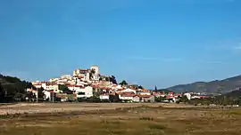 A general view of Montalba-le-Château | |
.svg.png.webp) Coat of arms | |
Location of Montalba-le-Château 
| |
 Montalba-le-Château  Montalba-le-Château | |
| Coordinates: 42°41′48″N 2°33′38″E | |
| Country | France |
| Region | Occitanie |
| Department | Pyrénées-Orientales |
| Arrondissement | Prades |
| Canton | La Vallée de la Têt |
| Intercommunality | Roussillon Conflent |
| Government | |
| • Mayor (2020–2026) | Marie Martinez |
| Area 1 | 15.9 km2 (6.1 sq mi) |
| Population (2017-01-01)[1] | 149 |
| • Density | 9.4/km2 (24/sq mi) |
| Time zone | UTC+01:00 (CET) |
| • Summer (DST) | UTC+02:00 (CEST) |
| INSEE/Postal code | 66111 /66130 |
| Elevation | 280–661 m (919–2,169 ft) (avg. 430 m or 1,410 ft) |
| 1 French Land Register data, which excludes lakes, ponds, glaciers > 1 km2 (0.386 sq mi or 247 acres) and river estuaries. | |
Geography
Localisation
Montalba-le-Château is located in the canton of La Vallée de la Têt and in the arrondissement of Prades.
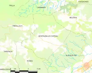
Map of Montalba-le-Château and its surrounding communes
Neighbouring communes
Places adjacent to Montalba-le-Château | |
|---|---|

Population
| Year | Pop. | ±% p.a. |
|---|---|---|
| 1968 | 203 | — |
| 1975 | 156 | −3.69% |
| 1982 | 121 | −3.56% |
| 1990 | 111 | −1.07% |
| 1999 | 120 | +0.87% |
| 2007 | 142 | +2.13% |
| 2012 | 148 | +0.83% |
| 2017 | 149 | +0.13% |
| Source: INSEE[2] | ||
References
- "Populations légales 2017". INSEE. Retrieved 6 January 2020.
- Population en historique depuis 1968, INSEE
| Wikimedia Commons has media related to Montalba-le-Château. |
| Authority control |
|---|
This article is issued from Wikipedia. The text is licensed under Creative Commons - Attribution - Sharealike. Additional terms may apply for the media files.