Sournia
Sournia (French pronunciation: [suʁnja] (![]() listen); Catalan: Sornià; Occitan: Sornhan) is a commune in the Pyrénées-Orientales department in the Occitanie region of south-western France. Its inhabitants are known as Sourniannais.
listen); Catalan: Sornià; Occitan: Sornhan) is a commune in the Pyrénées-Orientales department in the Occitanie region of south-western France. Its inhabitants are known as Sourniannais.
Sournia
Sornià Sornhan | |
|---|---|
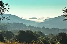 A general view of Sournia | |
2.svg.png.webp) Coat of arms | |
Location of Sournia 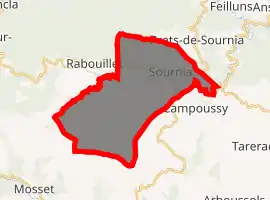
| |
 Sournia  Sournia | |
| Coordinates: 42°43′43″N 2°26′34″E | |
| Country | France |
| Region | Occitanie |
| Department | Pyrénées-Orientales |
| Arrondissement | Prades |
| Canton | La Vallée de l'Agly |
| Government | |
| • Mayor (2020–2026) | Yvon Crambes |
| Area 1 | 29.99 km2 (11.58 sq mi) |
| Population (2017-01-01)[1] | 498 |
| • Density | 17/km2 (43/sq mi) |
| Time zone | UTC+01:00 (CET) |
| • Summer (DST) | UTC+02:00 (CEST) |
| INSEE/Postal code | 66198 /66730 |
| Elevation | 380–1,234 m (1,247–4,049 ft) (avg. 500 m or 1,600 ft) |
| 1 French Land Register data, which excludes lakes, ponds, glaciers > 1 km2 (0.386 sq mi or 247 acres) and river estuaries. | |
Geography
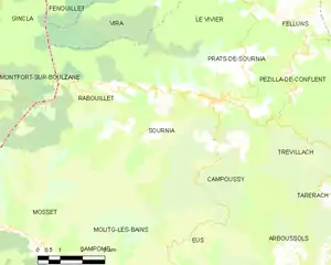
Sournia is a town of the Fenouillèdes, the languedocienne part of the Pyrénées-Orientales, in the canton of La Vallée de l'Agly and in the arrondissement of Prades. The river Désix runs through the village. Sournia is 22 km from Ille-sur-Têt and from Vinça, 24 km from Prades and from Saint-Paul-de-Fenouillet, 30 km from Latour-de-France and 34 km from Axat.
The commune is covered by the quality wine standard AOC 'Côtes-du-Roussillon'.
Sournia is crossed by the long distance footpath, GR 36.
Administration
The current mayor of Sournia is Paul Blanc, a senator, of the centre-right and right wing party UMP founded by Jacques Chirac.
Population
The population of Sournia in 2017 was 498 people. For some reason at the end of the 19th century, the population of Sournia seemed to have a reputation for having one of the longest longevity in France, even though this fact was not clearly verified.[2]
|
| ||||||||||||||||||||||||||||||||||||||||||||||||||||||||||||||||||||||||||||||||||||||||||||||||||||||||||||||||||
| Source: EHESS[3] and INSEE (1968-2017)[4] | |||||||||||||||||||||||||||||||||||||||||||||||||||||||||||||||||||||||||||||||||||||||||||||||||||||||||||||||||||
Places of interest
- Ruins of the former church of Saint-Michel from the tenth century.
- The ancient church of Sainte-Félicité from the tenth and eleventh centuries.
- Church of Arsa from the twelfth century.
References
- "Populations légales 2017". INSEE. Retrieved 6 January 2020.
- (in French) Fabricio Cardenas, Vieux papiers des Pyrénées-Orientales, Record de longévité à Sournia en 1897 , 3 January 2015
- Données Cassini, EHESS
- Population en historique depuis 1968, INSEE
| Wikimedia Commons has media related to Sournia. |
| Authority control |
|
|---|