Montauriol, Pyrénées-Orientales
Montauriol (French pronunciation: [mɔ̃toʁjɔl] (![]() listen); Catalan: Montoriol) is a commune in the Pyrénées-Orientales department in southern France.
listen); Catalan: Montoriol) is a commune in the Pyrénées-Orientales department in southern France.
Montauriol
Montoriol | |
|---|---|
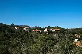 The village of Montauriol, seen from the church of Saint-Saturnin | |
Location of Montauriol 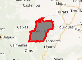
| |
 Montauriol  Montauriol | |
| Coordinates: 42°34′36″N 2°43′31″E | |
| Country | France |
| Region | Occitanie |
| Department | Pyrénées-Orientales |
| Arrondissement | Céret |
| Canton | Les Aspres |
| Intercommunality | Aspres |
| Government | |
| • Mayor (2020–2026) | Patrick Mauran[1] |
| Area 1 | 11.10 km2 (4.29 sq mi) |
| Population (2017-01-01)[2] | 247 |
| • Density | 22/km2 (58/sq mi) |
| Time zone | UTC+01:00 (CET) |
| • Summer (DST) | UTC+02:00 (CEST) |
| INSEE/Postal code | 66112 /66300 |
| Elevation | 149–463 m (489–1,519 ft) (avg. 244 m or 801 ft) |
| 1 French Land Register data, which excludes lakes, ponds, glaciers > 1 km2 (0.386 sq mi or 247 acres) and river estuaries. | |
Geography
Montauriol is located in the canton of Les Aspres and in the arrondissement of Céret.
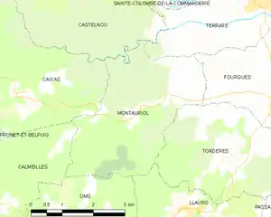
Map of Montauriol and its surrounding communes
Population
| Year | Pop. | ±% p.a. |
|---|---|---|
| 1968 | 78 | — |
| 1975 | 90 | +2.07% |
| 1982 | 125 | +4.80% |
| 1990 | 165 | +3.53% |
| 1999 | 188 | +1.46% |
| 2007 | 212 | +1.51% |
| 2012 | 208 | −0.38% |
| 2017 | 247 | +3.50% |
| Source: INSEE[3] | ||
References
- "Répertoire national des élus: les maires". data.gouv.fr, Plateforme ouverte des données publiques françaises (in French). 2 December 2020. Retrieved 7 December 2020.
- "Populations légales 2017". INSEE. Retrieved 6 January 2020.
- Population en historique depuis 1968, INSEE
| Wikimedia Commons has media related to Montauriol. |
| Authority control |
|---|
This article is issued from Wikipedia. The text is licensed under Creative Commons - Attribution - Sharealike. Additional terms may apply for the media files.