Rasiguères
Rasiguères is a commune in the Pyrénées-Orientales department in southern France.
Rasiguères
Rasiguèras | |
|---|---|
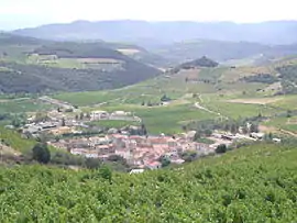 A general view of Rasiguères | |
.svg.png.webp) Coat of arms | |
Location of Rasiguères 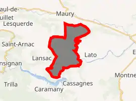
| |
 Rasiguères  Rasiguères | |
| Coordinates: 42°46′00″N 2°36′34″E | |
| Country | France |
| Region | Occitanie |
| Department | Pyrénées-Orientales |
| Arrondissement | Prades |
| Canton | La Vallée de l'Agly |
| Intercommunality | Agly Fenouillèdes |
| Government | |
| • Mayor (2008–2014) | Roger Chebille |
| Area 1 | 13.72 km2 (5.30 sq mi) |
| Population (2017-01-01)[1] | 152 |
| • Density | 11/km2 (29/sq mi) |
| Time zone | UTC+01:00 (CET) |
| • Summer (DST) | UTC+02:00 (CEST) |
| INSEE/Postal code | 66158 /66720 |
| Elevation | 104–548 m (341–1,798 ft) (avg. 182 m or 597 ft) |
| 1 French Land Register data, which excludes lakes, ponds, glaciers > 1 km2 (0.386 sq mi or 247 acres) and river estuaries. | |
Geography
Localisation
Rasiguères is in the canton of La Vallée de l'Agly and in the arrondissement of Perpignan.
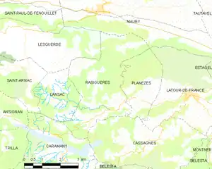
Map of Rasiguères and its surrounding communes
Neighbouring communes
Places adjacent to Rasiguères | |
|---|---|

Population
| Year | Pop. | ±% p.a. |
|---|---|---|
| 1968 | 228 | — |
| 1975 | 152 | −5.63% |
| 1982 | 162 | +0.91% |
| 1990 | 165 | +0.23% |
| 1999 | 168 | +0.20% |
| 2007 | 139 | −2.34% |
| 2012 | 167 | +3.74% |
| 2017 | 152 | −1.86% |
| Source: INSEE[2] | ||
Sites of interest
- A fortified tower from the 15th c. with remaining parts of ramparts.
- An old bridge from the 16th and 17th c. on the river Tournefort.
- The ruins of the Trémoine family castle with walls from the 13th c. and a tower from the 16th and 17th c.
- Ruins of the Castellas tower from the 12th and 13th c.
- The Saint John the Baptist Church from the 18th and 19th c.[3]
- Remains of an old church near the Tournefort bridge.
- Various old stone sheds in the vineyards.
References
- "Populations légales 2017". INSEE. Retrieved 6 January 2020.
- Population en historique depuis 1968, INSEE
- (in French) Fabricio Cardenas, Vieux papiers des Pyrénées-Orientales, Quête insistante du curé de Rasiguères en 1887 , 11 June 2015
| Wikimedia Commons has media related to Rasiguères. |
| Authority control |
|---|
This article is issued from Wikipedia. The text is licensed under Creative Commons - Attribution - Sharealike. Additional terms may apply for the media files.
