Saint-Arnac
Saint-Arnac (Occitan: Çantarnac) is a commune in the Pyrénées-Orientales department in southern France.
Saint-Arnac
Sent Arnac | |
|---|---|
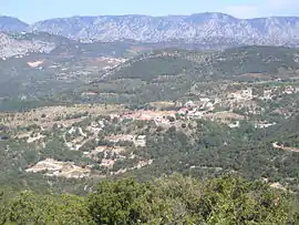 The village with the Corbières Massif in the background | |
 Coat of arms | |
Location of Saint-Arnac 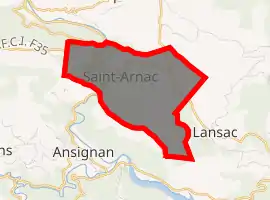
| |
 Saint-Arnac  Saint-Arnac | |
| Coordinates: 42°46′51″N 2°31′48″E | |
| Country | France |
| Region | Occitanie |
| Department | Pyrénées-Orientales |
| Arrondissement | Prades |
| Canton | La Vallée de l'Agly |
| Intercommunality | Agly Fenouillèdes |
| Government | |
| • Mayor (2008–2014) | Guy Calvet |
| Area 1 | 6.60 km2 (2.55 sq mi) |
| Population (2017-01-01)[1] | 115 |
| • Density | 17/km2 (45/sq mi) |
| Time zone | UTC+01:00 (CET) |
| • Summer (DST) | UTC+02:00 (CEST) |
| INSEE/Postal code | 66169 /66220 |
| Elevation | 212–583 m (696–1,913 ft) (avg. 306 m or 1,004 ft) |
| 1 French Land Register data, which excludes lakes, ponds, glaciers > 1 km2 (0.386 sq mi or 247 acres) and river estuaries. | |
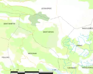
Geography
Saint-Arnac is in the canton of La Vallée de l'Agly and in the arrondissement of Perpignan.
Toponymy
- Attested forms
The name of Saint-Arnac appears in 899 as villare Centernacho, followed by Centernacum in the 12th century. But already in 1137, Ermengaud de So gives the name Sent Ernach, which later becomes Sant Arnach or Sanctum Arnachum, and then Saint-Arnac or Saint-Arnach in French.[2] · [3]
- Etymology
The original name, Centernach, is probably that of a landowner, followed by the suffix -acum, which may be either :[3]
- Centerinus (from Centenus) ;
- Cincturinus (from Cinctura) ;
- Centuriones (from centurion).
The mistake made in the 12th century by homonymy is a reference to a supposed saint Arnach, who never existed, although Arnac used to be a common German name at the time (from arn, eagle, followed by -acum).[3]
Population
| Year | Pop. | ±% p.a. |
|---|---|---|
| 1968 | 95 | — |
| 1975 | 67 | −4.87% |
| 1982 | 68 | +0.21% |
| 1990 | 65 | −0.56% |
| 1999 | 82 | +2.62% |
| 2007 | 120 | +4.87% |
| 2012 | 121 | +0.17% |
| 2017 | 115 | −1.01% |
| Source: INSEE[4] | ||
References
- "Populations légales 2017". INSEE. Retrieved 6 January 2020.
- (in French) Jean Sagnes (dir.), Le pays catalan, t. 2, Pau, Société nouvelle d'éditions régionales, 1985
- (in French) Lluís Basseda, Toponymie historique de Catalunya Nord, t. 1, Prades, Revista Terra Nostra, 1990
- Population en historique depuis 1968, INSEE
| Wikimedia Commons has media related to Saint-Arnac. |
| Authority control |
|---|