Espira-de-Conflent
Espira-de-Conflent (Catalan: Espirà de Conflent) is a commune in the Pyrénées-Orientales department in southern France.
Espira-de-Conflent
Espirà de Conflent | |
|---|---|
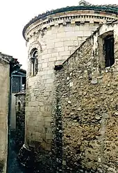 The church of Sainte-Marie, in Espira-de-Conflent | |
Location of Espira-de-Conflent 
| |
 Espira-de-Conflent  Espira-de-Conflent | |
| Coordinates: 42°37′05″N 2°29′56″E | |
| Country | France |
| Region | Occitanie |
| Department | Pyrénées-Orientales |
| Arrondissement | Prades |
| Canton | Le Canigou |
| Intercommunality | Conflent Canigó |
| Government | |
| • Mayor (2020–2026) | Roger Paillès |
| Area 1 | 6.03 km2 (2.33 sq mi) |
| Population (2017-01-01)[1] | 168 |
| • Density | 28/km2 (72/sq mi) |
| Time zone | UTC+01:00 (CET) |
| • Summer (DST) | UTC+02:00 (CEST) |
| INSEE/Postal code | 66070 /66320 |
| Elevation | 260–767 m (853–2,516 ft) (avg. 330 m or 1,080 ft) |
| 1 French Land Register data, which excludes lakes, ponds, glaciers > 1 km2 (0.386 sq mi or 247 acres) and river estuaries. | |
Geography
Localisation
Espira-de-Conflent is located in the canton of Le Canigou and in the arrondissement of Prades.
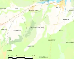
Map of Espira-de-Conflent and its surrounding communes
Neighbouring communes
Places adjacent to Espira-de-Conflent | |
|---|---|

Population
| Year | Pop. | ±% p.a. |
|---|---|---|
| 1968 | 162 | — |
| 1975 | 121 | −4.08% |
| 1982 | 124 | +0.35% |
| 1990 | 132 | +0.78% |
| 1999 | 125 | −0.60% |
| 2007 | 178 | +4.52% |
| 2012 | 169 | −1.03% |
| 2017 | 168 | −0.12% |
| Source: INSEE[2] | ||
References
- "Populations légales 2017". INSEE. Retrieved 6 January 2020.
- Population en historique depuis 1968, INSEE
| Wikimedia Commons has media related to Espira-de-Conflent. |
| Authority control |
|---|
This article is issued from Wikipedia. The text is licensed under Creative Commons - Attribution - Sharealike. Additional terms may apply for the media files.
