Urbanya
Urbanya (Catalan: Orbanyà) is a commune in the Pyrénées-Orientales department in southern France.
Urbanya
Orbanyà | |
|---|---|
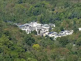 Urbanya at the bottom of the valley | |
Location of Urbanya 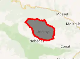
| |
 Urbanya  Urbanya | |
| Coordinates: 42°38′23″N 2°18′20″E | |
| Country | France |
| Region | Occitanie |
| Department | Pyrénées-Orientales |
| Arrondissement | Prades |
| Canton | Les Pyrénées catalanes |
| Government | |
| • Mayor (2008–2014) | Jean-Paul Sangla |
| Area 1 | 14.40 km2 (5.56 sq mi) |
| Population (2017-01-01)[1] | 55 |
| • Density | 3.8/km2 (9.9/sq mi) |
| Time zone | UTC+01:00 (CET) |
| • Summer (DST) | UTC+02:00 (CEST) |
| INSEE/Postal code | 66219 /66500 |
| Elevation | 720–1,765 m (2,362–5,791 ft) (avg. 400 m or 1,300 ft) |
| 1 French Land Register data, which excludes lakes, ponds, glaciers > 1 km2 (0.386 sq mi or 247 acres) and river estuaries. | |
Geography
Urbanya is located in the canton of Les Pyrénées catalanes and in the arrondissement of Prades.
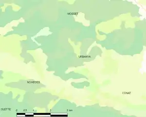
Map of Urbanya and its surrounding communes
History
Urbanya is mentioned for the first time on 16 June 1186, as being owned by the lord of Conat, on an act signed by Guillem-Bernard de Paracols, husband of Blanche de Conat.[2]
In September 1907, a rain and hailstorm falls on Urbanya, damaging and sometimes destroying the roads and bridges, as well with several houses.[3]
Population
| Year | Pop. | ±% p.a. |
|---|---|---|
| 1968 | 14 | — |
| 1975 | 28 | +10.41% |
| 1982 | 26 | −1.05% |
| 1990 | 33 | +3.02% |
| 1999 | 28 | −1.81% |
| 2007 | 57 | +9.29% |
| 2012 | 9 | −30.87% |
| 2017 | 55 | +43.62% |
| Source: INSEE[4] | ||
References
- "Populations légales 2017". INSEE. Retrieved 6 January 2020.
- (in French) Jean Sagnes (dir.), Le pays catalan, t. 2, Pau, Société nouvelle d'éditions régionales, 1985
- Cardenas, Fabricio (9 August 2014). "Déluge à Urbanya en 1907". Vieux papiers des Pyrénées-Orientales (in French). Retrieved 28 February 2016.
- Population en historique depuis 1968, INSEE
| Wikimedia Commons has media related to Urbanya. |
| Authority control |
|---|
This article is issued from Wikipedia. The text is licensed under Creative Commons - Attribution - Sharealike. Additional terms may apply for the media files.
