Armidale Regional Council
The Armidale Region is a local government area in the New England and Northern Tablelands regions of New South Wales, Australia. This area was formed in 2016 from the merger of the Armidale Dumaresq Shire with the surrounding Guyra Shire.[2]
| Armidale Region New South Wales | |||||||||||||||
|---|---|---|---|---|---|---|---|---|---|---|---|---|---|---|---|
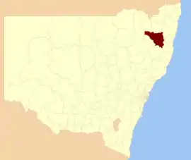 Location in New South Wales | |||||||||||||||
| Coordinates | 30°30′S 151°40′E | ||||||||||||||
| Population | 30,707 (2018)[1] | ||||||||||||||
| • Density | 3.56188/km2 (9.2252/sq mi) | ||||||||||||||
| Established | 2016 | ||||||||||||||
| Area | 8,621 km2 (3,328.6 sq mi)[1] | ||||||||||||||
| Mayor | Simon Murray (Independent) | ||||||||||||||
| Council seat | Armidale | ||||||||||||||
| Region | New England | ||||||||||||||
| State electorate(s) | Northern Tablelands | ||||||||||||||
| Federal Division(s) | New England | ||||||||||||||
| Website | Armidale Region | ||||||||||||||
| |||||||||||||||
The combined area covered the urban area of Armidale and the surrounding region, extending primarily eastward from the city through farming districts to the gorges and escarpments that mark the edge of the Northern Tablelands.
The Armidale Region is administered by the Armidale Regional Council.
The Mayor of the Armidale Region is Cr. Simon Murray, an independent politician.
History
On 1 July 2019, Tingha was transferred from Armidale Region to Inverell Shire.[3][4]
Main towns and villages
In addition to the main centre of Armidale and the town of Guyra, the villages located in the area include Ben Lomond, Black Mountain, Dangarsleigh, Ebor, Hillgrove, Kellys Plains, Llangothlin, and Wollomombi.
Heritage listings
The Armidale Region has a number of heritage-listed sites, including the following sites in Armidale:
- 158 Beardy Street: Armidale Post Office[5]
- 164 Beardy Street: Commercial Bank of Australia Building[6]
- 216 Brown Street: Armidale railway station turntable[7]
- 234 Brown Street: Armidale railway station[8]
- 125 Dangar Street: Central Park, Armidale[9]
- 132 Dangar Street: Saints Mary and Joseph Catholic Cathedral[10]
- 108 Faulkner Street: Lands Board Office[11]
- 60 Madgwick Drive: Booloominbah[12]
- 122-132 Mossman Street: Old Teachers' College[13]
- 36 Roseneath Lane: Roseneath[14]
- 122 Rusden Street: St Peter's Cathedral[15]
- 230 Saumarez Road: Saumarez Homestead[16]
- High Conservation Value Old Growth forest[17]
Demographics
| Selected historical census data for the Armidale Region | ||||||
|---|---|---|---|---|---|---|
| Census year | 2016[18] | |||||
| Population | Estimated residents on census night | 29,449 | ||||
| LGA rank in terms of size within New South Wales | 60th | |||||
| % of New South Wales population | 0.39% | |||||
| % of Australian population | 0.13% | |||||
| Cultural and language diversity | ||||||
| Ancestry, top responses | Australian | 30.4% | ||||
| English | 28.8% | |||||
| Irish | 9.8% | |||||
| Scottish | 8.4% | |||||
| German | 3.4% | |||||
| Language, top responses (other than English) | Mandarin | 1.1% | ||||
| Arabic | 1.0% | |||||
| Nepali | 0.5% | |||||
| German | 0.4% | |||||
| French | 0.2% | |||||
| Religious affiliation | ||||||
| Religious affiliation, top responses | No religion | 27.4% | ||||
| Anglican | 22.8% | |||||
| Catholic | 20.2% | |||||
| Presbyterian | 4.5% | |||||
| Median weekly incomes | ||||||
| Personal income | Median weekly personal income | A$561 | ||||
| % of Australian median income | 84.7% | |||||
| Family income | Median weekly family income | A$1465 | ||||
| % of Australian median income | 84.5% | |||||
| Household income | Median weekly household income | A$1173 | ||||
| % of Australian median income | 81.6% | |||||
Council
Armidale Regional Council is composed of eleven Councillors elected proportionally as a single ward. All Councillors are elected for a fixed four-year term of office. The Mayor is elected by the Councillors at the first meeting of the Council. The most recent election was held on 9 September 2017, and the makeup of the Council is as follows:[19]
| Party | Councillors | |
|---|---|---|
| Independents and Unaligned | 9 | |
| The Greens | 1 | |
| Country Labor Party | 1 | |
| Total | 11 | |
The current Council, elected in 2017, in order of election, is:[19]
| Councillor | Party | Notes | |
|---|---|---|---|
| Ian Tiley | Independent | ||
| Debra O'Brien | Country Labor Party | ||
| Simon Murray | Independent | Mayor[20] | |
| Margaret O'Connor | Independent | ||
| Jon Galletly | Independent | ||
| Dorothy Robinson | The Greens | ||
| Libby Martin | Independent | Deputy Mayor[20] | |
| Bradley Widders | Unaligned | ||
| Diane Gray | Independent | ||
| Andrew Murat | Independent | ||
| Peter Bailey | Independent | ||
References
- "3218.0 – Regional Population Growth, Australia, 2017-18: Population Estimates by Local Government Area (ASGS 2018), 2017 to 2018". Australian Bureau of Statistics. Australian Bureau of Statistics. 27 March 2019. Retrieved 25 October 2019. Estimated resident population, 30 June 2018.
- "Armidale Regional Council". www.strongercouncils.nsw.gov.au. Retrieved 22 November 2017.
- "It's official Tingha is on the move to Inverell". Armidale Regional Council. Armidale Regional Council. 8 February 2018. Retrieved 3 March 2019.
- "Tingha community joins Inverell Shire". Inverell Shire Council. 1 July 2019. Archived from the original on 13 August 2019. Retrieved 13 August 2019.
- "Armidale Post Office". New South Wales State Heritage Register. Office of Environment and Heritage. H01312. Retrieved 18 May 2018.
- "CBA Bank (former)". New South Wales State Heritage Register. Office of Environment and Heritage. H00433. Retrieved 18 May 2018.
- "Railway Turntable". New South Wales State Heritage Register. Office of Environment and Heritage. H01233. Retrieved 18 May 2018.
- "Armidale Railway Station and yard group movable relics". New South Wales State Heritage Register. Office of Environment and Heritage. H01075. Retrieved 18 May 2018.
- "Central Park". New South Wales State Heritage Register. Office of Environment and Heritage. H02019. Retrieved 18 February 2020.
- "St Mary & St Joseph Catholic Cathedral Group". New South Wales State Heritage Register. Office of Environment and Heritage. H01925. Retrieved 18 May 2018.
- "Lands Board Office". New South Wales State Heritage Register. Office of Environment and Heritage. H00963. Retrieved 18 May 2018.
- "Booloominbah". New South Wales State Heritage Register. Office of Environment and Heritage. H01768. Retrieved 18 May 2018.
- "C B Newling Centre". New South Wales State Heritage Register. Office of Environment and Heritage. H01769. Retrieved 18 May 2018.
- "Roseneath". New South Wales State Heritage Register. Office of Environment and Heritage. H00063. Retrieved 18 May 2018.
- "Anglican Cathedral Church of St Peter Apostle and Martyr Precinct". New South Wales State Heritage Register. Office of Environment and Heritage. H01924. Retrieved 18 May 2018.
- "Saumarez Homestead". New South Wales State Heritage Register. Office of Environment and Heritage. H01505. Retrieved 18 May 2018.
- "High Conservation Value Old Growth forest". New South Wales State Heritage Register. Office of Environment and Heritage. H01487. Retrieved 18 May 2018.
- Australian Bureau of Statistics (27 June 2017). "Armidale Regional (A)". 2016 Census QuickStats. Retrieved 7 July 2017.

- "Armidale Regional Council: Councillor Contest". Local Government Elections 2017. Electoral Commission of New South Wales. 16 September 2017. Retrieved 22 November 2017.
- Armidale Regional Council https://www.armidaleregional.nsw.gov.au/council/the-council-and-meetings/councillors. Retrieved 9 February 2020. Missing or empty
|title=(help)
External links
![]() Media related to Armidale Regional Council at Wikimedia Commons
Media related to Armidale Regional Council at Wikimedia Commons