Choctaw County, Oklahoma
Choctaw County is a county located in the U.S. state of Oklahoma. As of the 2010 census, the population was 15,205.[1] Its county seat is Hugo.[2]
Choctaw County | |
|---|---|
 The Choctaw County Courthouse in Hugo. | |
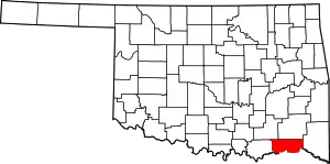 Location within the U.S. state of Oklahoma | |
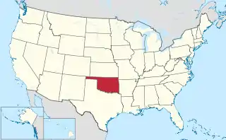 Oklahoma's location within the U.S. | |
| Coordinates: 34°02′N 95°33′W | |
| Country | |
| State | |
| Founded | 1907 |
| Seat | Hugo |
| Largest city | Hugo |
| Area | |
| • Total | 800 sq mi (2,000 km2) |
| • Land | 770 sq mi (2,000 km2) |
| • Water | 29 sq mi (80 km2) 3.7%% |
| Population | |
| • Estimate (2018) | 14,668 |
| • Density | 20/sq mi (8/km2) |
| Time zone | UTC−6 (Central) |
| • Summer (DST) | UTC−5 (CDT) |
| Congressional district | 2nd |
Formerly part of the Choctaw Nation in Indian Territory, this county was reorganized and redefined in 1907, at the time of Oklahoma statehood. According to the Encyclopedia of Oklahoma History and Culture, the name is derived from Chahta, the mythical founder of the Choctaw people.[3] It is part of the area of jurisdiction of the Choctaw Nation of Oklahoma.
History
The Choctaw Nation moved into the area now occupied by Choctaw County in 1831–1832, as a result of their forcible removal from their homeland in the Southeastern United States, under the Indian Removal Act. The US wanted to extinguish Native American land claims in the Southeast to enable development by European Americans. It offered land in exchange in Indian Territory.
The U.S. Army had already established Fort Towson in the western area in 1824, and took on the mission of protecting the newcomers from other tribes. In 1837, the Chickasaw were also removed, and settled the area around Doaksville, which was adjacent to the fort. Both the town of Fort Towson and Doaksville served as the capital of the Choctaw Nation. Doaksville became a ghost town after the Civil War. In 1848, the Presbyterian church established a mission, which still exists and is now known as Goodland Academy.[3]
The St. Louis and San Francisco Railway built a line through the town of Hugo in 1902, stimulating commercial development of the town as a regional center. Before statehood, the area of Choctaw County was part of Jackson, Kiamichi, Cedar, and Towson counties, Choctaw Nation. It included two of the three administrative super-regions comprising the Choctaw Nation: the Apukshunnubbee District and the Pushmataha District.[4] When Oklahoma became a state in 1907, Choctaw County was created and Hugo was named as the county seat.[3]
Recent events
In October 2011 the U.S. Navy announced plans to honor Choctaw County with the naming of a ship. The Joint High Speed Vessel (JHSV) will simultaneously honor the three American counties named Choctaw County, in the states of Alabama, Mississippi, and Oklahoma. "I grew up in Choctaw County, Miss., where people work hard to raise their families and provide for their children," Secretary of the Navy Ray Mabus said in announcing the plan. "I chose to name JHSV after Choctaw County to honor those men and women who represent rural America." USNS Choctaw County will bear hull number JHSV-2.[5]
Geography
.jpg.webp)

Choctaw County is in southeastern Oklahoma, in a 10-county area designated for tourism purposes by the Oklahoma Department of Tourism and Recreation as Choctaw Country.[6] According to the U.S. Census Bureau, the county has a total area of 800 square miles (2,100 km2), of which 770 square miles (2,000 km2) is land and 29 square miles (75 km2) (3.7%) is water.[7] The major streams in the county are the Kiamichi River, the Muddy Boggy River and the Clear Boggy River, which all drain into the Red River. Lakes include Hugo Lake, on the Kiamichi River, and Raymond Gary Lake.[3]
Major highways
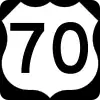 U.S. Highway 70
 U.S. Highway 271
 State Highway 93
 Indian Nation Turnpike
Adjacent counties
- Pushmataha County (north)
- McCurtain County (east)
- Red River County, Texas (southeast)
- Lamar County, Texas (south)
- Bryan County (west)
- Atoka County (northwest)
Demographics
| Historical population | |||
|---|---|---|---|
| Census | Pop. | %± | |
| 1910 | 21,862 | — | |
| 1920 | 32,144 | 47.0% | |
| 1930 | 24,142 | −24.9% | |
| 1940 | 28,358 | 17.5% | |
| 1950 | 20,405 | −28.0% | |
| 1960 | 15,637 | −23.4% | |
| 1970 | 15,141 | −3.2% | |
| 1980 | 17,203 | 13.6% | |
| 1990 | 15,302 | −11.1% | |
| 2000 | 15,342 | 0.3% | |
| 2010 | 15,205 | −0.9% | |
| 2018 (est.) | 14,668 | [8] | −3.5% |
| U.S. Decennial Census[9] 1790-1960[10] 1900-1990[11] 1990-2000[12] 2010-2013[1] | |||
As of the census[13] of 2000, there were 15,342 people, 6,220 households, and 4,285 families residing in the county. The population density was 20 people per square mile (8/km2). There were 7,539 housing units at an average density of 10 per square mile (4/km2). The racial makeup of the county was 68.55% White, 10.94% Black or African American, 14.96% Native American, 0.16% Asian, 0.02% Pacific Islander, 0.48% from other races, and 4.90% from two or more races. 1.60% of the population were Hispanic or Latino of any race. 97.1% spoke English, 1.6% Spanish and 1.3% Choctaw as their first language.
There were 6,220 households, out of which 30.00% had children under the age of 18 living with them, 51.30% were married couples living together, 14.40% had a female householder with no husband present, and 31.10% were non-families. 28.30% of all households were made up of individuals, and 14.90% had someone living alone who was 65 years of age or older. The average household size was 2.43 and the average family size was 2.96.
In the county, the population was spread out, with 26.00% under the age of 18, 7.80% from 18 to 24, 24.70% from 25 to 44, 24.10% from 45 to 64, and 17.40% who were 65 years of age or older. The median age was 39 years. For every 100 females there were 90.40 males. For every 100 females age 18 and over, there were 85.00 males. The median income for a household in the county was $22,743, and the median income for a family was $28,331. Males had a median income of $25,777 versus $18,805 for females. The per capita income for the county was $12,296. About 20.40% of families and 24.30% of the population were below the poverty line, including 32.50% of those under age 18 and 21.70% of those age 65 or over.
Life expectancy and health
Of 3,142 counties in the United States in 2014, the Institute for Health Metrics and Evaluation ranked Choctaw County 2,992 in the average life expectancy at birth of male residents and 3,081 in the life expectancy of female residents, among the lowest life expectancies of Oklahoma counties and among the lowest life expectancy for all counties. Males in Choctaw County lived an average of 70.8 years and females lived an average of 75.9 years compared to the national average for life expectancy of 76.7 for males and 81.5 for females.[14]
In the 1980-2014 period, the average life expectancy in Choctaw County for females declined by 0.8 years while male longevity increased by 3.7 years compared to the national average for the same period of an increased life expectancy of 4.0 years for women and 6.7 years for men. Choctaw County ranked in the worst performing 10 percent of all counties. High rates of smoking and obesity for both sexes and a low level of physical activity for males appear to be contributing factors to the relatively short life expectancy. [15]
In 2020, the Robert Wood Johnson Foundation ranked Choctaw country as last of 77 counties in Oklahoma in "health outcomes," as measured by length and quality of life.[16]
Politics
Despite the county being home to a significant Native American population and a wide Democratic registration advantage, the county -- like every Oklahoma county since 2000 -- has avoided the party entirely in presidential elections in the 21st century. Unlike other Native-administered counties, however, the rightward shift only increased after the 2004 election, with the GOP hitting well over 70% of the vote in the county in the Barack Obama era and topping out with 77.5% for Donald Trump in 2016.
| Voter Registration and Party Enrollment as of January 15, 2019[17] | |||||
|---|---|---|---|---|---|
| Party | Number of Voters | Percentage | |||
| Democratic | 5,053 | 59.14% | |||
| Republican | 2,376 | 27.81% | |||
| Others | 1,115 | 13.05% | |||
| Total | 8,544 | 100% | |||
| Year | Republican | Democratic | Third parties |
|---|---|---|---|
| 2020 | 80.6% 4,698 | 18.6% 1,082 | 0.8% 52 |
| 2016 | 77.5% 4,206 | 19.7% 1,067 | 2.8% 153 |
| 2012 | 70.5% 3,572 | 29.5% 1,494 | |
| 2008 | 66.7% 3,730 | 33.3% 1,860 | |
| 2004 | 54.6% 3,168 | 45.5% 2,639 | |
| 2000 | 46.3% 2,461 | 52.7% 2,799 | 1.0% 55 |
| 1996 | 29.4% 1,580 | 59.5% 3,198 | 11.2% 601 |
| 1992 | 25.7% 1,641 | 53.5% 3,413 | 20.7% 1,323 |
| 1988 | 39.6% 2,217 | 60.1% 3,362 | 0.4% 20 |
| 1984 | 52.7% 3,155 | 46.8% 2,801 | 0.5% 31 |
| 1980 | 39.8% 2,394 | 58.4% 3,507 | 1.8% 108 |
| 1976 | 29.7% 1,821 | 69.5% 4,269 | 0.8% 50 |
| 1972 | 64.4% 3,399 | 34.1% 1,798 | 1.5% 81 |
| 1968 | 26.0% 1,414 | 41.7% 2,268 | 32.2% 1,751 |
| 1964 | 30.2% 1,718 | 69.8% 3,969 | |
| 1960 | 46.3% 2,531 | 53.8% 2,941 | |
| 1956 | 38.9% 2,206 | 61.1% 3,469 | |
| 1952 | 34.6% 2,251 | 65.4% 4,260 | |
| 1948 | 17.9% 1,036 | 82.1% 4,750 | |
| 1944 | 24.3% 1,404 | 75.5% 4,358 | 0.2% 13 |
| 1940 | 31.3% 2,365 | 68.5% 5,177 | 0.3% 19 |
| 1936 | 21.5% 1,269 | 78.2% 4,624 | 0.3% 17 |
| 1932 | 17.5% 1,040 | 82.5% 4,908 | |
| 1928 | 49.3% 2,541 | 50.1% 2,581 | 0.6% 30 |
| 1924 | 38.1% 2,013 | 47.9% 2,528 | 14.0% 737 |
| 1920 | 42.7% 2,094 | 51.6% 2,531 | 5.8% 283 |
| 1916 | 27.1% 957 | 55.1% 1,945 | 17.8% 627 |
| 1912 | 24.6% 692 | 49.6% 1,392 | 25.8% 725 |
Economy
Agriculture, ranching and lumber have been the mainstays of the county economy since statehood. In 1910, cotton was the main crop. By 1930, the local agriculture industry had diversified to include corn, oats, prairie hay, and peanuts. At the start of the 21st century, soybeans, vegetables, and corn were the main crops. Retail businesses and health care were the largest employers.[3]
References
- "State & County QuickFacts". United States Census Bureau. Archived from the original on July 8, 2011. Retrieved November 8, 2013.
- "Find a County". National Association of Counties. Archived from the original on 2015-05-09. Retrieved 2011-06-07.
- Milligan, James C. "Choctaw County," Encyclopedia of Oklahoma History and Culture, 2009. Accessed March 28, 2015.
- Morris, John W. Historical Atlas of Oklahoma (Norman: University of Oklahoma Press, 1986), plate 38.
- Ronald O'Rourke, "Navy Ship Names: Background for Congress," pp. 5-6. October 7, 2011. Congressional Research Service. This report is quoting U.S. Department of Defense news release 859-11, "Navy Names New Joint High Speed Vessel," dated October 6, 2011, accessed on October 6, 2011 at http://www.defense.gov/releases/release.aspx?releaseid=14846.
- "Counties & Regions". Oklahoma Tourism and Recreation Department (Travel Promotion Division). Retrieved February 5, 2019.
- "2010 Census Gazetteer Files". United States Census Bureau. August 22, 2012. Retrieved February 18, 2015.
- "Population and Housing Unit Estimates". Retrieved December 26, 2019.
- "U.S. Decennial Census". United States Census Bureau. Retrieved February 18, 2015.
- "Historical Census Browser". University of Virginia Library. Retrieved February 18, 2015.
- Forstall, Richard L., ed. (March 27, 1995). "Population of Counties by Decennial Census: 1900 to 1990". United States Census Bureau. Retrieved February 18, 2015.
- "Census 2000 PHC-T-4. Ranking Tables for Counties: 1990 and 2000" (PDF). United States Census Bureau. April 2, 2001. Retrieved February 18, 2015.
- "U.S. Census website". United States Census Bureau. Retrieved 2008-01-31.
- "County Profiles: Choctaw County, Oklahoma" (PDF). Institute for Health Metrics and Evaluation. University of Washington. Retrieved 28 Dec 2020.
- "US Health Map". Institute of Health Metrics and Evaulation. University of Washington. Retrieved 28 December 2020.
- "2020 Oklahoma Report". Robert Wood Johnson Foundation. Retrieved 27 Dec 2020.
- "Oklahoma Registration Statistics by County" (PDF). OK.gov. January 15, 2019. Retrieved 2019-02-27.
- Leip, David. "Dave Leip's Atlas of U.S. Presidential Elections". uselectionatlas.org. Retrieved 2018-03-28.
External links
| Wikimedia Commons has media related to Choctaw County, Oklahoma. |
- Hugo and Choctaw County: Official Website
- Encyclopedia of Oklahoma History and Culture - Choctaw County
- Oklahoma Digital Maps: Digital Collections of Oklahoma and Indian Territory
Places adjacent to Choctaw County, Oklahoma | |
|---|---|
Municipalities and communities of Choctaw County, Oklahoma, United States | ||
|---|---|---|
| City | Choctaw County map | |
| Towns | ||
| CDPs | ||
| Other unincorporated communities | ||
| Indian reservation | ||
| Footnotes | ‡This populated place also has portions in another county or counties | |
| ||
Oklahoma City (capital) | ||
| Topics |
|  |
| Society |
| |
| Regions | ||
| Largest cities | ||
| Counties |
| |
| Authority control |
|---|