Texas County, Oklahoma
Texas County is a county located in the panhandle of the U.S. state of Oklahoma. Its county seat is Guymon. As of the 2010 census, the population was 20,640.[1] It is the second-largest county in the state, based on land area, and is named for Texas, the state that adjoins the county to its south.[2] Texas County comprises the Guymon, OK Micropolitan Statistical Area. The county economy is largely based on farming and cattle production. It is one of the top-producing counties in the U.S. for wheat, cattle, and hogs. It also lies within the noted Hugoton-Panhandle natural gas field.[2]
Texas County | |
|---|---|
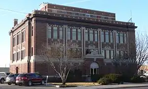 Texas County Courthouse in Guymon (2012) | |
 Location within the U.S. state of Oklahoma | |
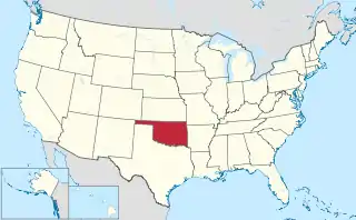 Oklahoma's location within the U.S. | |
| Coordinates: 36°45′N 101°29′W | |
| Country | |
| State | |
| Founded | 1907 |
| Named for | Texas |
| Seat | Guymon |
| Largest city | Guymon |
| Area | |
| • Total | 2,049 sq mi (5,310 km2) |
| • Land | 2,041 sq mi (5,290 km2) |
| • Water | 7.4 sq mi (19 km2) 0.4%% |
| Population (2010) | |
| • Total | 20,640 |
| • Estimate (2019) | 19,983 |
| • Density | 10/sq mi (4/km2) |
| Time zone | UTC−6 (Central) |
| • Summer (DST) | UTC−5 (CDT) |
| Congressional district | 3rd |
| Website | texas |
History
Texas County was formed at Oklahoma statehood (November 16, 1907) from the central one-third of "Old Beaver County". When the formation of the county was authorized by the Constitutional Convention of 1907, the county was so named because it was wholly included within the limits of the Texas Cession of 1850, whereby the ownership of the area was passed from the State of Texas to the United States government. From 1850 to 1890, its lands were never attached to any state or territory, never surveyed, and never divided into townships and sections like the eastern counties were. From 1890 to 1907, it was part of Beaver County.[2]
Geography
According to the U.S. Census Bureau, the county has a total area of 2,049 square miles (5,310 km2), of which 2,041 square miles (5,290 km2) are land and 7.4 square miles (19 km2) (0.4%) is water.[3] It is the second-largest county in Oklahoma by area. The county lies in the High Plains of the Great Plains physiographic region. It is generally flat, but has some rolling hills. It is drained by the North Canadian River, often called the Beaver River in this area. Tributaries of the river are Coldwater, Hackberry, Goff, Teepee, and Pony Creeks.[2]
For tourism purposes, the county's location in Northwest Oklahoma puts it in the area designated by the Oklahoma Department of Tourism as Red Carpet Country.[4]
The Optima Lake project, including Optima National Wildlife Refuge, and the Optima Wildlife Management Area being public hunting lands managed by the Oklahoma Department of Wildlife Conservation, is 2 miles (3.2 km) north of Hardesty, Oklahoma.[2]
Adjacent counties
- Stevens County, Kansas (north)
- Seward County, Kansas (northeast)
- Beaver County (east)
- Ochiltree County, Texas (southeast)
- Hansford County, Texas (south)
- Sherman County, Texas (southwest)
- Cimarron County (west)
- Morton County, Kansas (northwest)
Texas County is one of four counties in the United States to border the state with which it shares its name (the other three are Nevada County, California, Delaware County, Pennsylvania, and Ohio County, West Virginia).
National protected area
Demographics
| Historical population | |||
|---|---|---|---|
| Census | Pop. | %± | |
| 1910 | 14,249 | — | |
| 1920 | 13,975 | −1.9% | |
| 1930 | 14,100 | 0.9% | |
| 1940 | 9,896 | −29.8% | |
| 1950 | 14,235 | 43.8% | |
| 1960 | 14,162 | −0.5% | |
| 1970 | 16,352 | 15.5% | |
| 1980 | 17,727 | 8.4% | |
| 1990 | 16,419 | −7.4% | |
| 2000 | 20,107 | 22.5% | |
| 2010 | 20,640 | 2.7% | |
| 2019 (est.) | 19,983 | [5] | −3.2% |
| U.S. Decennial Census[6] 1790-1960[7] 1900-1990[8] 1990-2000[9] 2010-2019[1] | |||
As of the 2010 census, there were 20,640 people, 7,212 households, and 5,147 families residing in the county. The population density was 4/km2 (10/mi2). There were 8,208 housing units at an average density of 2/km2 (4/mi2). The racial makeup of the county was 75.7% White, 1.6% Black or African American, 1.3% Native American, 1.6% Asian, 0.2% Pacific Islander, 16.9% from other races, and 2.8% from two or more races. 42.0% of the population were Hispanic or Latino of any race (34.3% Mexican, 3.5% Guatemalan, 0.7% Cuban, 0.7% Spanish).[10][11] 65.7% spoke English and 33.1% Spanish as their first language.[12]
There were 7,153 households, out of which 39.00% had children under the age of 18 living with them, 61.50% were married couples living together, 7.50% had a female householder with no husband present, and 26.60% were non-families. 21.20% of all households were made up of individuals, and 8.20% had someone living alone who was 65 years of age or older. The average household size was 2.75 and the average family size was 3.19.
In the county, the population was spread out, with 28.80% under the age of 18, 12.70% from 18 to 24, 29.10% from 25 to 44, 19.20% from 45 to 64, and 10.20% who were 65 years of age or older. The median age was 30 years. For every 100 females there were 105.90 males. For every 100 females age 18 and over, there were 106.90 males.
The median income for a household in the county was $35,872, and the median income for a family was $42,226. Males had a median income of $26,991 versus $20,404 for females. The per capita income for the county was $15,692. About 10.20% of families and 14.10% of the population were below the poverty line, including 17.80% of those under age 18 and 7.40% of those age 65 or over.
Politics
Texas County has long been a Republican stronghold in presidential elections. The last Democrat to win the county was Harry Truman in 1948, with Republican candidates winning easily ever since. The Republican nominee for President has won at least 80% of the vote in each of the last six elections, dating back to 2000. Republicans also hold a very large voter registration edge in Texas County, as seen below. In the last few years, Democrats have achieved a very marginal increase, with the county being one of a handful where Hillary Clinton outperformed Barack Obama (in both 2008 and 2012). In 2020, Joe Biden received the highest percent for a Democrat in 20 years, though still lost in a landslide.
| Voter Registration and Party Enrollment as of January 15, 2019[13] | |||||
|---|---|---|---|---|---|
| Party | Number of Voters | Percentage | |||
| Democratic | 1,899 | 21.57% | |||
| Republican | 5,389 | 61.20% | |||
| Others | 1,517 | 17.23% | |||
| Total | 8,805 | 100% | |||
| Year | Republican | Democratic | Third parties |
|---|---|---|---|
| 2020 | 81.6% 4,505 | 16.2% 894 | 2.2% 122 |
| 2016 | 80.0% 4,621 | 14.8% 858 | 5.2% 301 |
| 2012 | 85.1% 4,930 | 14.9% 862 | |
| 2008 | 85.3% 5,336 | 14.8% 923 | |
| 2004 | 84.3% 5,450 | 15.7% 1,016 | |
| 2000 | 81.5% 4,964 | 17.8% 1,084 | 0.7% 40 |
| 1996 | 68.0% 4,139 | 23.1% 1,408 | 8.9% 544 |
| 1992 | 58.2% 4,059 | 21.3% 1,487 | 20.5% 1,434 |
| 1988 | 73.6% 4,971 | 25.4% 1,717 | 1.0% 64 |
| 1984 | 84.8% 5,968 | 14.7% 1,033 | 0.5% 38 |
| 1980 | 77.5% 5,503 | 20.4% 1,451 | 2.0% 145 |
| 1976 | 59.6% 3,919 | 39.4% 2,591 | 1.1% 70 |
| 1972 | 82.5% 5,726 | 13.3% 924 | 4.1% 287 |
| 1968 | 63.7% 3,729 | 20.1% 1,176 | 16.3% 954 |
| 1964 | 57.2% 3,339 | 42.8% 2,500 | |
| 1960 | 73.6% 4,314 | 26.4% 1,549 | |
| 1956 | 63.8% 3,320 | 36.2% 1,886 | |
| 1952 | 68.7% 4,196 | 31.3% 1,915 | |
| 1948 | 38.4% 1,676 | 61.6% 2,693 | |
| 1944 | 44.7% 1,731 | 54.8% 2,119 | 0.5% 20 |
| 1940 | 40.2% 1,918 | 59.3% 2,831 | 0.6% 28 |
| 1936 | 27.4% 1,223 | 72.2% 3,229 | 0.4% 19 |
| 1932 | 25.4% 1,372 | 74.6% 4,033 | |
| 1928 | 69.2% 2,890 | 29.7% 1,240 | 1.2% 49 |
| 1924 | 44.0% 1,745 | 45.7% 1,812 | 10.2% 405 |
| 1920 | 53.5% 1,762 | 42.4% 1,398 | 4.1% 135 |
| 1916 | 32.7% 807 | 54.6% 1,349 | 12.7% 313 |
| 1912 | 39.7% 683 | 44.4% 764 | 16.0% 275 |
Economy
Cattle raising was the most important economic activity before and after statehood. Farming rose in importance after the 1890s. Despite the occurrence of the Dust Bowl these two sectors have recovered and prospered. By 1990, Texas County led the state in producing grain sorghums, with 4.2 million bushels, or one-quarter of the state's harvest, and was the state's fourth-largest wheat-producing county, harvesting 10.3 million bushels. By 1997 it was the state's top producer of both hogs and cattle.[2]
Petroleum exploration began in 1922 and resulted in natural gas production from the Hugoton Gas Field. The county remains the nation's largest producer of natural gas. Four carbon black plants operated near Optima from the mid-1930s through the 1940s.[2] The field extends from Hugoton, Kansas into the Texas Panhandle.
The 2000 MW Windcatcher wind farm project, consisting of 800 wind turbines from GE and a high voltage AC power line, was proposed for Texas County and adjacent Cimarron County, but ran into opposition and was finally cancelled in July 2018.[15]
Education
The Oklahoma Legislature created the Pan-Handle Agricultural Institute in 1909, offering secondary agricultural education for the Panhandle area. In 1921, the legislature changed the name to Panhandle Agricultural and Mechanical College and authorized the school to offer a two-year curriculum. In 1925, the State Board of Agriculture authorized upper division college courses, and in 1926, junior and senior level courses were added. The school name has been changed twice since then, to Oklahoma Panhandle State College of Agriculture and Applied Science (OPSU) in 1967 and to Oklahoma Panhandle State University in 1974.[16] The school is in Goodwell.
Transportation
Major highways
 U.S. Highway 54
 U.S. Highway 56
 U.S. Highway 64
 U.S. Highway 412
 State Highway 3
 State Highway 94
 State Highway 95
 State Highway 136
Airports
Guymon Municipal Airport is a city-owned, public-use airport located two nautical miles (3.7 km) west of the central business district of City of Guymon in Texas County.
Communities
NRHP sites
The following are included among the twenty-four sites in Texas County listed on the National Register of Historic Places[18]
|
See also
References
- "State & County QuickFacts". United States Census Bureau. Retrieved November 13, 2013.
- Everett, Dianna."Texas County," Encyclopedia of Oklahoma History and Culture, Oklahoma Historical Society, 2009. Accessed April 5, 2015.
- "2010 Census Gazetteer Files". United States Census Bureau. August 22, 2012. Retrieved February 22, 2015.
- "Counties & Regions". Oklahoma Tourism and Recreation Department (Travel Promotion Division). Retrieved February 5, 2019.
- "County Population Totals: 2010-2019". Retrieved November 9, 2020.
- "U.S. Decennial Census". United States Census Bureau. Retrieved February 22, 2015.
- "Historical Census Browser". University of Virginia Library. Retrieved February 22, 2015.
- Forstall, Richard L., ed. (March 27, 1995). "Population of Counties by Decennial Census: 1900 to 1990". United States Census Bureau. Retrieved February 22, 2015.
- "Census 2000 PHC-T-4. Ranking Tables for Counties: 1990 and 2000" (PDF). United States Census Bureau. April 2, 2001. Retrieved February 22, 2015.
- Bureau, U.S. Census. "American FactFinder - Results". Archived from the original on May 21, 2019. Retrieved March 25, 2017.
- Bureau, U.S. Census. "American FactFinder - Results". Retrieved March 25, 2017.
- Bureau, U.S. Census. "American FactFinder - Results". Archived from the original on February 12, 2020. Retrieved March 25, 2017.
- "Oklahoma Registration Statistics by County" (PDF). OK.gov. January 15, 2019. Retrieved February 27, 2019.
- Leip, David. "Dave Leip's Atlas of U.S. Presidential Elections". uselectionatlas.org. Retrieved March 30, 2018.
- Bostian, Kelly (July 27, 2018). "'It feels good to breathe again': Local opponents respond to news of Wind Catcher project cancellation after failed Texas vote". Tulsa World. Retrieved September 26, 2019.
- Oklahoma Panhandle State University Retrieved February 16, 2014.
- 1910 Census
- "National Register Information System". National Register of Historic Places. National Park Service. July 9, 2010.
- "Iconic leaning elevator in Oklahoma panhandle is demolished". K. Querry, KFOR-TV, August 22, 2018. Retrieved January 5, 2021.
- "National Register of Historic Places Listings". Retrieved March 25, 2017.
External links
| Wikimedia Commons has media related to Texas County, Oklahoma. |
Places adjacent to Texas County, Oklahoma | |
|---|---|
Municipalities and communities of Texas County, Oklahoma, United States | ||
|---|---|---|
| Cities | Texas County map | |
| Towns | ||
| Unincorporated communities | ||
| ||
Oklahoma City (capital) | ||
| Topics |
|  |
| Society |
| |
| Regions | ||
| Largest cities | ||
| Counties |
| |
| Authority control |
|---|