National Register of Historic Places listings in Lincoln County, Kentucky
This is a list of the National Register of Historic Places listings in Lincoln County, Kentucky.
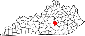
Location of Lincoln County in Kentucky
This is intended to be a complete list of the properties and districts on the National Register of Historic Places in Lincoln County, Kentucky, United States. The locations of National Register properties and districts for which the latitude and longitude coordinates are included below, may be seen in a map.[1]
There are 22 properties and districts listed on the National Register in the county.
- This National Park Service list is complete through NPS recent listings posted February 5, 2021.[2]
Current listings
| [3] | Name on the Register | Image | Date listed[4] | Location | City or town | Description |
|---|---|---|---|---|---|---|
| 1 | James W. Alcorn House | 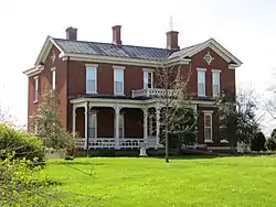 James W. Alcorn House |
April 22, 1980 (#80001649) |
409 Danville Ave. 37°31′58″N 84°40′09″W |
Stanford | |
| 2 | Arcadia | May 4, 1976 (#76000913) |
South of Shelby City on U.S. Route 127 37°33′37″N 84°47′21″W |
Shelby City | ||
| 3 | Baughman's Mill and Stanford Railroad Depot | 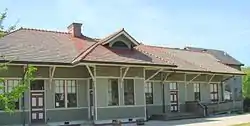 Baughman's Mill and Stanford Railroad Depot |
March 29, 1978 (#78001373) |
Depot and Mill Sts. 37°31′49″N 84°39′50″W |
Stanford | |
| 4 | John Baughman House | December 22, 1978 (#78001374) |
South of Stanford on Kentucky Route 1247 37°30′15″N 84°38′44″W |
Stanford | ||
| 5 | Samuel and Mary Logan Briggs House | 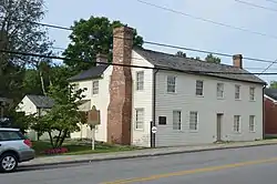 Samuel and Mary Logan Briggs House |
August 28, 1975 (#75000794) |
315 W. Main St. 37°31′44″N 84°39′52″W |
Stanford | |
| 6 | Confederate Monument at Crab Orchard | 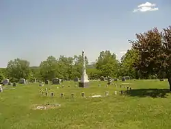 Confederate Monument at Crab Orchard |
July 17, 1997 (#97000682) |
Crab Orchard Cemetery, 0.5 miles east of the junction of Kentucky Routes 39 and 643 37°27′52″N 84°30′10″W |
Crab Orchard | |
| 7 | Helm-Engleman House | January 27, 1983 (#83002808) |
North of Hubble on Engleman Lane 37°36′55″N 84°39′46″W |
Hubble | ||
| 8 | Hoffman House | June 23, 1983 (#83002809) |
U.S. Route 27 37°34′47″N 84°36′25″W |
Lancaster | ||
| 9 | Nathan Huston House | June 23, 1983 (#83002810) |
Kentucky Route 78 37°28′22″N 84°49′23″W |
Hustonville | ||
| 10 | Lincoln County Courthouse | 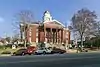 Lincoln County Courthouse |
April 22, 1976 (#76000915) |
Main and Lancaster Sts. 37°31′47″N 84°39′41″W |
Stanford | |
| 11 | John Logan House | 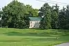 John Logan House |
June 11, 1975 (#75000795) |
East of Stanford at the junction of U.S. Route 150 and Goshen Rd. (Kentucky Route 642) 37°31′50″N 84°38′34″W |
Stanford | |
| 12 | McCormack Church | March 16, 1976 (#76000916) |
4 miles west of Stanford on Kentucky Route 1194 37°31′38″N 84°44′37″W |
Stanford | ||
| 13 | Abraham Miller House | March 6, 2001 (#00001083) |
3475 Kentucky Route 300 37°33′34″N 84°44′27″W |
Stanford | ||
| 14 | Dr. Thomas Montgomery House | 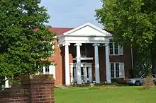 Dr. Thomas Montgomery House |
November 17, 1978 (#78001375) |
Somerset St. 37°31′18″N 84°39′44″W |
Stanford | |
| 15 | Adam Pence House | December 22, 1978 (#78001376) |
South of Stanford on Kentucky Route 1247 37°28′06″N 84°38′01″W |
Stanford | ||
| 16 | Richland Farm | August 4, 2004 (#04000792) |
5355 Kentucky Route 1194 37°31′07″N 84°47′01″W |
Stanford | ||
| 17 | Stanford Commercial District | 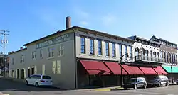 Stanford Commercial District |
November 17, 1986 (#86003173) |
Main St. from Somerset St. to 3rd St. 37°31′44″N 84°39′47″W |
Stanford | |
| 18 | Swope-Dudderar House and Mill Site | April 16, 1979 (#79001020) |
East of Stanford on Goshen Rd. 37°33′24″N 84°36′03″W |
Stanford | ||
| 19 | Traveler's Rest | May 3, 1976 (#76000914) |
South of Shelby City off Kentucky Route 300 37°33′51″N 84°47′02″W |
Shelby City | ||
| 20 | Walnut Meadows | December 22, 1978 (#78001377) |
Southeast of Stanford on U.S. Route 150 37°29′26″N 84°34′05″W |
Stanford | ||
| 21 | William Whitley House State Shrine | 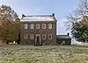 William Whitley House State Shrine |
April 11, 1973 (#73000814) |
2 miles west of Crab Orchard off U.S. Route 150 37°28′05″N 84°33′00″W |
Crab Orchard | |
| 22 | Horace Withers House | 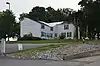 Horace Withers House |
December 30, 1987 (#87002189) |
Kentucky Route 590 (Hubble Rd.) 37°32′37″N 84°39′08″W |
Stanford |
See also
| Wikimedia Commons has media related to National Register of Historic Places in Lincoln County, Kentucky. |
References
- The latitude and longitude information provided in this table was derived originally from the National Register Information System, which has been found to be fairly accurate for about 99% of listings. Some locations in this table may have been corrected to current GPS standards.
- "National Register of Historic Places: Weekly List Actions". National Park Service, United States Department of the Interior. Retrieved on February 5, 2021.
- Numbers represent an alphabetical ordering by significant words. Various colorings, defined here, differentiate National Historic Landmarks and historic districts from other NRHP buildings, structures, sites or objects.
- The eight-digit number below each date is the number assigned to each location in the National Register Information System database, which can be viewed by clicking the number.
| Topics | |
|---|---|
| Lists by state |
|
| Lists by insular areas | |
| Lists by associated state | |
| Other areas | |
| Related | |
| |
Municipalities and communities of Lincoln County, Kentucky, United States | ||
|---|---|---|
| Cities | Location of Lincoln County, Kentucky | |
| CDP | ||
| Unincorporated communities | ||
| Footnotes | ‡This populated place also has portions in an adjacent county | |
| ||
This article is issued from Wikipedia. The text is licensed under Creative Commons - Attribution - Sharealike. Additional terms may apply for the media files.