National Register of Historic Places listings in Daggett County, Utah
This is a list of the National Register of Historic Places listings in Daggett County, Utah.
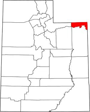
Location of Daggett County in Utah
This is intended to be a complete list of the properties and districts on the National Register of Historic Places in Daggett County, Utah, United States. Latitude and longitude coordinates are provided for many National Register properties and districts; these locations may be seen together in a map.[1]
There are 5 properties and districts listed on the National Register in the county.
- This National Park Service list is complete through NPS recent listings posted January 29, 2021.[2]
Current listings
| [3] | Name on the Register[4] | Image | Date listed[5] | Location | City or town | Description |
|---|---|---|---|---|---|---|
| 1 | Carter Road | May 21, 2001 (#00000354) |
Ashley National Forest 40°43′11″N 109°43′10″W |
Ashley National Forest | 1881-built military road in Daggett County and Uintah County | |
| 2 | John Jarvie Historic Ranch District | January 14, 1986 (#86000232) |
Green River and Indian Crossing Bridge east of Dutch John 40°54′03″N 109°10′32″W |
Browns Park | ||
| 3 | Manila Petroglyphs | October 6, 1975 (#75001802) |
Address Restricted[6] |
Manila | ||
| 4 | Dr. John Parsons Cabin Complex | November 21, 1976 (#76001812) |
Southwest of Bridgeport 40°51′49″N 109°08′42″W |
Bridgeport | ||
| 5 | Swett Ranch | 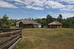 Swett Ranch |
July 10, 1979 (#79002492) |
Southwest of Dutch John 40°52′46″N 109°29′15″W |
Greendale | |
| 6 | Ute Mountain Fire Tower | 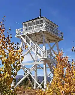 Ute Mountain Fire Tower |
April 10, 1980 (#80003895) |
Southwest of Manila 40°52′18″N 109°47′31″W |
Ashley National Forest |
See also
References
- The latitude and longitude information provided in this table was derived originally from the National Register Information System, which has been found to be fairly accurate for about 99% of listings. Some locations in this table may have been corrected to current GPS standards.
- "National Register of Historic Places: Weekly List Actions". National Park Service, United States Department of the Interior. Retrieved on January 29, 2021.
- Numbers represent an alphabetical ordering by significant words. Various colorings, defined here, differentiate National Historic Landmarks and historic districts from other NRHP buildings, structures, sites or objects.
- "National Register Information System". National Register of Historic Places. National Park Service. April 24, 2008.
- The eight-digit number below each date is the number assigned to each location in the National Register Information System database, which can be viewed by clicking the number.
- Some listings on the NRHP are highly sensitive sites and may be subject to looting or vandalism. The NRHP lists this site as "Address Restricted."
External links
![]() Media related to National Register of Historic Places in Daggett County, Utah at Wikimedia Commons
Media related to National Register of Historic Places in Daggett County, Utah at Wikimedia Commons
 | |||
| Topics | |
|---|---|
| Lists by state |
|
| Lists by insular areas | |
| Lists by associated state | |
| Other areas | |
| Related | |
| |
Municipalities and communities of Daggett County, Utah, United States | ||
|---|---|---|
| Town | Map of Utah highlighting Daggett County | |
| CDPs | ||
| Ghost towns | ||
| Footnotes | ‡This populated place also has portions in an adjacent state | |
| ||
This article is issued from Wikipedia. The text is licensed under Creative Commons - Attribution - Sharealike. Additional terms may apply for the media files.