National Register of Historic Places listings in Sevier County, Utah
This is a list of the National Register of Historic Places listings in Sevier County, Utah.

This is intended to be a complete list of the properties and districts on the National Register of Historic Places in Sevier County, Utah, United States. Latitude and longitude coordinates are provided for many National Register properties and districts; these locations may be seen together in a map.[1]
Sevier County and Sanpete County make up the "Little Scandinavia" portion of Utah, where many of Utah's 20,000 Scandinavian immigrants during the 19th century settled. Pair-houses, a Scandinavian home form, are relatively more common here than elsewhere in Utah.
There are 25 properties and districts listed on the National Register in the county. Another 4 sites in the county were once listed, but have since been removed.
- This National Park Service list is complete through NPS recent listings posted January 29, 2021.[2]
Current listings
| [3] | Name on the Register[4] | Image | Date listed[5] | Location | City or town | Description |
|---|---|---|---|---|---|---|
| 1 | Aspen-Cloud Rock Shelters | November 1, 1979 (#79002510) |
Address Restricted,[6] in Saleratus Canyon on Old Woman Plateau |
Salina | Archaic rock shelters that include archaeological remains of the earliest houses found in Utah. | |
| 2 | Elsinore Sugar Factory |  Elsinore Sugar Factory |
June 17, 1980 (#80003959) |
East of Elsinore 38°40′53″N 112°07′24″W |
Elsinore | |
| 3 | Elsinore White Rock Schoolhouse | 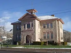 Elsinore White Rock Schoolhouse |
January 18, 1978 (#78002692) |
15 E. 200 North 38°41′10″N 112°08′50″W |
Elsinore | |
| 4 | Fish Lake Cut-off of the Old Spanish Trail Archeological District, Red Creek–Sheep Valley Segment | January 14, 2013 (#12001184) |
Address Restricted,[6] in Fishlake National Forest |
Salina vicinity | Designated by archaeological site code 42SV2828, the cut-off was part of an important interstate trade route about 1832–1853. | |
| 5 | Glenwood Cooperative Store | 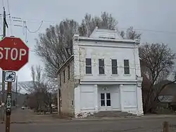 Glenwood Cooperative Store |
April 29, 1980 (#80003960) |
15 W. Center St. 38°45′47″N 111°59′23″W |
Glenwood | |
| 6 | Gooseberry Valley Archeological District | September 4, 1980 (#80003968) |
Address Restricted,[6] southeast of Salina in Fishlake National Forest |
Salina | Collection of archaeological sites left by the Fremont culture | |
| 7 | Jens Larson Jenson Lime Kiln | 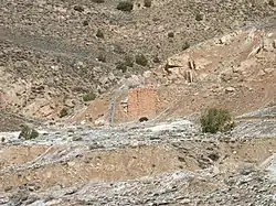 Jens Larson Jenson Lime Kiln |
December 22, 1978 (#78002693) |
2 miles (3.2 km) north of Richfield 38°47′36″N 112°05′08″W |
Richfield | |
| 8 | Martin Johnson House |  Martin Johnson House |
October 20, 1982 (#82001757) |
45 W. 400 South 38°45′27″N 111°59′25″W |
Glenwood | |
| 9 | Monroe City Hall |  Monroe City Hall |
April 1, 1985 (#85000814) |
55 N. Main St. 38°37′58″N 112°07′18″W |
Monroe | Spanish Colonial Revival building built in 1934, now the Monroe Public Library building. |
| 10 | Monroe Presbyterian Church | 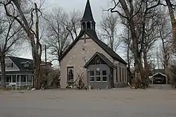 Monroe Presbyterian Church |
March 27, 1980 (#80003963) |
20 W. 100 North 38°38′02″N 112°07′16″W |
Monroe | |
| 11 | Old Spanish Trail Archeological District, Ivie Creek–Emigrant Pass Segment | January 14, 2013 (#12001185) |
Address Restricted,[6] in Fishlake National Forest |
Salina vicinity | ||
| 12 | Joseph William Parker Farm | 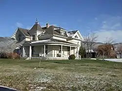 Joseph William Parker Farm |
March 25, 1977 (#77001318) |
2.5 miles (4.0 km) northeast of Joseph 38°39′18″N 112°11′39″W |
Joseph | |
| 13 | Peterson-Burr House | 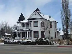 Peterson-Burr House |
February 18, 1994 (#94000037) |
190 W. Main 38°57′28″N 111°51′43″W |
Salina | |
| 14 | Redmond Hotel | 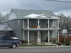 Redmond Hotel |
June 20, 1980 (#80003964) |
15 E. Main St. 39°00′22″N 111°51′48″W |
Redmond | |
| 15 | Redmond Town Hall |  Redmond Town Hall |
September 13, 1976 (#76001836) |
18 W. Main St. 39°00′22″N 111°51′50″W |
Redmond | |
| 16 | Richfield Carnegie Library | 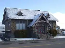 Richfield Carnegie Library |
October 25, 1984 (#84000153) |
83 E. Center St. 38°46′06″N 112°04′57″W |
Richfield | |
| 17 | Salina Hospital | 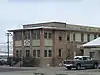 Salina Hospital |
June 19, 1980 (#80003966) |
330 W. Main St. 38°57′28″N 111°51′54″W |
Salina | |
| 18 | Salina Municipal Building and Library | 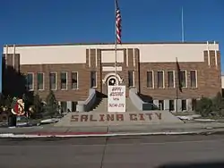 Salina Municipal Building and Library |
April 9, 1986 (#86000742) |
90 W. Main 38°57′28″N 111°51′38″W |
Salina | |
| 19 | Salina Presbyterian Church | 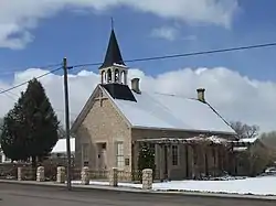 Salina Presbyterian Church |
March 27, 1980 (#80003967) |
204 S. 1st East 38°57′17″N 111°51′27″W |
Salina | |
| 20 | Sevier Ward Church | 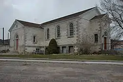 Sevier Ward Church |
June 24, 1980 (#80003969) |
East of Sevier along U.S. Route 89 38°35′43″N 112°14′58″W |
Sevier | |
| 21 | Soren Simonsen House | 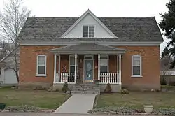 Soren Simonsen House |
October 20, 1982 (#82001758) |
55 W. 200 North 38°38′06″N 112°07′19″W |
Monroe | |
| 22 | Sudden Shelter (42SV6) | January 4, 1989 (#88003009) |
Address Restricted[6] |
Salina | A cave that has yielded projectile points from a range of archaeological periods | |
| 23 | US Post Office-Richfield Main | 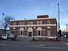 US Post Office-Richfield Main |
November 27, 1989 (#89001999) |
93 N. Main 38°46′09″N 112°05′04″W |
Richfield | |
| 24 | Joseph Wall Gristmill | 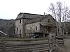 Joseph Wall Gristmill |
June 20, 1980 (#80003961) |
355 S. 250 East 38°45′30″N 111°59′05″W |
Glenwood | |
| 25 | Young Block | 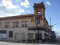 Young Block |
June 24, 1980 (#80003965) |
3-17 S. Main St. 38°46′04″N 112°05′01″W |
Richfield |
Former listings
| [3] | Name on the Register | Image | Date listed | Date removed | Location | City or town | Summary |
|---|---|---|---|---|---|---|---|
| 1 | Monroe Methodist Episcopal Church | May 23, 1980 (#80003962) | September 3, 2009 | 55 W 100 West |
Monroe | ||
| 2 | Ralph Ramsay House | July 8, 1975 (#75001824) | September 3, 2009 | 57 E. 200 North 38°46′16″N 112°04′59″W |
Richfield | Demolished in January 2008 [7] | |
| 3 | Richfield Tithing Office | January 25, 1985 (#85000284) | March 8, 1988 | 190 W. Center St. |
Richfield | ||
| 4 | Old Sevier County Courthouse | 1975 (#75002136) | 1976 | Main St. between 200 and 300 North |
Richfield |
See also
References
- The latitude and longitude information provided in this table was derived originally from the National Register Information System, which has been found to be fairly accurate for about 99% of listings. Some locations in this table may have been corrected to current GPS standards.
- "National Register of Historic Places: Weekly List Actions". National Park Service, United States Department of the Interior. Retrieved on January 29, 2021.
- Numbers represent an alphabetical ordering by significant words. Various colorings, defined here, differentiate National Historic Landmarks and historic districts from other NRHP buildings, structures, sites or objects.
- "National Register Information System". National Register of Historic Places. National Park Service. April 24, 2008.
- The eight-digit number below each date is the number assigned to each location in the National Register Information System database, which can be viewed by clicking the number.
- Some listings on the NRHP are highly sensitive sites and may be subject to looting or vandalism. The NRHP lists this site as "Address Restricted."
External links
![]() Media related to National Register of Historic Places in Sevier County, Utah at Wikimedia Commons
Media related to National Register of Historic Places in Sevier County, Utah at Wikimedia Commons
 | |||
| Topics | |
|---|---|
| Lists by state |
|
| Lists by insular areas | |
| Lists by associated state | |
| Other areas | |
| Related | |
| |
Municipalities and communities of Sevier County, Utah, United States | ||
|---|---|---|
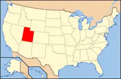
| Cities | Map of Utah highlighting Sevier County | |
| Towns | ||
| Unincorporated communities | ||
| Ghost town | ||
| Indian reservation | ||
| Footnotes | ‡This populated place also has portions in an adjacent county or counties | |
| ||
