National Register of Historic Places listings in Wasatch County, Utah
This is a list of the National Register of Historic Places listings in Wasatch County, Utah.
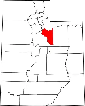
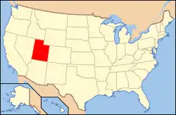
Location of Wasatch County in Utah
This is intended to be a complete list of the properties and districts on the National Register of Historic Places in Wasatch County, Utah, United States. Latitude and longitude coordinates are provided for many National Register properties and districts; these locations may be seen together in a map.[1]
There are 36 properties and districts listed on the National Register in the county. Another 3 properties were once listed on the Register but have been removed.
- This National Park Service list is complete through NPS recent listings posted January 29, 2021.[2]
Current listings
| [3] | Name on the Register[4] | Image | Date listed[5] | Location | City or town | Description |
|---|---|---|---|---|---|---|
| 1 | Austin–Wherritt House | 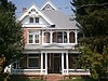 Austin–Wherritt House |
January 25, 1979 (#79002520) |
315 E. Center St. 40°30′28″N 111°24′25″W |
Heber City | |
| 2 | George Blackley House | 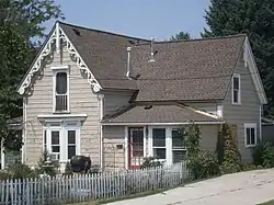 George Blackley House |
June 27, 1985 (#85001392) |
421 E. 200 North 40°30′38″N 111°24′19″W |
Heber City | |
| 3 | George Bonner Jr. House | 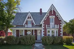 George Bonner Jr. House |
June 17, 1986 (#86001357) |
90 E. Main St. 40°30′43″N 111°28′11″W |
Midway | Designed and built by John Watkins |
| 4 | George Bonner Sr. House | 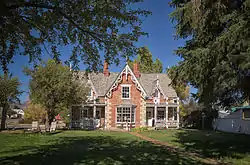 George Bonner Sr. House |
June 17, 1986 (#86001359) |
103 E. Main St. 40°30′44″N 111°28′09″W |
Midway | Designed and built by John Watkins |
| 5 | William Bonner House | 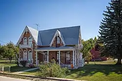 William Bonner House |
June 17, 1986 (#86001361) |
110 E. Main St. 40°30′43″N 111°28′09″W |
Midway | Designed by John Watkins |
| 6 | John H. and Agnes Buehler House |  John H. and Agnes Buehler House |
March 22, 2019 (#100003529) |
806 N. River Rd. 40°30′48″N 111°27′49″W |
Midway | |
| 7 | Burgener–Boss Farmstead | 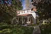 Burgener–Boss Farmstead |
May 26, 1994 (#94000534) |
102 W. 100 North 40°30′51″N 111°28′32″W |
Midway | |
| 8 | James William Clyde House |  James William Clyde House |
October 18, 1996 (#96001170) |
312 S. Main St. 40°30′12″N 111°24′47″W |
Heber City | |
| 9 | William Coleman House | 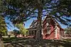 William Coleman House |
June 17, 1986 (#86001362) |
180 N. Center St. 40°30′57″N 111°28′16″W |
Midway | Designed by John Watkins |
| 10 | Heber and Matilda Crook House and Lake Creek Schoolhouse | 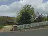 Heber and Matilda Crook House and Lake Creek Schoolhouse |
April 17, 1995 (#95000414) |
4800 E. Lake Creek Rd. 40°30′00″N 111°19′35″W |
Heber City | |
| 11 | John Crook House |  John Crook House |
November 16, 1978 (#78002705) |
188 W. 3rd North 40°30′43″N 111°24′57″W |
Heber City | |
| 12 | David Fisher House | 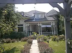 David Fisher House |
April 16, 1980 (#80003984) |
124 E. 400 South 40°30′08″N 111°24′38″W |
Heber City | |
| 13 | Levi and Ellen O'Neil Hancock House | 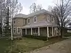 Levi and Ellen O'Neil Hancock House |
March 21, 2019 (#100003530) |
304 East 100 North 40°30′49″N 111°27′57″W |
Midway | |
| 14 | Abram Hatch House | 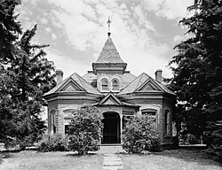 Abram Hatch House |
October 10, 1975 (#75001832) |
81 E. Center St. 40°30′28″N 111°24′42″W |
Heber City | |
| 15 | Heber Second Ward Meetinghouse |  Heber Second Ward Meetinghouse |
December 12, 1978 (#78002706) |
1st West and Center Sts. 40°30′26″N 111°24′51″W |
Heber City | |
| 16 | Lester F. and Margaret Stewart Hewlett Ranch House | May 23, 1985 (#85001134) |
Off State Route 35 40°34′45″N 111°07′34″W |
Woodland | ||
| 17 | John Huber House and Creamery | 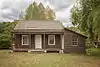 John Huber House and Creamery |
August 11, 1988 (#88001182) |
Off Snake Creek Canyon Rd. 40°32′31″N 111°29′53″W |
Midway | Part of Wasatch Mountain State Park |
| 18 | Midway Social Hall | 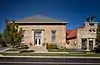 Midway Social Hall |
August 10, 1995 (#95000981) |
71 E. Main St. 40°30′45″N 111°28′13″W |
Midway | |
| 19 | Midway Town Hall | 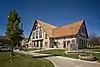 Midway Town Hall |
December 1, 1994 (#94001347) |
120 W. Main St. 40°30′45″N 111°28′48″W |
Midway | |
| 20 | John Murdoch House | 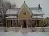 John Murdoch House |
February 28, 1980 (#80003985) |
261 N. 400 West 40°30′40″N 111°25′12″W |
Heber City | |
| 21 | Joseph S. Murdock House | 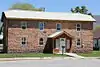 Joseph S. Murdock House |
May 1, 1987 (#87000701) |
115 E. 300 North 40°30′42″N 111°24′38″W |
Heber City | |
| 22 | Schneitter Hotel |  Schneitter Hotel |
December 17, 1992 (#92001691) |
700 N. Homestead Dr. 40°31′22″N 111°29′03″W |
Midway | |
| 23 | Snake Creek Hydroelectric Power Plant Historic District |  Snake Creek Hydroelectric Power Plant Historic District |
April 21, 1989 (#89000279) |
Snake Creek Canyon Rd. 40°33′20″N 111°31′12″W |
Midway | Part of Wasatch Mountain State Park |
| 24 | Stewart Ranch Foreman's House | May 23, 1985 (#85001135) |
Off State Route 35 40°33′28″N 111°08′06″W |
Woodland | ||
| 25 | Barnard J. Stewart Ranch House | May 23, 1985 (#85001136) |
Off State Route 35 40°34′00″N 111°07′57″W |
Woodland | ||
| 26 | Charles B. Stewart Ranch House | May 23, 1985 (#85001137) |
Off State Route 35 40°34′48″N 111°07′32″W |
Woodland | ||
| 27 | Samuel W. Stewart Ranch House | May 23, 1985 (#85001138) |
Off State Route 35 40°33′26″N 111°08′05″W |
Woodland | ||
| 28 | Stewart–Hewlett Ranch Dairy Barn | May 23, 1985 (#85001139) |
Off State Route 35 40°33′23″N 111°08′11″W |
Woodland | Dairy barn built in 1934 | |
| 29 | Wasatch Saloon |  Wasatch Saloon |
September 23, 1980 (#80003986) |
139 N. Main St. 40°30′34″N 111°24′47″W |
Heber City | |
| 30 | Wasatch Stake Tabernacle and Heber Amusement Hall | 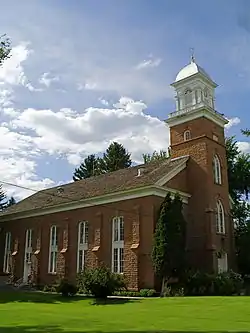 Wasatch Stake Tabernacle and Heber Amusement Hall |
December 2, 1970 (#70000633) |
Main St. at 100 North St. and 100 West St. corners 40°30′32″N 111°24′50″W |
Heber City | Wasatch Stake Tabernacle and Heber Amusement Hall |
| 31 | Wasatch Wave Publishing Company Building | 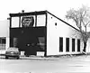 Wasatch Wave Publishing Company Building |
December 27, 1979 (#79002519) |
55 W. Center St. 40°30′26″N 111°24′44″W |
Heber City | Demolished in approximately 2000 |
| 32 | John and Margaret Watkins House | 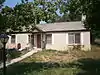 John and Margaret Watkins House |
June 17, 1986 (#86001364) |
22 W. 100 South 40°30′39″N 111°28′21″W |
Midway | Designed by John Watkins |
| 33 | Watkins-Coleman House | 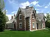 Watkins-Coleman House |
May 14, 1971 (#71000858) |
5 E. Main St. 40°30′45″N 111°28′16″W |
Midway | Designed and built by John Watkins |
| 34 | Ethelbert White and William M. Stewart Ranch House | May 23, 1985 (#85001140) |
Off State Route 35 40°33′29″N 111°08′05″W |
Woodland | ||
| 35 | Wilson House and Farmstead | 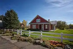 Wilson House and Farmstead |
July 3, 2007 (#07000667) |
94 E. 250 North 40°31′05″N 111°28′14″W |
Midway | |
| 36 | Attewall Wootton Jr House | 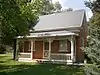 Attewall Wootton Jr House |
April 10, 1980 (#80003987) |
Approximately 285 E. Main St. 40°30′45″N 111°27′19″W |
Midway |
Former listings
| [3] | Name on the Register | Image | Date listed | Date removed | Location | City or town | Summary |
|---|---|---|---|---|---|---|---|
| 1 | Clotworthy–McMillan House | 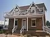 Clotworthy–McMillan House |
February 12, 1999 (#99000216) | March 26, 2018 | 261 S. Main St. 40°30′15″N 111°24′45″W |
Heber City | |
| 2 | Cloud Rim Girl Scout Lodge | April 9, 1986 (#86000751) | February 1, 1995 | Lake Brimhall 40°36′07″N 111°32′20″W |
Brighton vicinity | Destroyed by fire in November 1992, rebuilt in 1999 | |
| 3 | Midway School | March 29, 1978 (#78002707) | April 17, 1986 | First N and First W |
Midway |
See also
References
- The latitude and longitude information provided in this table was derived originally from the National Register Information System, which has been found to be fairly accurate for about 99% of listings. Some locations in this table may have been corrected to current GPS standards.
- "National Register of Historic Places: Weekly List Actions". National Park Service, United States Department of the Interior. Retrieved on January 29, 2021.
- Numbers represent an alphabetical ordering by significant words. Various colorings, defined here, differentiate National Historic Landmarks and historic districts from other NRHP buildings, structures, sites or objects.
- "National Register Information System". National Register of Historic Places. National Park Service. April 24, 2008.
- The eight-digit number below each date is the number assigned to each location in the National Register Information System database, which can be viewed by clicking the number.
External links
![]() Media related to National Register of Historic Places in Wasatch County, Utah at Wikimedia Commons
Media related to National Register of Historic Places in Wasatch County, Utah at Wikimedia Commons
 | |||
| Topics | |
|---|---|
| Lists by state |
|
| Lists by insular areas | |
| Lists by associated state | |
| Other areas | |
| Related | |
| |
Municipalities and communities of Wasatch County, Utah, United States | ||
|---|---|---|
| Cities | Map of Utah highlighting Wasatch County | |
| Towns | ||
| CDP | ||
| Unincorporated community | ||
| Indian reservation | ||
| Ghost towns | ||
| Footnotes | ‡This populated place also has portions in an adjacent county or counties | |
| ||
This article is issued from Wikipedia. The text is licensed under Creative Commons - Attribution - Sharealike. Additional terms may apply for the media files.