National Register of Historic Places listings in Kane County, Utah
This is a list of the National Register of Historic Places listings in Kane County, Utah.
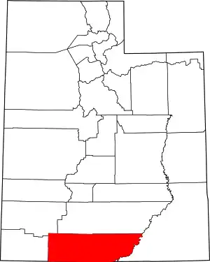
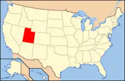
Location of Kane County in Utah
This is intended to be a complete list of the properties and districts on the National Register of Historic Places in Kane County, Utah, United States. Latitude and longitude coordinates are provided for many National Register properties and districts; these locations may be seen together in a map.[1]
There are 19 properties listed on the National Register in the county.
- This National Park Service list is complete through NPS recent listings posted January 29, 2021.[2]
Current listings
| [3] | Name on the Register[4] | Image | Date listed[5] | Location | City or town | Description |
|---|---|---|---|---|---|---|
| 1 | Bowman-Chamberlain House | .jpg.webp) Bowman-Chamberlain House |
July 8, 1975 (#75001811) |
14 East 100 South 37°02′47″N 112°31′37″W |
Kanab | |
| 2 | Cottonwood Canyon Cliff Dwelling | August 18, 1980 (#80003910) |
Address Restricted[6] |
Kanab | ||
| 3 | Davis Gulch Pictograph Panel | June 5, 1975 (#75000166) |
Address Restricted[6] |
Glen Canyon | ||
| 4 | East Entrance Checking Station | 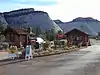 East Entrance Checking Station |
February 14, 1987 (#86003711) |
Island in middle of State Route 9 37°14′01″N 112°52′06″W |
Zion National Park | Also included in National Register of Historic Places listings in Zion National Park |
| 5 | East Entrance Residence | 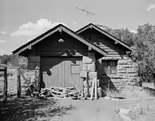 East Entrance Residence |
February 14, 1987 (#86003712) |
Eastern entrance 150 feet north of State Route 9 37°14′01″N 112°52′41″W |
Zion National Park | Also included in National Register of Historic Places listings in Zion National Park |
| 6 | East Entrance Sign | 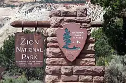 East Entrance Sign |
July 7, 1987 (#86003710) |
East Entrance Checking Station on northern and southern sides of State Route 9 37°14′07″N 112°52′07″W |
Zion National Park | Also included in National Register of Historic Places listings in Zion National Park |
| 7 | Maynard and Edith Hamlin Dixon House and Studio | 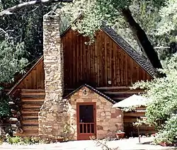 Maynard and Edith Hamlin Dixon House and Studio |
January 11, 2002 (#01001450) |
U.S. Route 89 37°15′13″N 112°39′37″W |
Orderville | |
| 8 | Hole-In-The-Rock |  Hole-In-The-Rock |
November 3, 1975 (#75000165) |
Southeast of Escalante in Glen Canyon National Recreation Area 37°15′31″N 110°54′00″W |
Escalante | |
| 9 | Hole-in-the-Rock Trail |  Hole-in-the-Rock Trail |
August 9, 1982 (#82004792) |
A trail commencing at Escalante and terminating at Bluff 37°25′18″N 110°39′51″W |
Escalante | Split between Garfield, Kane, and San Juan counties |
| 10 | William Derby Johnson, Jr., House | .jpg.webp) William Derby Johnson, Jr., House |
April 6, 2001 (#01000315) |
54 South Main Street 37°02′49″N 112°31′42″W |
Kanab | The Purple Sage Inn Bed and Breakfast is here in 2013. |
| 11 | Kanab (Union Pacific) Lodge | .jpg.webp) Kanab (Union Pacific) Lodge |
August 14, 2003 (#03000153) |
86 South 200 West 37°02′48″N 112°31′57″W |
Kanab | Former home of the Wok Inn, the building seemed deserted in 2013. |
| 12 | Kanab Hotel and Cafe |  Kanab Hotel and Cafe |
August 14, 2003 (#03000152) |
19 West Center Street 37°02′52″N 112°31′42″W |
Kanab | |
| 13 | Kanab Library | 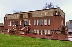 Kanab Library |
September 7, 1995 (#95001067) |
6 South 100 East 37°02′53″N 112°31′33″W |
Kanab | |
| 14 | Kanab Post Office |  Kanab Post Office |
January 24, 2011 (#10001175) |
22 North Main Street 37°02′55″N 112°31′43″W |
Kanab | Kanab, Utah MPS |
| 15 | Mt. Carmel School and Church | 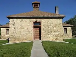 Mt. Carmel School and Church |
November 20, 1987 (#87002061) |
Off U.S. Route 89 37°14′48″N 112°39′55″W |
Orderville | |
| 16 | Parry Lodge | .jpg.webp) Parry Lodge |
August 14, 2003 (#02001734) |
89 East Center Street 37°02′54″N 112°31′34″W |
Kanab | |
| 17 | Paso por Aqui-Anno 1776 Inscription | August 17, 2018 (#100002785) |
Address Restricted |
Big Water vicinity | ||
| 18 | Rainbow Point Comfort Station and Overlook Shelter | 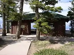 Rainbow Point Comfort Station and Overlook Shelter |
April 25, 1995 (#95000427) |
Bryce Canyon National Park 37°28′31″N 112°14′21″W |
Bryce Canyon National Park | |
| 19 | Rider-Pugh House | .jpg.webp) Rider-Pugh House |
April 6, 2001 (#01000316) |
17 West 100 South 37°02′49″N 112°31′42″W |
Kanab | |
| 20 | Riggs Spring Fire Trail | April 25, 1995 (#95000431) |
Bryce Canyon National Park 37°27′47″N 112°14′15″W |
Bryce Canyon National Park | ||
| 21 | Stewart-Woolley House | .jpg.webp) Stewart-Woolley House |
April 6, 2001 (#01000314) |
106 West 100 North 37°03′00″N 112°31′49″W |
Kanab | |
| 22 | Valley School | April 1, 1985 (#85000807) |
150 North Main Street 37°16′45″N 112°38′18″W |
Orderville | ||
| 23 | Zion – Mount Carmel Highway | 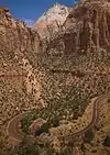 Zion – Mount Carmel Highway |
July 7, 1987 (#86003709) |
Along Utah State Route 9 between Springdale and Mount Carmel Junction 37°13′19″N 112°55′58″W |
Zion National Park (primarily) |
Also included in National Register of Historic Places listings in Washington County, Utah and National Register of Historic Places listings in Zion National Park |
See also
References
- The latitude and longitude information provided in this table was derived originally from the National Register Information System, which has been found to be fairly accurate for about 99% of listings. Some locations in this table may have been corrected to current GPS standards.
- "National Register of Historic Places: Weekly List Actions". National Park Service, United States Department of the Interior. Retrieved on January 29, 2021.
- Numbers represent an alphabetical ordering by significant words. Various colorings, defined here, differentiate National Historic Landmarks and historic districts from other NRHP buildings, structures, sites or objects.
- "National Register Information System". National Register of Historic Places. National Park Service. April 24, 2008.
- The eight-digit number below each date is the number assigned to each location in the National Register Information System database, which can be viewed by clicking the number.
- Some listings on the NRHP are highly sensitive sites and may be subject to looting or vandalism. The NRHP lists this site as "Address Restricted."
External links
![]() Media related to National Register of Historic Places in Kane County, Utah at Wikimedia Commons
Media related to National Register of Historic Places in Kane County, Utah at Wikimedia Commons
 | |||
| Topics | |
|---|---|
| Lists by state |
|
| Lists by insular areas | |
| Lists by associated state | |
| Other areas | |
| Related | |
| |
Municipalities and communities of Kane County, Utah, United States | ||
|---|---|---|
| City | Map of Utah highlighting Kane County | |
| Towns | ||
| Unincorporated communities | ||
| Ghost towns | ||
| ||
This article is issued from Wikipedia. The text is licensed under Creative Commons - Attribution - Sharealike. Additional terms may apply for the media files.