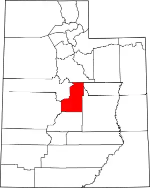
National Register of Historic Places listings in Sanpete County, Utah
This is a list of the National Register of Historic Places listings in Sanpete County, Utah.
This is intended to be a complete list of the properties and districts on the National Register of Historic Places in Sanpete County, Utah, United States. Latitude and longitude coordinates are provided for many National Register properties and districts; these locations may be seen together in a map.[1]
Sanpete County and Sevier County make up the "Little Scandinavia" portion of Utah, where many of Utah's 20,000 Scandinavian immigrants during the 19th century settled. Pair-houses, a Scandinavian home form, are relatively common.
There are 81 properties and districts listed on the National Register in the county. One other site in the county was once listed, but has since been removed.
- This National Park Service list is complete through NPS recent listings posted February 5, 2021.[2]
Current listings
| [3] | Name on the Register[4] | Image | Date listed[5] | Location | City or town | Description |
|---|---|---|---|---|---|---|
| 1 | Claus P. Andersen House | 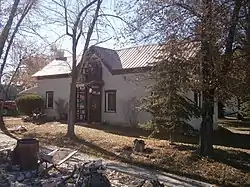 Claus P. Andersen House |
February 1, 1983 (#83003183) |
202 S. 200 East 39°21′22″N 111°34′56″W |
Ephraim | Adobe Scandinavian-style pair-house, one of oldest structures in Ephraim. |
| 2 | Lars S. Andersen House |  Lars S. Andersen House |
February 1, 1983 (#83003184) |
213 N. 200 East 39°21′50″N 111°34′56″W |
Ephraim | Pair house with additions. |
| 3 | James Anderson House |  James Anderson House |
October 3, 1980 (#80003945) |
15 S. 200 East 39°37′40″N 111°26′03″W |
Fairview | |
| 4 | Lewis and Clara Anderson House |  Lewis and Clara Anderson House |
January 12, 1998 (#97001629) |
542 S. Main St. 39°15′27″N 111°38′15″W |
Manti | Two-story brick Queen Anne. |
| 5 | Niels Ole Anderson House | 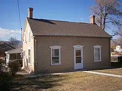 Niels Ole Anderson House |
October 5, 1978 (#78002687) |
308 S. 100 East 39°21′15″N 111°35′04″W |
Ephraim | Built in 1868 with Greek Revival and Federal stylings. |
| 6 | Ole Arilsen House | 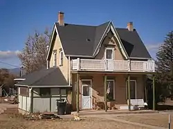 Ole Arilsen House |
October 3, 1980 (#80003953) |
89 N. 300 East 39°32′52″N 111°27′00″W |
Mount Pleasant | Folk vernacular house of "2/3 central passageway plan" type, "with excellent brickwork". |
| 7 | Andrew Barentsen House | February 1, 1983 (#83003185) |
195 W. 200 South 39°37′28″N 111°38′22″W |
Fountain Green | Three-room pair house, possibly demolished sometime between 2007 & 2018. | |
| 8 | Anthony W. Bessey House | 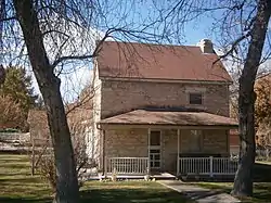 Anthony W. Bessey House |
October 22, 1980 (#80003947) |
415 N. 300 West 39°16′18″N 111°38′34″W |
Manti | Small stone house built around 1860, one of first outside Manti's forts. |
| 9 | Billings-Hougaard House | October 14, 1980 (#80003948) |
75 E. 300 North 39°16′12″N 111°38′07″W |
Manti | One of best surviving unsheathed adobe brick homes in Utah. | |
| 10 | W.D. Candland House | 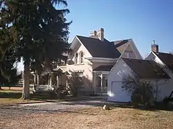 W.D. Candland House |
September 30, 2019 (#100004482) |
123 North 100 West 39°32′55″N 111°27′28″W |
Mount Pleasant | Two-story brick Victorian Eclectic house built in 1904. |
| 11 | Casino Theatre |  Casino Theatre |
September 22, 1989 (#89001416) |
78 S. Main St. 39°09′15″N 111°49′04″W |
Gunnison | |
| 12 | Centerfield School and Meetinghouse |  Centerfield School and Meetinghouse |
September 12, 2000 (#00001068) |
140 S. Main St. 39°07′25″N 111°49′11″W |
Centerfield | Stone school and church from c. 1886-67. |
| 13 | Cox Family Big House Complex | April 7, 2020 (#100005176) |
98 North 100 West 39°16′02″N 111°38′20″W |
Manti | ||
| 14 | Cox-Shoemaker-Parry House | 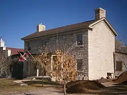 Cox-Shoemaker-Parry House |
August 4, 1982 (#82004157) |
50 N. 100 West 39°15′59″N 111°38′19″W |
Manti | Limestone house built in 1858 by Cox, where he lived with his three wives. Expanded by Parry in 1880. |
| 15 | Charles Crawforth Farmstead |  Charles Crawforth Farmstead |
February 19, 1980 (#80003956) |
Southwest of Spring City, approximately 6700 Crawford Rd. 39°27′16″N 111°30′45″W |
Spring City | 1884 stone house and outbuildings, relatively isolated |
| 16 | John Dorius, Jr., House | 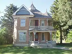 John Dorius, Jr., House |
May 9, 1985 (#85000964) |
46 W. 100 North 39°21′43″N 111°35′18″W |
Ephraim | Brick Queen Anne house from 1897. |
| 17 | Ephraim Carnegie Library | 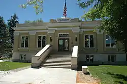 Ephraim Carnegie Library |
October 25, 1984 (#84000149) |
30 S. Main St. 39°22′05″N 111°35′12″W |
Ephraim | |
| 18 | Ephraim Relief Society Granary | 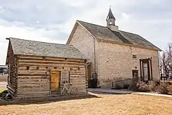 Ephraim Relief Society Granary |
September 30, 2019 (#100004481) |
86 N. Main St. 39°21′40″N 111°35′12″W |
Ephraim | Two-story stone granary building right on Main St., recently home of "Granary Arts" |
| 19 | Ephraim Tithing Office—Bishop's Storehouse | October 30, 2020 (#85003671) |
64 N. Main 39°21′31″N 111°35′14″W |
Ephraim | ||
| 20 | Ephraim United Order Cooperative Building | 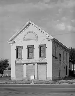 Ephraim United Order Cooperative Building |
March 20, 1973 (#73001862) |
Main and 1st North Sts. 39°21′41″N 111°35′09″W |
Ephraim | |
| 21 | Fairview Amusement Hall |  Fairview Amusement Hall |
May 10, 2002 (#02000507) |
75 S. State St. 39°37′38″N 111°26′18″W |
Fairview | |
| 22 | Fairview City Hall |  Fairview City Hall |
April 9, 1986 (#86000745) |
85 S. State St. 39°37′36″N 111°26′18″W |
Fairview | |
| 23 | Fairview Tithing Office/Bishop's Storehouse | 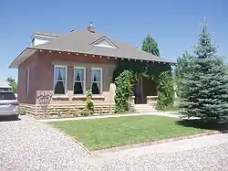 Fairview Tithing Office/Bishop's Storehouse |
January 25, 1985 (#85000281) |
60 W. 100 South 39°37′36″N 111°26′23″W |
Fairview | |
| 24 | Jabez Faux House and Barn |  Jabez Faux House and Barn |
November 7, 1976 (#76001835) |
Approximately 74 N. State Route 132 39°31′35″N 111°35′24″W |
Moroni | Home of blacksmith and farmer immigrant from Yorkshire. |
| 25 | Fountain Green Hydroelectric Plant Historic District |  Fountain Green Hydroelectric Plant Historic District |
April 20, 1989 (#89000277) |
Northwest of Fountain Green 39°38′13″N 111°39′03″W |
Fountain Green | Made up of two discontiguous pieces. The western piece, the earthen dam at Big Springs reservoir, was destroyed in 2017 to improve the fish hatchery. |
| 26 | Great Basin Research Station Historic District | June 28, 1996 (#96000678) |
State Route 29, approximately 8 miles (13 km) east of Ephraim in the Manti-La Sal National Forest 39°19′12″N 111°29′12″W |
Ephraim | Experiment station set up to explore whether over-grazing caused floods downstream. | |
| 27 | Greaves-Deakin House | 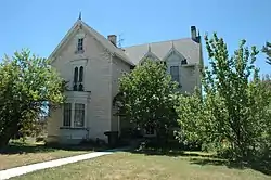 Greaves-Deakin House |
October 3, 1980 (#80003942) |
118 S. Main St. 39°21′27″N 111°35′13″W |
Ephraim | |
| 28 | Hans A. Hansen House |  Hans A. Hansen House |
October 22, 1980 (#80003943) |
75 W. 100 North 39°21′41″N 111°35′15″W |
Ephraim | |
| 29 | Peter Hansen House |  Peter Hansen House |
February 1, 1983 (#83003187) |
247 S. 200 East 39°15′42″N 111°37′56″W |
Manti | |
| 30 | Niels P. Hjort House |  Niels P. Hjort House |
October 3, 1980 (#80003946) |
26 S. State St. 39°37′40″N 111°26′20″W |
Fairview | |
| 31 | Frederick C. Jensen House | April 19, 1982 (#82004158) |
215 S. 100 West 39°32′37″N 111°27′25″W |
Mount Pleasant | 1891 house of Danish immigrant, Victorian Eclectic in style. | |
| 32 | Hans C. Jensen House | February 1, 1983 (#83003188) |
263 E. 100 South 39°21′29″N 111°34′49″W |
Ephraim | Pair house built around 1870, two rooms deep. | |
| 33 | Rasmus Jensen House |  Rasmus Jensen House |
February 1, 1983 (#83003189) |
97 E. 100 South 39°21′30″N 111°35′04″W |
Ephraim | Vernacular pair house built probably in the 1870s |
| 34 | Robert Johnson House | 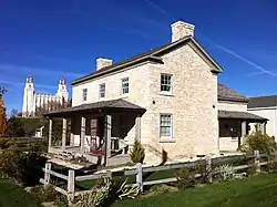 Robert Johnson House |
October 14, 1980 (#80003949) |
103 E. 300 North 39°16′13″N 111°38′02″W |
Manti | |
| 35 | Johnson-Nielson House | 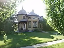 Johnson-Nielson House |
July 26, 1982 (#82004156) |
351 N. Main St. 39°22′00″N 111°35′12″W |
Ephraim | |
| 36 | Francis Marion Jolley House | 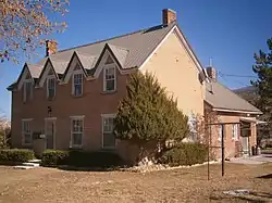 Francis Marion Jolley House |
October 14, 1980 (#80003950) |
201 S. 200 E. 39°15′44″N 111°37′59″W |
Manti | 1875 brick house of English immigrant, with four dormer windows above first-floor window-door-window-window arrangement. |
| 37 | Oluf Larsen House |  Oluf Larsen House |
February 1, 1983 (#83003190) |
75 S. 100 West 39°21′31″N 111°35′21″W |
Ephraim | Pair-house built in 1870. |
| 38 | Larsen-Noyes House | 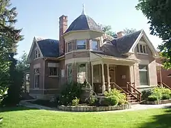 Larsen-Noyes House |
December 1, 1978 (#78002688) |
96 E. Center St. 39°21′34″N 111°35′01″W |
Ephraim | |
| 39 | John T. Lewellyn House |  John T. Lewellyn House |
October 3, 1980 (#80003958) |
15 N. State St. 39°29′09″N 111°38′07″W |
Wales | Brick hall-and-parlor plan house built in 1875. |
| 40 | David and Evinda Madsen House |  David and Evinda Madsen House |
July 3, 2014 (#14000383) |
65 N. 100 W. 39°21′40″N 111°35′23″W |
Ephraim | Brick house built in 1900, with Italianate/Victorian Eclectic styling. David Madsen helped bring sheep ranching to the area. |
| 41 | Manti Carnegie Library | 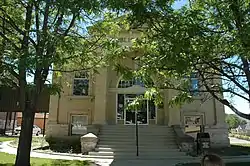 Manti Carnegie Library |
October 25, 1984 (#84000150) |
2 S. Main St. 39°15′54″N 111°38′14″W |
Manti | Presumably a Carnegie library. |
| 42 | Manti City Hall |  Manti City Hall |
June 27, 1985 (#85001397) |
191 N. Main St. 39°16′08″N 111°38′32″W |
Manti | |
| 43 | Manti Motor Company Building | 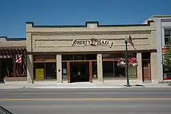 Manti Motor Company Building |
May 7, 2008 (#08000384) |
87 N. Main St. 39°16′00″N 111°38′13″W |
Manti | |
| 44 | Manti National Guard Armory | 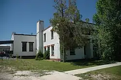 Manti National Guard Armory |
April 9, 1986 (#86000744) |
50 E. 100 North 39°16′00″N 111°38′08″W |
Manti | |
| 45 | Manti Presbyterian Church | 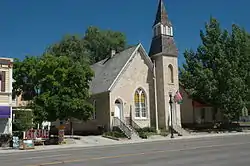 Manti Presbyterian Church |
March 27, 1980 (#80003951) |
185 S. Main St. 39°15′42″N 111°38′08″W |
Manti | |
| 46 | Manti Temple | 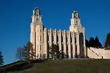 Manti Temple |
August 12, 1971 (#71000854) |
Northern edge of Manti, on U.S. Route 89 39°16′23″N 111°37′59″W |
Manti | |
| 47 | James and Caroline M. Metcalf House |  James and Caroline M. Metcalf House |
July 23, 1998 (#98000905) |
290 E. 500 South 39°08′43″N 111°48′32″W |
Gunnison | |
| 48 | Moroni High School Mechanical Arts Building |  Moroni High School Mechanical Arts Building |
April 1, 1985 (#85000812) |
350 N. Center St. 39°31′50″N 111°35′00″W |
Moroni | Now with strange portico? |
| 49 | Moroni Opera House |  Moroni Opera House |
May 23, 1996 (#96000590) |
325 W. Main St. 39°31′29″N 111°35′25″W |
Moroni | Stone and brick building completed in 1891. |
| 50 | Mortensen-Nelson House | 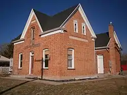 Mortensen-Nelson House |
July 10, 2003 (#03000632) |
291 E. 100 South 39°31′25″N 111°34′43″W |
Moroni | c.1885 brick double cross-wing house. |
| 51 | Mount Pleasant Carnegie Library | 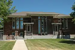 Mount Pleasant Carnegie Library |
October 25, 1984 (#84000152) |
24 E. Main St. 39°32′48″N 111°27′14″W |
Mount Pleasant | Presumably another Carnegie library |
| 52 | Mount Pleasant Commercial Historic District |  Mount Pleasant Commercial Historic District |
October 26, 1979 (#79002508) |
U.S. Route 89 and State Route 116 39°32′46″N 111°27′22″W |
Mount Pleasant | |
| 53 | Mount Pleasant High School Mechanical Arts Building |  Mount Pleasant High School Mechanical Arts Building |
April 1, 1985 (#85000813) |
150 N. State St. 39°32′58″N 111°27′16″W |
Mount Pleasant | 1935-36 public works project |
| 54 | Mount Pleasant National Guard Armory |  Mount Pleasant National Guard Armory |
April 9, 1986 (#86000740) |
10 N. State St. 39°32′50″N 111°27′17″W |
Mount Pleasant | PWA Moderne armory built in 1936-37. |
| 55 | Jens Nielsen House | 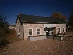 Jens Nielsen House |
February 1, 1983 (#83003191) |
192 W. 200 South 39°21′23″N 111°35′30″W |
Ephraim | C.1870 pair house of tripartite ("Type IV" type), with indented porch in center section. |
| 56 | John R. Nielson Cabin | June 8, 2004 (#03000772) |
Forest Road 1232, about 9 miles (14 km) up Manti Canyon 39°16′01″N 111°30′04″W |
Manti | Log cabin built in 1948. | |
| 57 | N.S. Nielson House |  N.S. Nielson House |
July 26, 1982 (#82004160) |
179 W. Main St. 39°32′47″N 111°27′32″W |
Mount Pleasant | Eclectic Victorian house built in 1892, home of a bank president and mayor, with unusual mansard-roofed tower. |
| 58 | Oberg-Metcalf House | 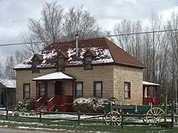 Oberg-Metcalf House |
November 24, 1997 (#97001464) |
12 N. 100 East 39°09′19″N 111°49′05″W |
Gunnison | |
| 59 | Hans Peter Olsen House |  Hans Peter Olsen House |
April 22, 1976 (#76001834) |
211 S. State St. 39°37′31″N 111°38′03″W |
Fountain Green | "One of the finest pioneer brick homes in Sanpete County", built in 1877. |
| 60 | Hans Ottesen House | 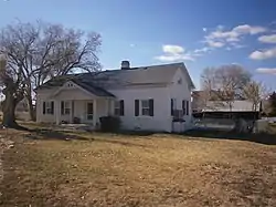 Hans Ottesen House |
August 6, 1987 (#87001177) |
202 S. 200 West 39°15′44″N 111°38′28″W |
Manti | Pair-house of Danish immigrant. |
| 61 | John Patten House | 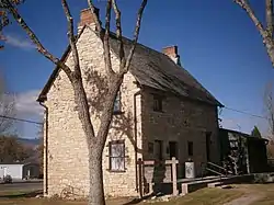 John Patten House |
August 22, 1977 (#77001315) |
NE corner of W. 300 N. and N. 100 W. 39°16′12″N 111°38′19″W |
Manti | Primitive vernacular two-story house, built in 1854. |
| 62 | Pectol-Works House | 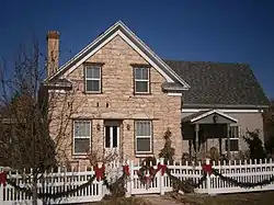 Pectol-Works House |
July 30, 2019 (#100004223) |
96 West 400 North 39°16′17″N 111°38′19″W |
Manti | |
| 63 | Canute Peterson House | 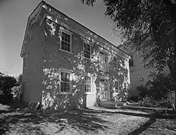 Canute Peterson House |
July 17, 1978 (#78002689) |
10 N. Main St. 39°21′36″N 111°35′09″W |
Ephraim | |
| 64 | Poulsen-Hall House | 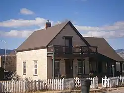 Poulsen-Hall House |
April 27, 2011 (#11000235) |
90 S. 100 East 39°15′51″N 111°38′07″W |
Manti | |
| 65 | Morten Rasmussen House | 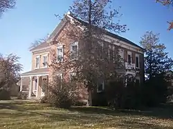 Morten Rasmussen House |
August 18, 1977 (#77001317) |
12 S. 400 West 39°32′47″N 111°27′46″W |
Mount Pleasant | |
| 66 | Sanpete County Courthouse | 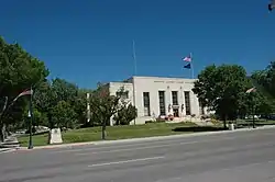 Sanpete County Courthouse |
April 1, 1985 (#85000811) |
160 N. Main St. 39°16′05″N 111°38′09″W |
Manti | |
| 67 | William Stuart Seeley House | 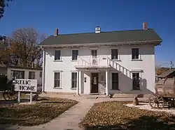 William Stuart Seeley House |
July 16, 1992 (#92000894) |
150 S. State St. 39°32′41″N 111°27′18″W |
Mount Pleasant | |
| 68 | John H. Seely House | 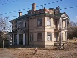 John H. Seely House |
March 9, 1982 (#82004159) |
91 S. 5th West 39°32′44″N 111°27′50″W |
Mount Pleasant | |
| 69 | Ezra and Abigail Shomaker House | 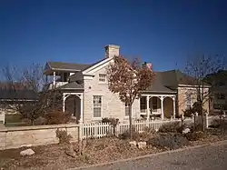 Ezra and Abigail Shomaker House |
October 15, 2014 (#14000864) |
194 W. 400 North 39°16′17″N 111°38′26″W |
Manti | |
| 70 | Snow Academy Building | 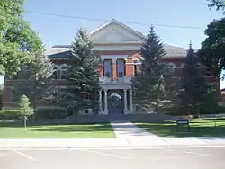 Snow Academy Building |
November 20, 1987 (#87002062) |
150 College Ave. 39°21′40″N 111°34′56″W |
Ephraim | |
| 71 | Dykes Sorensen House | October 20, 1982 (#82001756) |
302 S. 200 East 39°21′15″N 111°34′56″W |
Ephraim | Pair house, apparently incomplete two-room version of what would have been a three-room plan, built c.1870. | |
| 72 | Fredrick Christian Sorensen House |  Fredrick Christian Sorensen House |
October 14, 1980 (#80003944) |
62 E. Center St. 39°21′35″N 111°35′06″W |
Ephraim | |
| 73 | Spring City Historic District |  Spring City Historic District |
October 22, 1980 (#80003957) |
State Route 117 39°28′37″N 111°29′47″W |
Spring City | |
| 74 | Spring City School | 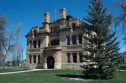 Spring City School |
November 14, 1978 (#78002691) |
45 S. 100 East 39°28′40″N 111°29′35″W |
Spring City | |
| 75 | Alma Staker House | 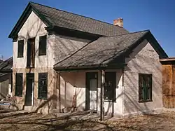 Alma Staker House |
July 9, 1979 (#79002509) |
81 E. 300 South 39°32′33″N 111°27′14″W |
Mount Pleasant | Built in eastern style, of western materials. |
| 76 | James B. Staker House |  James B. Staker House |
October 3, 1980 (#80003954) |
211 N. State St. 39°33′00″N 111°27′19″W |
Mount Pleasant | |
| 77 | Tuttle-Folsom House |  Tuttle-Folsom House |
July 21, 1977 (#77001316) |
195 W. 300 North 39°16′10″N 111°38′26″W |
Manti | Stone house with early Saltbox-type addition to the rear. |
| 78 | Wales Co-operative Mercantile Institution | 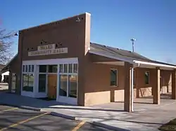 Wales Co-operative Mercantile Institution |
September 29, 2000 (#00001176) |
150 N. State St. 39°29′15″N 111°38′06″W |
Wales | Western false front one-story building |
| 79 | Wasatch Academy |  Wasatch Academy |
October 2, 1978 (#78002690) |
200 S. 100 West 39°32′39″N 111°27′26″W |
Mount Pleasant | |
| 80 | Watkins-Tholman-Larsen Farmstead |  Watkins-Tholman-Larsen Farmstead |
December 27, 1996 (#96001531) |
422 E. 400 South St. 39°32′26″N 111°26′51″W |
Mount Pleasant | Property with historic picket fence, clapboarded log house, granary, barn, blacksmith shop, and stone chicken coop. |
| 81 | Cyrus Wheelock House | October 3, 1980 (#80003955) |
200 E. 100 North 39°32′55″N 111°27′05″W |
Mount Pleasant | Adobe house built around 1860. Appears to have been considerably transformed in recent years. |
Former listing
| [3] | Name on the Register | Image | Date listed | Date removed | Location | City or town | Summary |
|---|---|---|---|---|---|---|---|
| 1 | George Washington Bradley House | October 22, 1980 (#80003952) | August 26, 1983 | 100 S. 200 West |
Moroni |
See also
References
- The latitude and longitude information provided in this table was derived originally from the National Register Information System, which has been found to be fairly accurate for about 99% of listings. Some locations in this table may have been corrected to current GPS standards.
- "National Register of Historic Places: Weekly List Actions". National Park Service, United States Department of the Interior. Retrieved on February 5, 2021.
- Numbers represent an alphabetical ordering by significant words. Various colorings, defined here, differentiate National Historic Landmarks and historic districts from other NRHP buildings, structures, sites or objects.
- "National Register Information System". National Register of Historic Places. National Park Service. April 24, 2008.
- The eight-digit number below each date is the number assigned to each location in the National Register Information System database, which can be viewed by clicking the number.
External links
![]() Media related to National Register of Historic Places in Sanpete County, Utah at Wikimedia Commons
Media related to National Register of Historic Places in Sanpete County, Utah at Wikimedia Commons
 | |||
| Topics | |
|---|---|
| Lists by state |
|
| Lists by insular areas | |
| Lists by associated state | |
| Other areas | |
| Related | |
| |
Municipalities and communities of Sanpete County, Utah, United States | ||
|---|---|---|
| Cities | Map of Utah highlighting Sanpete County | |
| Towns | ||
| Unincorporated communities | ||
| Ghost towns | ||
| ||