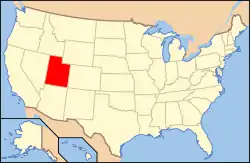
National Register of Historic Places listings in Duchesne County, Utah
This is a list of the National Register of Historic Places listings in Duchesne County, Utah.
This is intended to be a complete list of the properties and districts on the National Register of Historic Places in Duchesne County, Utah, United States. Latitude and longitude coordinates are provided for many National Register properties and districts; these locations may be seen together in a map.[1]
There are 38 properties and districts listed on the National Register in the county. 34 of these properties are archaeological sites in Nine Mile Canyon, and little is publicly made available about those sites beyond their names, almost all of which are given as Smithsonian trinomial codes. Another property was once listed but has been removed.
- This National Park Service list is complete through NPS recent listings posted February 5, 2021.[2]
Current listings
| [3] | Name on the Register[4] | Image | Date listed[5] | Location | City or town | Description |
|---|---|---|---|---|---|---|
| 1 | 42Dc306 | November 30, 2009 (#09001040) |
Address Restricted |
Wellington | Archaeological site in Nine Mile Canyon | |
| 2 | 42Dc0331 | September 12, 2012 (#12000772) |
Address Restricted |
Wellington | Archaeological site in Nine Mile Canyon | |
| 3 | 42Dc0530 | September 12, 2012 (#12000773) |
Address Restricted |
Wellington | Archaeological site in Nine Mile Canyon, a scattering of stone artifacts | |
| 4 | 42Dc638 | November 30, 2009 (#09001039) |
Address Restricted |
Wellington | Archaeological site in Nine Mile Canyon, including a storage cist, rock alignment, and stone artifacts | |
| 5 | 42Dc0645 | September 12, 2012 (#12000774) |
Address Restricted |
Wellington | Archaeological site in Nine Mile Canyon, a prehistoric cairn | |
| 6 | 42Dc682 | November 30, 2009 (#09001026) |
Address Restricted |
Wellington | Archaeological site in Nine Mile Canyon, a historical-era campsite consisting of a campfire ring and artifact | |
| 7 | 42Dc683 | November 30, 2009 (#09001027) |
Address Restricted |
Wellington | Archaeological site in Nine Mile Canyon, a rock shelter containing evidence of maize agriculture | |
| 8 | 42Dc684 | November 30, 2009 (#09001038) |
Address Restricted |
Wellington | Archaeological site in Nine Mile Canyon, a storage cist | |
| 9 | 42Dc685 | November 30, 2009 (#09001037) |
Address Restricted |
Wellington | Archaeological site in Nine Mile Canyon, a rock alignment | |
| 10 | 42Dc686 | November 30, 2009 (#09001036) |
Address Restricted |
Wellington | Archaeological site in Nine Mile Canyon, including two granaries | |
| 11 | 42Dc687 | November 30, 2009 (#09001035) |
Address Restricted |
Wellington | Archaeological site in Nine Mile Canyon, a rock alignment | |
| 12 | 42Dc688 | November 30, 2009 (#09001034) |
Address Restricted |
Wellington | Archaeological site in Nine Mile Canyon | |
| 13 | 42Dc696 | November 30, 2009 (#09001025) |
Address Restricted |
Wellington | Archaeological site in Nine Mile Canyon, an improved trail through a breach in the north canyon face, lined with a stone wall and wooden cross beams | |
| 14 | 42Dc700 | November 30, 2009 (#09001022) |
Address Restricted |
Wellington | Archaeological site in Nine Mile Canyon | |
| 15 | 42Dc702 | November 30, 2009 (#09001033) |
Address Restricted |
Wellington | Archaeological site in Nine Mile Canyon, a single pithouse with rock alignment and petroglyphs | |
| 16 | 42Dc703 | November 30, 2009 (#09001031) |
Address Restricted |
Wellington | Archaeological site in Nine Mile Canyon, a rock shelter | |
| 17 | 42Dc704 | November 30, 2009 (#09001030) |
Address Restricted |
Wellington | Archaeological site in Nine Mile Canyon, a walled structure built on a cliff, with two granaries and some artifacts | |
| 18 | 42Dc705 | November 30, 2009 (#09001023) |
Address Restricted |
Wellington | Archaeological site in Nine Mile Canyon | |
| 19 | 42Dc708 | November 30, 2009 (#09001029) |
Address Restricted |
Wellington | Archaeological site in Nine Mile Canyon, a single pithouse with some ceramic and stone artifacts | |
| 20 | 42Dc709 | November 30, 2009 (#09001028) |
Address Restricted |
Wellington | Archaeological site in Nine Mile Canyon, a granary | |
| 21 | 42Dc710 | November 30, 2009 (#09001024) |
Address Restricted |
Wellington | Archaeological site in Nine Mile Canyon | |
| 22 | 42Dc712 | November 30, 2009 (#09001032) |
Address Restricted |
Wellington | Archaeological site in Nine Mile Canyon, a pithouse | |
| 23 | 42Dc1302 | September 12, 2012 (#12000775) |
Address Restricted |
Wellington | Archaeological site in Nine Mile Canyon, including a fence and wall with petroglyphs | |
| 24 | 42Dc1618 | September 12, 2012 (#12000776) |
Address Restricted |
Wellington | Archaeological site in Nine Mile Canyon, a granary | |
| 25 | 42Dc1619 | September 12, 2012 (#12000758) |
Address Restricted |
Wellington | Archaeological site in Nine Mile Canyon, including petroglyphs | |
| 26 | 42Dc1620 | September 12, 2012 (#12000837) |
Address Restricted |
Wellington | Archaeological site in Nine Mile Canyon, including petroglyphs | |
| 27 | Centennial House | November 30, 2009 (#09001042) |
Address Restricted |
Wellington | Archaeological site in Nine Mile Canyon | |
| 28 | Fool's Pinnacle | November 30, 2009 (#09001041) |
Address Restricted |
Wellington | Archaeological site in Nine Mile Canyon, a circular stone structure with a small square window atop a high pinnacle, very difficult to access | |
| 29 | Indian Canyon Ranger Station | October 28, 1999 (#99001294) |
State Route 33 in the Duchesne Ranger District 39°55′37″N 110°40′34″W |
Duchesne | ||
| 30 | Karen's Cist | November 30, 2009 (#09001043) |
Address Restricted |
Wellington | Archaeological site in Nine Mile Canyon | |
| 31 | Maxies Pad | November 30, 2009 (#09001044) |
Address Restricted |
Wellington | Archaeological site in Nine Mile Canyon | |
| 32 | Myton Presbyterian Church | 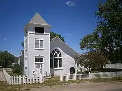 Myton Presbyterian Church |
September 18, 2017 (#100001638) |
225 E 100 S 40°11′36″N 110°03′35″W |
Myton | |
| 33 | Nordell's Fort | November 30, 2009 (#09001045) |
Address Restricted |
Wellington | Archaeological site in Nine Mile Canyon, a coursed masonry structure, 7 feet (2.1 m) high, located on a narrow rock outcropping | |
| 34 | Redman Village | 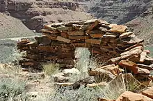 Redman Village |
November 30, 2009 (#09001047) |
Address Restricted |
Wellington | Archaeological site in Nine Mile Canyon, a cluster of stone shelters on a terrace overlooking the canyon, named for a red anthropomorphic pictograph on the adjacent cliff |
| 35 | Simmons Ranch | August 18, 1992 (#92000463) |
8 miles (13 km) south of U.S. Route 40 40°07′27″N 110°46′36″W |
Fruitland | ||
| 36 | Stockmore Ranger Station |  Stockmore Ranger Station |
November 12, 1999 (#99001293) |
State Route 35 in the Duchesne Ranger District 40°28′11″N 110°50′24″W |
Tabiona | |
| 37 | Sunstone Village | November 30, 2009 (#09001046) |
Address Restricted |
Wellington | Archaeological site in Nine Mile Canyon, a group of rock shelters on a narrow mesa with precipitous drops on all but one side | |
| 38 | Taylor's City | November 30, 2009 (#09001048) |
Address Restricted |
Wellington | Archaeological site in Nine Mile Canyon |
Former listing
| [3] | Name on the Register | Image | Date listed | Date removed | Location | City or town | Summary |
|---|---|---|---|---|---|---|---|
| 1 | Toyack Future Farmers of America Chapter House | May 18, 1984 (#84002175) | April 28, 2005 | 340 North 300 West |
Roosevelt |
See also
References
- The latitude and longitude information provided in this table was derived originally from the National Register Information System, which has been found to be fairly accurate for about 99% of listings. Some locations in this table may have been corrected to current GPS standards.
- "National Register of Historic Places: Weekly List Actions". National Park Service, United States Department of the Interior. Retrieved on February 5, 2021.
- Numbers represent an alphabetical ordering by significant words. Various colorings, defined here, differentiate National Historic Landmarks and historic districts from other NRHP buildings, structures, sites or objects.
- "National Register Information System". National Register of Historic Places. National Park Service. April 24, 2008.
- The eight-digit number below each date is the number assigned to each location in the National Register Information System database, which can be viewed by clicking the number.
External links
![]() Media related to National Register of Historic Places in Duchesne County, Utah at Wikimedia Commons
Media related to National Register of Historic Places in Duchesne County, Utah at Wikimedia Commons
 | |||
| Topics | |
|---|---|
| Lists by state |
|
| Lists by insular areas | |
| Lists by associated state | |
| Other areas | |
| Related | |
| |
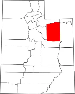
Municipalities and communities of Duchesne County, Utah, United States | ||
|---|---|---|
| Cities | Map of Utah highlighting Duchesne County | |
| Towns | ||
| CDPs | ||
| Unincorporated communities | ||
| Indian reservation | ||
| Ghost town | ||
| Footnotes | ‡This populated place also has portions in an adjacent county or counties | |
| ||