Ninoy Aquino Avenue
Ninoy Aquino Avenue is a north-south collector road that links Pasay and Parañaque in southern Metro Manila, Philippines.[1] It serves as an extension of Dr. Santos Avenue (formerly Sucat Road) and as a feeder to the Ninoy Aquino International Airport (NAIA) from the south and east. Like the airport it passes through, it is named for Filipino Senator Benigno "Ninoy" Aquino.
.svg.png.webp) | |
|---|---|
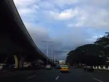
 Ninoy Aquino Avenue view northbound towards NAIA Road | |
| Former name(s) | Imelda Avenue |
| Part of | |
| Namesake | Benigno S. Aquino, Jr. Imelda Marcos (formerly) |
| Maintained by | Department of Public Works and Highways |
| Length | 3.2 km (2.0 mi) |
| North end | |
| Major junctions | Multinational Avenue |
| South end | |
Route description
The road commences at the junction with A. Bonifacio Street and the road into Amvel City in Barangay San Dionisio, Parañaque as a continuation of Dr. Santos Avenue. It then travels north toward the old NAIA Terminal 1, traversing Barangays La Huerta and Santo Niño. Notable landmarks include the Dampa Seafood Market, the former Casino Filipino Airport, and Duty Free Fiestamall. It then enters Pasay where it is also known by its former name Imelda Avenue, after former Filipina first lady Imelda Marcos. The avenue terminates at the intersection with NAIA Road near the ramps of the NAIA Expressway.[2]
Intersections
| Province | City/Municipality | km | mi | Destinations | Notes |
|---|---|---|---|---|---|
| Pasay | Traffic light intersection. Northern terminus. | ||||
| Southbound entrance only | |||||
| Southbound exit only | |||||
| Northbound entrance only | |||||
| Pasay – Parañaque boundary | Cut-cut Bridge over Cut-cut Creek | ||||
| Parañaque | Northbound access only | ||||
| Pascor Drive | Southbound access only | ||||
| E. Rodriguez Street / J.P. Rizal Street | Traffic light intersection. Access to Barangay Santo Niño and | ||||
| Duty Free Fiestamall | Traffic light intersection. | ||||
| Multinational Avenue | Former traffic light intersection. No left turn allowed to Ninoy Aquino Avenue from Multinational Avenue. | ||||
| Col. E.L. De Leon Street | Southbound access only | ||||
| Sto. Niño Bridge over Parañaque River | |||||
| N. de Leon Street | Southbound access only | ||||
| Global Airport Business Park Road | Northbound access only. Access to C-5 Extension. | ||||
| I. Capistrano Street | Southbound access only | ||||
| Amvel City | Traffic light intersection. Access to C-5 Extension. | ||||
| Victor Medina Street | Traffic light intersection. Access to | ||||
| Amvel City | |||||
| Traffic light intersection. Southern terminus. Continues south as | |||||
| 1.000 mi = 1.609 km; 1.000 km = 0.621 mi | |||||
References
- Roads and Transport published by the Pasay City Government; accessed 2013-10-29.
- "Road and Bridge Inventory". www.dpwh.gov.ph. Retrieved July 5, 2020.