Timog Avenue
Timog Avenue is a major road located in Quezon City within the Diliman area of northeastern Metro Manila, Philippines. It runs east–west through the southern edge of the barangay of South Triangle and is used to be named in English as South Avenue. The street is located in Quezon City's entertainment area, known for its trendy restaurants, bars and karaoke and comedy clubs.[2] It is also home to the GMA Network Center studios located on the avenue's junction with Epifanio de los Santos Avenue (EDSA). The entire avenue is designated as National Route 172 (N172) of the Philippine highway network.
.svg.png.webp)  | ||||
|---|---|---|---|---|
| South Avenue | ||||
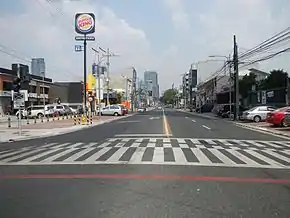 Timog Avenue, looking east from the junction with Mother Ignacia Avenue | ||||
| Route information | ||||
| Maintained by the Department of Public Works and Highways – Quezon City 2nd Engineering District Office[1] | ||||
| Length | 2.040 km (1.268 mi) | |||
| Major junctions | ||||
| West end | ||||
| East end | ||||
| Location | ||||
| Major cities | Quezon City | |||
| Highway system | ||||
| ||||
Route description
Timog Avenue is a four-lane road located at the heart of Quezon City's entertainment district. It begins at its junction with EDSA south of East Avenue by South Triangle's border with the central Diliman village of Pinyahan. It heads west from this junction to cross GMA Network Drive and Sergeant Esguerra Avenue towards the 11th World Scout Jamboree Memorial Rotonda on the intersection with Tomas Morato Avenue. Located on or near this eastern section of Timog are the GMA studios, Kamuning MRT Station, Tune Hotel Quezon City, and Imperial Palace Suites Hotel. After crossing the Boy Scout circle, the avenue is dominated by more commercial establishments, including The Shoppes at Victoria which houses a Robinsons Supermarket, Luxent Hotel (positioned as an upscale Business and Family-friendly hotel), Torre Venezia and the Toyama Center. Located on this western section are many popular restaurants, comedy clubs, and cosmetic salons which cater to local actors working in nearby studios. The avenue terminates at the junction with Quezon Avenue south of West Avenue near West Triangle.
History
The avenue forms the southern boundary of the formerly proposed 400-hectare (990-acre) Diliman Quadrangle within the former Diliman Estate also known as Hacienda de Tuason, purchased by the Philippine Commonwealth government in 1939 as the new capital to replace Manila.[3] It was originally planned as the new city's Central Park housing the new national government buildings (the new Presidential palace, Capitol Building, and Supreme Court complex) within the 25-hectare (62-acre) elliptical site now known as the Quezon Memorial Circle. The quadrangle is bordered on the north by North Avenue, on the east by East Avenue, on the south by Timog (South) Avenue, and on the west by West Avenue. Designed by American city planner William E. Parsons and Harry Frost, in collaboration with engineer AD Williams and architects Juan Arellano and Louis Croft, the site was also to contain the 15-hectare (37-acre) national exposition grounds opposite the corner of North Avenue and EDSA (now occupied by SM City North EDSA).[3] The Diliman Quadrangle had been largely undeveloped for decades due to lack of funding. After several revisions, the government planners moved the city center to Novaliches due to its higher elevation.[4] On April 24, 1964, the Quezon City council renamed streets in the area commemorated at the 11th World Scout Jamboree the previous year, it was to be renamed Boy Scouts Avenue, but the government disagreed, however the street eventually renamed Timog Avenue (Tagalog for South).[5] By 1976, the country's capital had been transferred back to Manila with only the Quezon Memorial built in the former capital site.
Intersections
The entire route is located in Quezon City.
| km | mi | Destinations | Notes | ||
|---|---|---|---|---|---|
| Traffic light intersection. Western terminus. Continues as | |||||
| Panay Avenue | |||||
| Mother Ignacia Avenue, Scout Santiago Street | |||||
| Scout Tobias Street | Alternative route to E.Rodriguez Sr. Ave via Tobias—Hemady Bridge | ||||
| Scout Tuazon Street | |||||
| Tomas Morato Avenue | 11th World Scout Jamboree Memorial Rotonda | ||||
| Scout Torillo Street | |||||
| Scout Ybardolaza Street | |||||
| Sergeant Esguerra Street, 11th Jamboree Street, GMA Network Drive | Southbound goes to Kamuning Road | ||||
| Samar Avenue | |||||
| Traffic light intersection. Eastern terminus. Continues as | |||||
| 1.000 mi = 1.609 km; 1.000 km = 0.621 mi | |||||
References
- "Quezon City 2nd". Department of Public Works and Highways. Retrieved November 8, 2020.
- "Business brings more fun in Quezon City". Quezon City Business. Retrieved 16 May 2015.
- "The 1946 Quezon City world's fair". The Philippine Star. Retrieved 16 May 2015.
- "25 things you didn't know about Quezon City". The Philippine Star. Retrieved 16 May 2015.
- Quezon City Public Library Local History Section - Blogspot
