10th Avenue, Caloocan
10th Avenue, formerly known as Macario Asistio Sr. Avenue or simply Asistio Avenue, is a four-lane undivided street in Caloocan, Metro Manila, Philippines that stretches east–west, bisecting South Caloocan. Like most avenues in this area of Grace Park, it crosses a near-perfect grid system of numbered streets that run north–south, with other numbered avenues running east–west. 10th Avenue was formally renamed to Asistio Avenue prior to reverting it to its current numbered name owing to it being the tenth avenue running east–west from the city's border with Manila in the south. The former renaming was done in 1984 to honor the former Mayor of Caloocan who served from 1962 to 1971 and the father of another Caloocan mayor Boy Asistio, but has since been disregarded and reverted.[1]
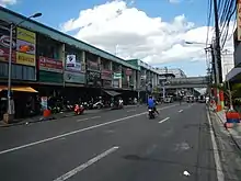 10th Avenue near Rizal Avenue with the elevated Line 1 visible in the background | |
| Former name(s) | Macario Asistio Sr. Avenue / Asistio Avenue |
|---|---|
| Type | Tertiary road |
| Length | 2.2 km (1.4 mi) |
| Location | Caloocan |
| West end | Hizon Street in Grace Park West (Barangay 64) |
| Major junctions |
|
| East end | Kamantigue Street in Grace Park East (Barangay 98) |
10th Avenue and the present-day Grace Park district through which it travels was a pre-World War II civilian airfield known as the Manila North Airfield or Grace Park. This airfield, which opened in 1935 near the then-newly built Bonifacio Monument, was Manila's first commercial airport that served as a hub for Philippine Airlines for its first domestic routes. The airport was decommissioned after the war and was transformed by the government into a residential and industrial area.[2][3]
Route description

10th Avenue is a national road classified by the Department of Public Works and Highways as a tertiary road.[4] The road runs for 2.2 kilometres (1.4 mi) from its western terminus at the intersection of M. Hizon Street and the Philippine National Railways line in Grace Park West to its eastern terminus at Kamantigue Street in Barrio Galino, close to A. Bonifacio Avenue at the city's border with Barangays Balingasa and Pag-Ibig sa Nayon in Balintawak, Quezon City.
The avenue is divided into two segments by Rizal Avenue which also serves as the dividing line between Grace Park West and Grace Park East. At its western segment, 10th Avenue begins just east of the 10th Avenue railway station in Barangay 64 and curves slightly to the north before the intersection with Vibora Street and straightens out as it crosses several streets towards Rizal Avenue. Landmarks along this segment include the Caloocan public library, Caloocan High School and Caloocan City Science High School. East of Rizal Avenue, it runs in an almost perfectly straight line to its other terminus in Grace Park East. Located along this segment is the Caloocan campus of Systems Plus College Foundation. The New Caloocan City Hall is accessible via 8th and 9th Streets, a full block south of 10th Avenue.
At the avenue's west end, it continues as Padre Burgos Street through Caloocan's poblacion and Dagat-Dagatan districts, providing access to the Caloocan Judicial Complex, Caloocan Poblacion Market, Caloocan Central Elementary School, and the Caloocan Cathedral.
References
- The Corpus Juris. "An Act Changing the Name of 10Th Avenue (East and West) in the City of Caloocan, Metropolitan Manila, to Daang Macario B. Asistio, Sr". Retrieved 2 April 2019.
- "Grace Park Airfield (Manila North)". Pacific Wrecks. Retrieved 2 April 2019.
- Lazatin, Hannah (16 May 2018). "A Rare Look at the Glory Days of the Manila International Airport". Town & Country. Archived from the original on 2 April 2019. Retrieved 2 April 2019.
- "2017 Road Data: National Capital Region". Department of Public Works and Highways. Archived from the original on 8 October 2018. Retrieved 2 April 2019.