Taft Avenue
Taft Avenue (Filipino: Abenida Taft; Spanish: Avenida Taft) is a major road in the south of Metro Manila. It passes through three cities in the metropolis: Manila, Pasay and Parañaque. The road was named after the former Governor-General of the Philippines and U.S. President, William Howard Taft; the Philippines was a former commonwealth territory of the United States in the first half of the 20th century. The avenue is a component of National Route 170 (N170), a secondary road in the Philippine highway network, and anchors R-2 of the Manila arterial road network. It was previously designated as N1 in the old route numbering system.
.svg.png.webp) R-2 | |
|---|---|
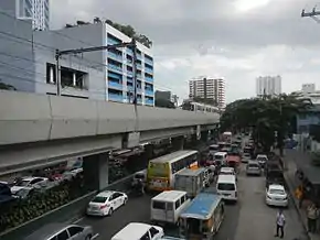
(2017-08-04).jpg.webp) Taft Avenue in Pasay | |
| Former name(s) | Calle Rizal Manila Road Ermita-Pasay Boulevard Mexico Road (extension only) |
| Part of | |
| Namesake | William Howard Taft |
| Maintained by | the Department of Public Works and Highways[1] |
| North end | |
| Major junctions |
|
| South end | Redemptorist Road, Elpidio Quirino Avenue, and Harrison Avenue in Parañaque |
| Construction | |
| Completion | 1899 |
Route description
From the north, Taft Avenue starts at the Lagusnilad vehicular underpass at intersection with Padre Burgos Avenue in Ermita. It then crosses the Ayala Boulevard and Finance Street and forms the eastern edge of Rizal Park up to Kalaw Avenue. It then crosses United Nations Avenue, Padre Faura Street, Pedro Gil Street (formerly known as Herran), where it also crosses the district boundary with Malate, San Andres Street and Quirino Avenue, and Pablo Ocampo Street (formerly known as Vito Cruz Street) before entering the City of Pasay. In Pasay, it crosses Gil Puyat Avenue (formerly known as Buendia Avenue), Arnaiz Avenue (formerly known as Libertad Street), and Epifanio de los Santos Avenue (EDSA), where the intersection is known as Pasay Rotonda. The avenue then continues south towards Baclaran in Parañaque as Taft Avenue Extension up to its terminus at its intersection with Elpidio Quirino Avenue, Harrison Avenue, and Redemptorist Road.
History

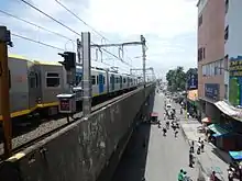
Construction of this avenue, originally called "Calle Rizal", was completed in 1899, with Padre Burgos Avenue (C-1) as its northern terminus and Calle Herran (now Pedro Gil Street) as its southern terminus. Engineers Manny Aquino and Robin Santos led its extension in 1911, and the avenue was renamed Manila Road. However, a map of Manila produced in 1915 by the Office of Department Engineer, Philippine Department, indicates it was named Taft Avenue.[2] It was extended to Ocampo Street (formerly Vito Cruz Street} in 1940, at the height of World War II, during the Japanese occupation of the Philippines. It was further extended to Buendia Avenue (now Gil Puyat Avenue) in 1959 and was named 'Ermita-Pasay Boulevard' or Highway 50, and was further extended to P. Lovina Street or Highway 54 Extension where it ends, with the route continuing as Mexico Road.[3] Afterwards, it was renamed Taft Avenue and Mexico Road became Taft Avenue Extension. The Manila Line 1, the first elevated rail track in the Philippines, was built over it and opened in 1984.
Intersections
This is a list of intersections of Taft Avenue. Bold indicates a street crossings.
Ermita, Manila
- Padre Burgos Avenue (Taft Avenue Extension)
- Mayor Antonio J. Villegas Street (Calle Arroceros)
- Finance Street / Ayala Boulevard (Aurora Boulevard Extension) (C-1)
- Kalaw Avenue (Calle San Luis)
- United Nations Avenue (Calle Isaac Peral) / General Luna Street
- Padre Faura Street
- G. Apacible Street (Calle Oregon)
- Josefa Llanes Escoda Street (Calle California)
- Pedro Gil Street (Calle Herran)
Malate, Manila
- General Malvar Street (Calle Tennessee)
- Julio Nakpil Street (Calle Vermont)
- Remedios Street
- Quirino Avenue (Harrison Boulevard) (C-2) / San Andres Street
- The Century City Road
- Castro Street
- Dagonoy Street
- Sagrada Pamilya Street
- Estrada Street
- Ocampo Street (Calle Vito Cruz)
- Rafael Alunan Street
Pasay City
- Menlo Street
- Inquimboy Street
- Leogardo Street
- Bonifacio Street
- Bernabe Street
- Lakas ng Bayan Street
- San Juan Street
- P. Samonte Street
- Gil Puyat Avenue (Buendia Avenue) (C-3) (closed)
- G. Villanueva Road
- Cartimar Avenue
- Taylo Street
- College Road
- Villareal Street
- Lucban Street
- Arnaiz Avenue (Libertad Street)
- Market Road
- Primero de Mayo Street
- Escobar Street
- S. Raymundo Street
- Lions Road
- Protacio Street
- F. Sanchez Street
- Vergel Street / Pilapil Street (Vergel Street)
- Epifanio de los Santos Avenue (F. Rein Street) (C-4) (Also known as Pasay Rotonda)
- Cuneta Avenue
- Narra Street
Parañaque City
- Harrison Avenue / Elpidio Quirino Avenue (Taft Avenue Extension) / Redemptorist Road (R-2)
Attractions
Rizal Park
One of the three entrances to Rizal Park (the others being Maria Orosa Street and Roxas Boulevard), the Taft Avenue entrance is also adjacent to the National Museum of Fine Arts (formerly Old Legislative Building) and the National Museum of Anthropology (formerly the Finance Building), as well as the Statue of the Sentinel of Freedom.
Government buildings
Taft Avenue is home (or near) to some government buildings: the Supreme Court of the Philippines, Court of Appeals, Department of Tourism, Bureau of Plant Industry, Philippine General Hospital, National Bureau of Investigation and Times Plaza.
World Health Organization
[The office of the World Health Organization Western Pacific Region is located on Taft Avenue, adjacent to the ][LRT Line 1 (Metro Manila)|LRT Line 1]] United Nations station.
University Belt
Taft Avenue forms a part of the University Belt. Universities such as the De La Salle University, College of Saint Benilde, University of the Philippines Manila, Philippine Christian University, Philippine Women's University and the Philippine Normal University are located on Taft Avenue. The Santa Isabel College Manila, Emilio Aguinaldo College, Araullo High School and the Manila Science High School also face the road directly, while Adamson University has direct walkway access from the road.
National Cathedral of the Philippine Independent Church
The National Cathedral of the Holy Child (Holy Infant Jesus) of the Philippine Independent Church is located on Taft Avenue.
Transportation
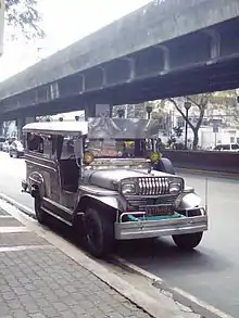
Taft Avenue is accessed through jeepneys, taxis, buses, UV Express, the LRT Line 1, and the MRT Line 3. The avenue houses some LRT Line 1 stations namely: Baclaran station (for Taft Avenue Extension), EDSA (interchange to MRT Line 3 via at Taft Avenue station), Libertad, Gil Puyat, Vito Cruz, Quirino, Pedro Gil, and United Nations.
References
- "South Manila". Retrieved July 17, 2020.
- "Map of city of Manila and vicinity". Library of Congress.
- "Proclamation No. 320, s. 1964". Official Gazette of the Republic of the Philippines. Retrieved 18 June 2015.
| Wikimedia Commons has media related to Taft Avenue. |