Shaw Boulevard
Shaw Boulevard (formerly known as Jose Rizal Boulevard or commonly known as Crossing) is a 4-8 lane highway connecting the cities of Mandaluyong and Pasig in the Philippines. The boulevard is named after William James Shaw, the founder of the Wack Wack Golf and Country Club in Mandaluyong City. The road is one of the major thoroughfares of the Ortigas Center in Mandaluyong and Pasig, housing many shopping malls like the Starmall shopping center and the posh Shangri-La Plaza at the EDSA-Shaw intersection and The Marketplace at the Kalentong-Shaw intersection.[3][4]
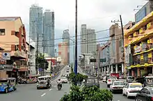 Shaw Boulevard looking southeast towards EDSA-Shaw flyover | |
| Former name(s) | Jose Rizal Boulevard |
|---|---|
| Namesake | William James Shaw |
| Maintained by | Department of Public Works and Highways - Metro Manila 1st District Engineering Office[1] |
| Length | 5.265 km[1][2] (3.272 mi) |
| Component highways |
|
| West end | Sevilla Bridge at Manila–Mandaluyong boundary |
| Major junctions | |
| East end | |
It is served by the Shaw Boulevard station of the MRT-3 along EDSA, often called EDSA-Crossing. The entirety of the road is served by jeepney routes that go to and from Quiapo, Santa Mesa, the José Rizal University, EDSA, the Pasig Public Market, and Binangonan, Rizal.
Route description
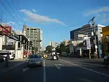
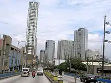
Shaw Boulevard starts as a four-lane road at Sevilla Bridge, which crosses the San Juan River, before coming to an intersection past General Kalentong Street. It is the physical continuation of P. Sanchez Street in Manila. It follows a slightly curved route over Mandaluyong before crossing EDSA. The road expands into four lanes per direction, with two lanes going to the flyover, and two lanes passing below. The flyover carries the road over Shaw Boulevard MRT Station and descends near EDSA Shangri-la. The road becomes a dual six-lane carriageway east of EDSA, and soon enters Pasig. Shaw Boulevard eventually is reduced to a four-lane road and extends to C-5 as Pasig Boulevard.
Landmarks
Shopping Centers
- Ortigas Center
- Shangri-La Plaza
- Crossings Department Store (now Rustan's)
- Starmall EDSA Shaw
- EDSA Central Mall
- SM Cherry Shaw Branch
- S&R Membership Shopping - Shaw
- 500 Shaw Zentrum
- Super8 Grocery Warehouse Shaw
- Puregold Shaw
- Shaw Center Mall
- Metro Supermarket Shaw Center Branch
- SM Hypermart Mandaluyong Branch
- The Marketplace Shopping Mall
Offices
- Worldwide Corporate Center
- Acquire BPO
- E-Telecare Global Solutions CC7 Shaw Site
- ICT
- NetCrossing 2
- AMA Bank
- Solar Entertainment Corporation
- Nine Media Corporation
- CNN Philippines
Transportation
Jeepney / UV Express
- Parklea Jeepney Terminal
- Starmall Jeepney Terminal
- Starmall UV Express Terminal
Railways
Intersections
| Province | City/Municipality | km | mi | Destinations | Notes |
|---|---|---|---|---|---|
| San Juan River | Sevilla Bridge | ||||
| Mandaluyong | Haig Street | Westbound only | |||
| General Kalentong Street | Traffic light intersection; leads to San Juan to the northeast and Santa Ana, Manila to the southwest | ||||
| J. Tiosejo Street | One-way road | ||||
| F. Bernardo Street | One-way road | ||||
| E. Magalona Street / V. Fabella Street | One-way roads | ||||
| A.V. Fabella Street | |||||
| Lawson Street | |||||
| San Clemente Street | |||||
| J.B. Vargas Street | |||||
| E. Jacinto Street | |||||
| Pinagtipunan Street | |||||
| J. Luna Street | |||||
| 29 de Agosto Street | |||||
| L. Gonzales Street / M. Yulo Street | |||||
| L. Cruz Street | |||||
| Araullo Street | Provides access to San Juan | ||||
| R. Vicencio Street / Guerrero Street | |||||
| A. Bonifacio Street | |||||
| Acacia Road | Traffic light intersection; part of Mabuhay Lane Route 1 | ||||
| Gomezville Street / 9 de Febrero Street | Traffic light intersection; northbound goes to San Juan, southbound goes to Maysilo Circle and Poblacion, Makati via Makati-Mandaluyong Bridge | ||||
| Balagtas Street | One-way road | ||||
| Luna Mencias Street | Provides access to San Juan; part of Mabuhay Lane Routes 1 and 4 | ||||
| Torres Street / Jaime Cardinal Sin Street | |||||
| Calderon Street | |||||
| Pilar Street | One way road towards Shaw Boulevard from San Juan | ||||
| A. Mabini Street | One way road from Shaw Boulevard; provides access to San Juan; part of Mabuhay Lane Route 7 | ||||
| Ideal Street | |||||
| S. Laurel Street | One way road towards Shaw Boulevard | ||||
| Lee Street / Old Wack Wack Road | Future traffic light intersection | ||||
| Princeton Street | |||||
| Samat Street | Last intersection on the eastbound direction before the EDSA flyover | ||||
| Stanford Street | Access to/from Shaw Boulevard sealed off | ||||
| West end of EDSA-Shaw Flyover | |||||
| Yale Street | Westbound service road only; access to/from Shaw Boulevard sealed off | ||||
| Harvard Street | Westbound service road only | ||||
| Traffic light intersection | |||||
| Sto. Cristo Street | Eastbound service road only; one-way road | ||||
| Mayflower Street | Eastbound service road only; provides access to Greenfield District; last intersection on the westbound direction before the EDSA flyover | ||||
| East end of EDSA-Shaw Flyover | |||||
| St. Francis Street | Westbound direction only; provides access to Ortigas Center | ||||
| Sheridan Street / San Miguel Avenue | Traffic light intersection; northbound goes to Ortigas Center, southbound goes to Greenfield District | ||||
| Pasig | Escriva Drive | Westbound only; provides access to Ortigas Center | |||
| Pioneer Street / General Roxas Street | Traffic light intersection | ||||
| Meralco Avenue | Traffic light intersection; provides access to Capitol Commons and Ortigas Avenue | ||||
| Camino Verde Road | Westbound only; Capitol Commons internal road | ||||
| West Capitol Drive | Eastbound only; provides access to the Kapitolyo district in Pasig City | ||||
| Oranbo Drive | Westbound only. | ||||
| San Roque Street / Canley Road (Danny Floro Street) | Traffic light intersection | ||||
| Eastern terminus; Hillcrest Drive is not accessible to vehicles coming from Shaw Boulevard | |||||
1.000 mi = 1.609 km; 1.000 km = 0.621 mi
| |||||
References
- "Metro Manila 1st". Department of Public Works and Highways. Retrieved August 2, 2020.
- "Road and Bridge Inventory". www.dpwh.gov.ph. Retrieved August 2, 2020.
- 1
- 2
| Towers |
|  | |||
|---|---|---|---|---|---|
| Shopping centers |
| ||||
| Other landmarks | |||||
| Education | |||||
| Transportation |
| ||||
Italics denote buildings under construction or planned. | |||||