Radial Road 2
Radial Road 2, more commonly referred to as R-2, is a network of roads and bridges that all together form the second arterial road of Manila in the Philippines.[1] The road runs north-south linking the City of Manila to the Metro Manila cities of Pasay, Parañaque and Las Piñas, down to Bacoor, Imus, Dasmariñas, Silang, and Tagaytay in the province of Cavite.
R-2
Radial Road 2 | |
|---|---|
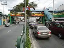
 Taft Avenue, a portion of the R-2 Road, in Ermita, Manila | |
| Route information | |
| Maintained by Department of Public Works and Highways (entire route) and Metro Manila Development Authority (within Metro Manila only) | |
| Length | 64.2 km (39.9 mi) |
| Component highways | |
| Major junctions | |
| North end | |
| South end | |
| Highway system | |
| |
Route
The road consists of the following segments from north to south:
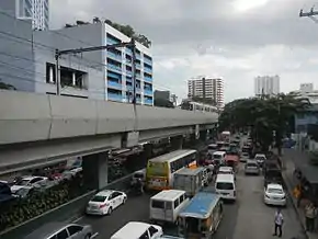
Taft Avenue
Between its northern terminus at the Lagusnilad tunnel of Padre Burgos Avenue and Redemptorist Road in Pasay, R-2 is known as Taft Avenue. It serves the districts of Ermita and Malate running underneath the Manila Light Rail Transit System Line 1 (LRT-1) towards Parañaque via Pasay.
Elpidio Quirino Avenue
Taft Avenue Extension merges with Elpidio Quirino Avenue at the intersection with Redemptorist Road near the Pasay–Parañaque border. This section of R-2 runs the entire length of Parañaque from Baclaran to San Dionisio.
Diego Cera Avenue
R-2 is known as Diego Cera Avenue in Las Piñas. It runs between the Parañaque–Las Piñas border and Alabang–Zapote Road.
Aguinaldo Highway
From Alabang–Zapote Road south to Tagaytay, R-2 is known as Aguinaldo Highway. It is the main north-south thoroughfare in the province of Cavite linking Las Piñas, Metro Manila with Cavite, particularly the cities and municipalities of Bacoor, Imus, Dasmariñas, Silang, and Tagaytay. R-2 ends at the Tagaytay Rotunda, providing the famous view of the Taal Lake.
See also
References
- "Metro Manila Infrastructure Development" (PDF). University of the Philippines Diliman. Retrieved 12 July 2015.