Osmeña Highway
The President Sergio Osmeña Sr. Highway[1] (often shortened as Osmeña Highway), also known as the South Superhighway, is a 4.595-kilometer (2.855 mi) major highway that links Quirino Avenue in Paco, Manila to the South Luzon Expressway (SLEX) and Epifanio de los Santos Avenue (EDSA) at the Magallanes Interchange in Makati.
.svg.png.webp) R-3 | |
|---|---|
| South Superhighway President Sergio Osmeña, Sr. Highway | |
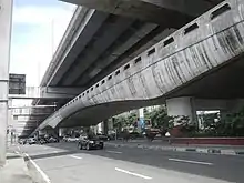
 Osmeña Highway southbound beneath Skyway past the intersection with Arnaiz Avenue in Makati | |
| Route information | |
| Maintained by Department of Public Works and Highways and Metropolitan Manila Development Authority | |
| Length | 4.6 km (2.9 mi) |
| Existed | 1960s–present |
| Component highways | |
| Major junctions | |
| North end | |
| South end | |
| Location | |
| Major cities | Manila and Makati |
| Highway system | |
| |
The highway is designated as a component of National Route 145 (N145) of the Philippine highway network and of Radial Road 3 (R-3) of Metro Manila's arterial road network.
The highway is named after Sergio Osmeña, the 4th President of the Philippines.
Route description

The Osmeña Highway starts at a traffic light intersection with Quirino Avenue in Paco, Manila.[2] It then crosses San Andres Street, Ocampo (Vito Cruz) Street, and Zobel Roxas Street, enters Makati and climbs over to pass above Gil Puyat Avenue through the Buendia Flyover, with service roads to serve that avenue and several side streets.[3] The first stage of Skyway starts on the ramps past Buendia Flyover.[4][5] Osmeña Highway crosses Arnaiz Avenue and soon crosses over EDSA at the Magallanes Interchange, where the South Luzon Expressway starts. Most of the highway parallels the PNR Metro South Commuter Line and runs under the Skyway elevated toll road.[6][7][8]
The part of Osmeña Highway north of Magallanes Interchange is maintained by the Department of Public Works and Highways (DPWH) through the South Manila District Engineering Office and Metro Manila 2nd District Engineering Office in Manila and Makati, respectively.[6][7] The Metropolitan Manila Development Authority (MMDA) has jurisdiction also of both the tolled and non-tolled segments, and maintains motorcycle lanes up to Sales Interchange (Nichols).[9][10]
Currently, Osmeña Highway also refers alternatively to the segment of South Luzon Expressway from Magallanes Interchange to Muntinlupa.[1] It was also applied further south to the province of Laguna until 1992.[11]
History
Osmeña Highway was originally built during the late 1960s as Manila South Diversion Road or South Superhighway from Manila to Alabang, Muntinlupa (then a municipality of Rizal). It served as newer roads used to travel from and to Manila.[12] The construction started in 1967 and was completed on December 16, 1969.
In 1976, the expressway was extended by another 29 kilometers (18 mi) from Alabang up to Calamba, Laguna. The project included the 850-meter-long (0.53 mi) viaduct which crosses over Alabang called Alabang Viaduct. This later on became the boundary when the Philippine National Construction Corporation decided to split the expressway into two concessions which renamed the Nichols to Alabang segment as the South Metro Manila Skyway System while the Alabang to Santo Tomas segment retained the South Luzon Expressway concession branding.[13] South Superhighway was renamed in 1989 to President Sergio Osmeña Sr. Highway, after former President Sergio Osmeña by virtue of Republic Act 6760.[1] The Act was amended in 1992 to rename its segment from kilometer 28.387 at San Pedro, Laguna southwards to Dr. Jose P. Rizal Highway. [11]
Intersections
Intersections are numbered by kilometer posts, with Rizal Park in Manila designated as kilometer zero.
| Province | City/Municipality | km | mi | Destinations | Notes | |||
|---|---|---|---|---|---|---|---|---|
| Manila | 4.090 | 2.541 | Traffic light intersection | |||||
| Skyway | Skyway Quirino Exit; northbound entrance only | |||||||
| 4.650 | 2.889 | San Andres Street | Traffic light intersection. No left turn allowed from either directions. | |||||
| 5.430 | 3.374 | Pablo Ocampo Street | Traffic light intersection; one-way street | |||||
| 5.490 | 3.411 | Zobel Roxas Street | Traffic light intersection; one-way street | |||||
| Makati | Skyway | Buendia Exit of Skyway Stage 3; northbound exit and southbound entrance | ||||||
| North end of Buendia Flyover | ||||||||
| Emilia Street, Malugay Street | Traffic light intersection; no entry to Osmeña Highway from Emilia Street | |||||||
| Traffic light intersection | ||||||||
| Finlandia Street, Dela Rosa Street | Traffic light intersection; no left turn allowed from northbound and no right turn allowed from southbound | |||||||
| South end of Buendia Flyover | ||||||||
| 6.750 | 4.194 | Skyway Buendia Exit; southbound exit and northbound entrance | ||||||
| 7.320 | 4.548 | Arnaiz Avenue | Traffic light intersection; no right turn allowed from northbound and no left turn from southbound | |||||
| 7.800 | 4.847 | Don Bosco Street | Northbound access only; southbound access via U-turn slot under Magallanes Interchange | |||||
| Skyway Don Bosco Exit; northbound entrance | ||||||||
| 8.710 | 5.412 | Magallanes Interchange. Continues south as | ||||||
| 1.000 mi = 1.609 km; 1.000 km = 0.621 mi | ||||||||
References
- Republic Act No. 6760 (September 25, 1989), AN ACT CHANGING THE NAME OF THE SOUTH SUPERHIGHWAY TO PRESIDENT SERGIO OSMEÑA SR. HIGHWAY, retrieved February 5, 2021
- "Osmeña Highway, Quirino Ave affected by Skyway construction". Rappler. Retrieved February 3, 2021.
- "Angkas, motorcycle groups question sub-400cc ban in Osmeña Highway". Rappler. Retrieved February 3, 2021.
- "METRO MANILA SKYWAY STAGE 3 (MMSS-3) | Department of Public Works and Highways". www.dpwh.gov.ph. Retrieved February 3, 2021.
- "Skyway O&M Corporation". Skyway O&M Corporation. Retrieved February 3, 2021.
- "South Manila". Department of Public Works and Highways.
- "Metro Manila 2nd". Department of Public Works and Highways.
- "ArcGIS Web Application". dpwh.maps.arcgis.com. Retrieved February 3, 2021.
- "Southbound Lane of Magallanes Interchange Closed to Traffic on August 8-17, 2014". Department of Public Works and Highways. Retrieved February 3, 2021.
- "MMDA Okays for Repair and Rehabilitation of Osmeña Flyover". Metropolitan Manila Development Authority. Retrieved February 3, 2021.
- Republic Act No. 7625 (July 14, 1992), AN ACT RENAMING THE PORTION OF THE PRESIDENT SERGIO OSMEÑA SR. HIGHWAY STARTING FROM KILOMETER 28.387 AT SAN PEDRO, LAGUNA, AND ANY FURTHER EXTENSION OF THE SAME WITHIN THE SAID PROVINCE TO DR. JOSE P. RIZAL HIGHWAY, AMENDING FOR THE PURPOSE REPUBLIC ACT NUMBERED SIXTY-SEVEN HUNDRED AND SIXTY, retrieved March 1, 2009
- Abecilla, Victor (November 3, 2015). "Practical solutions to Metro Manila". The Standard. Retrieved January 17, 2016.
- "Projects: SLEX". Philippine National Construction Corporation.