NAIA Expressway
The Ninoy Aquino International Airport Expressway (NAIAX) [1] is an 11.6-kilometer (7.2 mi) elevated expressway system in Metro Manila, Philippines, which links the Metro Manila Skyway to the Ninoy Aquino International Airport and Entertainment City. It runs along Andrews Avenue, Electrical Road, and NAIA Road connecting the Skyway to Ninoy Aquino Avenue, Macapagal Boulevard, Jose Diokno Boulevard and the Manila–Cavite Expressway. The roadway is the first airport expressway in the Philippines which opened in September 2016.[2] It traverses the cities of Pasay and Parañaque. The entire expressway is designated as Expressway 6 (E6) of the Philippine expressway network.
.svg.png.webp) | |
|---|---|
| NAIA Skyway | |
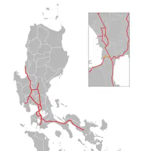 A map of expressways in Luzon, with the NAIA Expressway in orange | |
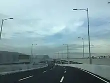
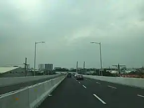 NAIA Expressway, looking south towards NAIA Road from Andrews Avenue in Pasay | |
| Route information | |
| Maintained by Vertex Tollways Development, Inc. | |
| Length | 11.6 km (7.2 mi) |
| Existed | 2016–present |
| Restrictions | Prohibited on expressway
|
| Major junctions | |
| West end | New Seaside Drive in Parañaque |
| East end | |
| Location | |
| Major cities | Parañaque, Pasay, Taguig |
| Highway system | |
| |
Route description
From the Sales Interchange (NAIA Exit) of Skyway, the expressway heads to the southwest and runs along Sales Road across Villamor Airbase and Newport City. It then curves to the northwest on Andrews Avenue towards the entrance to NAIA Terminal 3 and continues along the northern perimeter of the airport towards Electrical Road near NAIA Terminal 4. From here, it makes a turn to the south and runs along Parañaque River, parallel to Domestic Road on the east towards the NAIA Road junction. From this junction, the expressway branches into two, with one traversing eastwards to NAIA Terminals 1 and 2, while the other continues westwards to Entertainment City and the Manila–Cavite Expressway.
Unlike other limited-access highways in the Philippine expressway network, the maximum speed on the route is 60 kilometers per hour (37 mph).[3]
History
.jpg.webp)
Construction of the 1.6-kilometer (0.99 mi) NAIA Expressway Phase 1 (NAIA Terminal 3 Exit of Skyway) was completed in 2009[4] It provided an entry/exit ramp to the then newly-opened NAIA Terminal 3 and Resorts World Manila. On January 2, 2014, construction began on Phase 2 of the NAIA Expressway. It included a 7.15-kilometer (4.44 mi) extension of the expressway all the way to Macapagal Boulevard in Entertainment City, Parañaque via Andrews Avenue, Electrical Road (west of Domestic Road) and NAIA Road.[5][6]
On September 22, 2016 at exactly 12:01 AM (PST), the second phase of the airport expressway from Macapagal Boulevard to NAIA Terminals 1 and 2 was opened to all motorists and airport passengers rushing to their flights in order to avoid the traffic lights at every intersection along NAIA Road. The opening of the elevated airport expressway was led by Public Works and Highways Secretary Mark Villar. According to Transportation Secretary Arthur Tugade, the toll collection at the NAIAEx would begin on October 22, exactly one month after the opening of the airport tollway.[2]
On December 21, 2016 at exactly 6:00 AM (PST), the Entertainment City-NAIA Road-SLEX-Skyway segment (including the access ramp to Terminal 3) of the airport expressway was opened to all motorists for the Christmas rush.
On December 28, 2016, the access ramps to and from Manila-Cavite Expressway or CAVITEx were also opened to all motorists to provide easier access from the province of Cavite and Las Piñas to NAIA Terminals 1, 2 and 3 and vice versa.
On June 2, 2017, NAIAx was fully opened to all motorists.
Technical specifications
- Name: NAIA Expressway or NAIA Skyway
- Concession Holder: Vertex Tollways Development, Inc.[7]
- Operator: Skyway Operations and Maintenance Corp.[7]
- Concession starting date: November 2015[7]
- Concession ending date: November 2045[7]
- Length: 11.6 kilometers (7.2 mi)
- Highway exits: 8
- Exit ramps: 2 (Villamor, NAIA 3)
- Toll plazas: 1
- Height:
- Spurs: none
Tolls
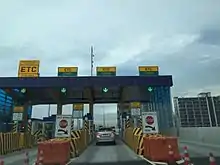
The expressway uses a barrier toll system, where toll collection is done at toll barriers on a fixed rate. The eastbound lanes of NAIAx employ toll collection at exit points and its main toll plaza in front of NAIA Terminal 3, while the westbound lanes employ toll collection on entry points, at its main toll plaza, and upon exit to Andrews Avenue. The expressway uses the Autosweep RFID electronic toll collection system, shared with Skyway, SLEX, and STAR Tollway.
Skyway system rates (September 22, 2016 – July 2017)
| Class | Toll |
|---|---|
| Class 1 (Cars, Motorcycles, SUVs, Jeepneys) |
₱20.00 |
| Class 2 (Buses, Light Trucks) |
₱40.00 |
Exits
The entire route is located in Metro Manila. Exits are numbered by kilometer posts at the center of the expressway, with Rizal Park in Manila designated as kilometer zero.
| City/Municipality | km | mi | Exit | Name | Destinations | Notes | ||
|---|---|---|---|---|---|---|---|---|
| Pasay – Taguig boundary | Sales Interchange; east end of expressway | |||||||
| Pasay | NAIAX toll plaza A (westbound and pass thru only) | |||||||
| 9.26 | 5.75 | NAIAX toll plaza B (eastbound and pass thru only) | ||||||
| 8.9 | 5.5 | Westbound exit and eastbound entrance; entrance ramp accessible via NAIA Terminal 3 | ||||||
| Eastbound exit and westbound entrance; access to | ||||||||
| NAIAX Main toll plaza A | ||||||||
| 7.7 | 4.8 | NAIAX Main toll plaza B | ||||||
| 7.2 | 4.5 | Southbound exit only | ||||||
| Pasay – Parañaque boundary | Directional T interchange; access to | |||||||
| Parañaque | 4.5 | 2.8 | Westbound exit and eastbound entrance | |||||
| 4.1– 3.8 | 2.5– 2.4 | Macapagal Boulevard | Westbound exit and eastbound entrance | |||||
| 4.1 | 2.5 | New Seaside Drive | Westbound exit and eastbound entrance; access to Okada Manila | |||||
1.000 mi = 1.609 km; 1.000 km = 0.621 mi
| ||||||||
References
- DPWH PPP Projects NAIA Archived November 22, 2014, at the Wayback Machine
- "NAIA Expressway finally opening on September 22". ABS-CBN News. ABS-CBN Corporation. Retrieved September 7, 2016.
- "Speed Limit". Toll Regulatory Board.
- "Arroyo inaugurates NAIA expressway before leaving for Korea". GMA News. May 30, 2009.
- NAIA Expressway Phase 2 Archived March 12, 2011, at the Wayback Machine
- "NAIA Expressway to be operational 2015". BusinessWorld. Retrieved August 11, 2014.
- "NAIAX". Toll Regulatory Board. Retrieved July 11, 2020.
| Existing |
| |||||||||||||
|---|---|---|---|---|---|---|---|---|---|---|---|---|---|---|
| Proposed |
| |||||||||||||
| Under construction | ||||||||||||||
See also: Philippine highway network | ||||||||||||||