Elpidio Quirino Avenue
Elpidio Quirino Avenue, also known simply as Quirino Avenue, is a major north-south collector road in Parañaque, southern Metro Manila, Philippines. It is a four-lane undivided arterial running parallel to Roxas Boulevard and its extension, the Manila–Cavite Expressway, to the west from Baclaran at Parañaque's border with Pasay in the north to San Dionisio right by the border with Las Piñas in the south. It is a continuation of Harrison Avenue from Pasay and was originally a segment of the coastal highway called Calle Real. The entire road is a component of Radial Road 2 (R-2) of Manila's arterial road network, while its segment south of NAIA Road is a component of National Route 62 (N62) of the Philippine highway network. It was previously designated as N1 on the old route numbering system. It was named after President Elpidio Quirino.
.svg.png.webp) R-2 | |
|---|---|
| Quirino Avenue | |
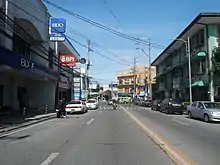 View northbound towards the Don Galo bridge in La Huerta | |
| Former name(s) | Calle Real / Camino Real |
| Part of | |
| Namesake | Elpidio Quirino |
| Maintained by | Department of Public Works and Highways - Metro Manila 2nd District Engineering Office[1] |
| Length | 5.6 km (3.5 mi) |
| Location | Parañaque |
| North end | Harrison Avenue, Taft Avenue Extension, and Redemptorist Road in Baclaran |
| Major junctions | Victor Medina Street |
| South end | |
Route description
The street starts at the intersection with F.B. Harrison Avenue, Redemptorist Road and Taft Avenue (Taft Avenue Extension) near Baclaran station, the current terminus of the elevated Manila LRT-1. It travels south across the crowded marketplace of Baclaran just behind the popular Baclaran Church and crosses Airport Road into barangay Tambo. The street then runs parallel to the Estero de Tripa de Gallina to the east which serves as Parañaque's border with Pasay and heads for the junction with NAIA Road and the elevated NAIA Expressway. A few hundred meters south, the road enters the barangay Don Galo and crosses the Parañaque River into the old center (poblacion) of Parañaque called La Huerta. It then curves slightly upon reaching the St. Andrew's Cathedral and straightens back as it heads south into barangay San Dionisio. The road intersects with Victor Medina Street near the Kabihasnan Entrance to the Manila-Cavite Expressway and ends just a few hundred meters south as it enters barangay Manuyo Uno in Las Piñas, where it continues as Diego Cera Avenue.
History

Elpidio Quirino Avenue marks the original shoreline of Manila Bay in Parañaque pueblo as it existed during the Spanish colonial period. It forms part of an old Spanish coastal highway that linked the Province of Manila to La Laguna and other southern provinces. It was called Calle Real or Camino Real (Spanish for "royal street") which spanned from Ermita to Muntinlupa, Rizal. It was the location of Camp Dewey, an early U.S. military installation during the Philippine–American War.[2] This "camp in Tambo" was converted into a Philippine Army camp in 1936.[3] However, by 2003, the military camp known as Camp Claudio has been transformed into a housing and urban development site.[4]
At present, only the Las Piñas and Muntinlupa section is called Calle Real or Real Street as an alternative name for the road. The Parañaque portion is renamed Elpidio Quirino Avenue while those of the City of Manila and Pasay have been renamed to M.H. Del Pilar Street and F.B. Harrison Avenue, respectively.
References
- "Road and Bridge Inventory". Department of Public Works and Highways. Retrieved August 30, 2020.
- Gentleman Soldier: John Clifford Brown and the Philippine-American War. Texas A&M University Press. 2004. ISBN 9781585442744. Retrieved April 4, 2015.
- "Proclamation No. 94, s. 1936". Official Gazette of the Republic of the Philippines. Retrieved April 4, 2015.
- "Proclamation No. 359, s. 2003". Official Gazette of the Republic of the Philippines. Retrieved April 4, 2015.